

Gäu Plateaus
Encyclopedia
Natural regions of Germany
This division of Germany into major natural regions takes account primarily of geomorphological, geological, hydrological and pedological criteria in order to divide the country into large, physical units with a common geographical basis...
in the German state of Baden-Württemberg
Baden-Württemberg
Baden-Württemberg is one of the 16 states of Germany. Baden-Württemberg is in the southwestern part of the country to the east of the Upper Rhine, and is the third largest in both area and population of Germany's sixteen states, with an area of and 10.7 million inhabitants...
. Not surprisingly, the individual geographical units of this large region show considerable variations in climate and soil types. A common feature of the region, however, is its landscape of flat-topped hills of Muschelkalk
Muschelkalk
The Muschelkalk is a sequence of sedimentary rock strata in the geology of central and western Europe. It has a Middle Triassic age and forms the middle part of the Germanic Trias, that further consists of the Buntsandstein and Keuper...
, gently rolling tracts of loess
Loess
Loess is an aeolian sediment formed by the accumulation of wind-blown silt, typically in the 20–50 micrometre size range, twenty percent or less clay and the balance equal parts sand and silt that are loosely cemented by calcium carbonate...
and plateau
Plateau
In geology and earth science, a plateau , also called a high plain or tableland, is an area of highland, usually consisting of relatively flat terrain. A highly eroded plateau is called a dissected plateau...
s in which the layers of Muschelkalk have been covered by sediment
Sediment
Sediment is naturally occurring material that is broken down by processes of weathering and erosion, and is subsequently transported by the action of fluids such as wind, water, or ice, and/or by the force of gravity acting on the particle itself....
s of Gipskeuper
Keuper
The Keuper is a lithostratigraphic unit in the subsurface of large parts of west and central Europe. The Keuper consists of dolostone, shales or claystones and evaporites that were deposited during the Middle and Late Triassic epochs...
and Lettenkeuper
Keuper
The Keuper is a lithostratigraphic unit in the subsurface of large parts of west and central Europe. The Keuper consists of dolostone, shales or claystones and evaporites that were deposited during the Middle and Late Triassic epochs...
.
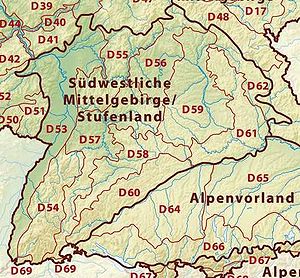
The Gäu Plateaus are the northwestern part of the Southern Scarplands.
Location and geology
The Gäu Plateaus extend from the Upper RhineUpper Rhine
The Upper Rhine is the section of the Rhine in the Upper Rhine Plain between Basel, Switzerland and Bingen, Germany. The river is marked by Rhine-kilometers 170 to 529 ....
to the Tauber valley
Tauber
For the singer, see Richard Tauber.For the mathematician, see Alfred Tauber.The Tauber is a river in Franconia, Germany. It is a left tributary of the Main and is 122 km in length...
. They are bordered to the west by the Black Forest
Black Forest
The Black Forest is a wooded mountain range in Baden-Württemberg, southwestern Germany. It is bordered by the Rhine valley to the west and south. The highest peak is the Feldberg with an elevation of 1,493 metres ....
and the Upper Rhine Plain
Upper Rhine Plain
The Upper Rhine Plain, Rhine Rift Valley or Upper Rhine Graben is a major rift, straddling the border between France and Germany. It forms part of the European Cenozoic Rift System, which extends across central Europe...
, to the north by the Odenwald
Odenwald
The Odenwald is a low mountain range in Hesse, Bavaria and Baden-Württemberg in Germany.- Location :The Odenwald lies between the Upper Rhine Rift Valley with the Bergstraße and the Hessisches Ried in the west, the Main and the Bauland in the east, the Hanau-Seligenstadt Basin – a subbasin of...
and the Mainfranken Plateaus, to the east by the Franconian and Swabian Keuper-Lias Lands and the Swabian Jura.
The underlying rock is made up of the layer of Muschelkalk
Muschelkalk
The Muschelkalk is a sequence of sedimentary rock strata in the geology of central and western Europe. It has a Middle Triassic age and forms the middle part of the Germanic Trias, that further consists of the Buntsandstein and Keuper...
, which is largely covered by Lettenkeuper
Keuper
The Keuper is a lithostratigraphic unit in the subsurface of large parts of west and central Europe. The Keuper consists of dolostone, shales or claystones and evaporites that were deposited during the Middle and Late Triassic epochs...
or loess
Loess
Loess is an aeolian sediment formed by the accumulation of wind-blown silt, typically in the 20–50 micrometre size range, twenty percent or less clay and the balance equal parts sand and silt that are loosely cemented by calcium carbonate...
. The soil
Soil
Soil is a natural body consisting of layers of mineral constituents of variable thicknesses, which differ from the parent materials in their morphological, physical, chemical, and mineralogical characteristics...
s in the region are mostly of very high quality.
Natural region subdivisions
In the Handbuch der naturräumlichen Gliederung Deutschlands ("Handbook of the natural regional divisions of Germany") which appeared from 1953 to 1962 the Neckar and Tauber Gäuplateaus are part of the German Central UplandsCentral Uplands
The Central Uplands is one of the three major natural regions of Germany and covers most of the land area of the country. To the north lies the North German Plain or Northern Lowland; to the south, the Alps and the Alpine Foreland.- Formation :...
and contain the following subdivisions (the handbook's regional numbers are shown in brackets):
- Alb-WutachWutachWutach can refer to*The Wutach, a river in Baden-Württemberg*The town of Wutach, one of the places the river flows through...
Region (120) - BaarBaar-Places:* Baar, Switzerland, a municipality in the Canton of Zug, Switzerland* Baar, Swabia, a town in western Bavaria, Germany* Baar, Rhineland-Palatinate, a municipality in Rhineland-Palatinate, Germany...
(121) - Upper Gäue (122)
- Neckar Basin (123)
- StrombergStromberg-People:*Lyndon Stromberg, American sculptor and designer*Karl Stromberg, the villain in the James Bond film The Spy Who Loved Me*Joseph R. Stromberg, historian with the Ludwig von Mises Institute*Glenn Strömberg, Swedish soccer player...
and Heuchelberg (124) - KraichgauKraichgauThe Kraichgau is a hilly region in Baden-Württemberg, southwestern Germany. It is bordered by the Odenwald and the Neckar to the North, the Black Forest to the South, and the Upper Rhine Plain to the West. To the east, its boundary is considered to be the Stromberg, the Hardt, and the...
(125) - KocherKocherThe Kocher is a 168 km long right tributary of the Neckar in the north-eastern part of Baden-Württemberg, Germany. The name "Kocher" originates from its Celtic name "cochan" and probably means winding, meandering river. The Kocher rises in the eastern foothills of the Swabian Alb from two karst...
-JagstJagstThe Jagst is a right tributary of the Neckar in northern Baden-Württemberg. It is 189 km long. Its source is in the hills east of Ellwangen, close to the Bavarian border. It winds through the towns Ellwangen, Crailsheim, Kirchberg an der Jagst, Langenburg, Krautheim, Möckmühl and Neudenau...
Plains (126) - Hohenloher Ebene and Haller EbeneHaller EbeneThe Haller Ebene is a plain in the German state of Baden-Württemberg which forms part of the Hohenloher Ebene and stretches from Bad Mergentheim via Rothenburg, Uffenheim, Crailsheim, Öhringen as far as Schwäbisch Hall. The Haller Ebene specifically refers to that region of the Hohenloher Ebene...
(127) - Bauland (128)
- Tauberland (129)
Natural regions of Germany according to the BfN
Based on the system of the Division of Germany into Major Natural Regional Units" (Gliederung Deutschlands in Naturräumliche Haupteinheiten) by the Federal Conservation Office (BfN) in 1994 the natural region is known as D57 Gäuplateaus, Neckar and Tauber Land (D57 Gäuplatten, Neckar- und Tauberland) but covers the same area.Name
The term Gau (in Alemannic GermanAlemannic German
Alemannic is a group of dialects of the Upper German branch of the Germanic language family. It is spoken by approximately ten million people in six countries: Switzerland, Germany, Austria, Liechtenstein, France and Italy...
: Gäu) was originally used to refer to open, treeless water meadows. Today the term Gäu landscapes (Gäulandschaften) is mainly used to refer to the open terraces of the Swabian-Franconian Scarplands and so includes the areas of open, fertile arable fields.
The name Neckar and Tauber Gäu Plateaus is to be seen as a collective reference for the Gäu landscapes located in the catchment area of the river Neckar
Neckar
The Neckar is a long river, mainly flowing through the southwestern state of Baden-Württemberg, but also a short section through Hesse, in Germany. The Neckar is a major right tributary of the River Rhine...
and its tributaries and which extend northeast to the catchment area of the Tauber
Tauber
For the singer, see Richard Tauber.For the mathematician, see Alfred Tauber.The Tauber is a river in Franconia, Germany. It is a left tributary of the Main and is 122 km in length...
.
Literature
- Kullen, Siegfried. Baden-Württemberg. 3., aktualisierte Auflage; Neubearbeitung. Klett, Stuttgart 1989 (Klett Länderprofile)
- Geyer, Otto F. & Gwinner, Manfred P. Geologie von Baden-Württemberg. E. Schweizerbart'sche Verlagsbuchhandlung, Stuttgart 1991.
- Borcherdt, Christoph. Bundesrepublik Deutschland. Wissenschaftliche Länderkunden Band 8. V. Baden-Württemberg. Darmstadt 1991.