

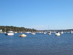
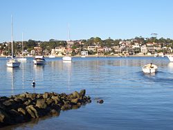
Gunnamatta Bay
Encyclopedia
Southern Sydney
This article refers to an area the same as a combination of St George and SutherlandSouthern Sydney is a general term which is used to describe the southern metropolitan area of Sydney, in the state of New South Wales, Australia....
Sydney
Sydney
Sydney is the most populous city in Australia and the state capital of New South Wales. Sydney is located on Australia's south-east coast of the Tasman Sea. As of June 2010, the greater metropolitan area had an approximate population of 4.6 million people...
, New South Wales
New South Wales
New South Wales is a state of :Australia, located in the east of the country. It is bordered by Queensland, Victoria and South Australia to the north, south and west respectively. To the east, the state is bordered by the Tasman Sea, which forms part of the Pacific Ocean. New South Wales...
, Australia
Australia
Australia , officially the Commonwealth of Australia, is a country in the Southern Hemisphere comprising the mainland of the Australian continent, the island of Tasmania, and numerous smaller islands in the Indian and Pacific Oceans. It is the world's sixth-largest country by total area...
.
Gunnamatta Bay is located off the Port Hacking
Port Hacking
Port Hacking is an Australian estuary, located in Southern Sydney, New South Wales and fed by the Hacking River and several smaller creeks, including Bundeena Creek and The Basin. It is a ria, a river basin which has become submerged by the sea...
estuary, in the Sutherland Shire
Sutherland Shire
The Sutherland Shire is a Local Government Area in the Southern Sydney region of Sydney, Australia. Geographically, it is the area to the south of Botany Bay and the Georges River...
. The foreshore is a natural boundary for the suburbs of Cronulla
Cronulla, New South Wales
Cronulla is a beachside suburb, in southern Sydney, in the state of New South Wales, Australia. Cronulla is located 26 kilometres south of the Sydney central business district, in the local government area of Sutherland Shire....
to the east, Woolooware
Woolooware, New South Wales
Woolooware is a suburb in southern Sydney, in the state of New South Wales, Australia. Woolooware is located south of the Sydney central business district in the Sutherland Shire. It shares the 2230 postcode with Cronulla....
to the north and Burraneer
Burraneer, New South Wales
Burraneer is a small suburb in southern Sydney, in the state of New South Wales, Australia. Burraneer is located 26 kilometres south of the Sydney central business district, in the local government area of the Sutherland Shire....
to the west.
Transport
Cronulla and National Park Ferry Cruises operate a ferry service from the wharf on Gunnamatta Bay, which provides a link between Cronulla and BundeenaBundeena, New South Wales
Bundeena is a village on the outskirts of southern Sydney, in the state of New South Wales, Australia. Bundeena is located 29km south of the Sydney central business district and is part of the local government area of the Sutherland Shire....
across Port Hacking, on the edge of the Royal National Park
Royal National Park
Royal National Park is a national park in New South Wales, Australia, 29 km south of Sydney CBD.Founded by Sir John Robertson, Acting Premier of New South Wales, and formally proclaimed on 26 April 1879, it is the world's second oldest purposed national park, the first usage of the term...
.
Parks
Gunnamatta Park and Darook Park are located on its eastern foreshore. Tonkin Oval on the northern foreshore features a large cricket oval and is also used for baseball. Cronulla Public School is located nearby.Gunnamatta park holds a valuable remnant of bushland canopy and a more limited but equally valuable understorey remnant. An unnusual but natural occurrence of Rough-Barked Apple-Gums (Angophora floribunda) grow in the park and are usually typical of the nearby Wianamatta Shale soil as opposed the Hawkesbury Sandstone on the site, this tree is virtually extinct in the Sutherland shire due to a complete lack of comprehensive reserves on shale soils, though this tree is still relativeley common on the Cumberland Plain in western Sydney and elsewhere in Australia.
History
Matthew FlindersMatthew Flinders
Captain Matthew Flinders RN was one of the most successful navigators and cartographers of his age. In a career that spanned just over twenty years, he sailed with Captain William Bligh, circumnavigated Australia and encouraged the use of that name for the continent, which had previously been...
and George Bass
George Bass
George Bass was a British naval surgeon and explorer of Australia.-Early years:He was born on 30 January 1771 at Aswarby, a hamlet near Sleaford, Lincolnshire, the son of a tenant farmer, George Bass, and a local beauty named Sarah Nee Newman. His father died in 1777 when Bass was 6...
explored and mapped the coastline and Port Hacking estuary in 1796 and the southernmost point of Cronulla is named Bass and Flinders Point, in their honour. Thomas Holt (1811–88) owned most of the land that stretched from Sutherland to Cronulla in the 1860s.
The area around the bay was subdivided in 1895 and land was offered for sale at 10 pounds per acre. In 1899, the government named the area Gunnamatta, which means sandy hills. On the 26th February 1908 it was officially changed to Cronulla and Gunnamatta was used for the name of the bay, on the western side.
Cronulla is derived from kurranulla, meaning ‘‘place of the pink seashells’’ in the dialect of the area's Aboriginal
Indigenous Australians
Indigenous Australians are the original inhabitants of the Australian continent and nearby islands. The Aboriginal Indigenous Australians migrated from the Indian continent around 75,000 to 100,000 years ago....
inhabitants, the Dharawal people. The beaches were named by Surveyor Robert Dixon
Robert Dixon (explorer)
Robert Dixon was an Australian surveyor and explorer, born in Darlington, England.-Arrival in Tasmania:Dixon arrived in Tasmania in May 1821 with his brother George...
who surveyed here in 1827-28 and by 1840, the main beach was still known as Karranulla.