

Guatiza
Encyclopedia
Teguise, Las Palmas
Teguise is a Canarian municipality and town in the north-central and the eastern portion of the island of Lanzarote in the Las Palmas province in the Canary Islands The population is 14,214 , its density is 53.84/km² and the area is 263.98 km². The town population is around 3,000...
in the northeastern portion of the island of Lanzarote
Lanzarote
Lanzarote , a Spanish island, is the easternmost of the autonomous Canary Islands, in the Atlantic Ocean, approximately 125 km off the coast of Africa and 1,000 km from the Iberian Peninsula. Covering 845.9 km2, it stands as the fourth largest of the islands...
in the Las Palmas
Las Palmas (province)
The Province of Las Palmas is a province of Spain, consisting of the eastern part of the autonomous community of the Canary Islands.-Composition:...
province in the Canary Islands
Canary Islands
The Canary Islands , also known as the Canaries , is a Spanish archipelago located just off the northwest coast of mainland Africa, 100 km west of the border between Morocco and the Western Sahara. The Canaries are a Spanish autonomous community and an outermost region of the European Union...
and is the northernmost in the Canary Islands as well as the easternmost. The population is 820 (ISTAC, 2003) which included 390 males and 430 females.
Information
Guatiza is located 8 km SE of downtown Teguise, 10 km north of Tahiche and 2 km north of Mala and ENE of Arrecife, south of HaríaHaría, Las Palmas
Haría is a municipality in the northern portion of the island of Lanzarote in the Las Palmas province of the Canary Islands and is the northernmost and easternmost Canarian municipality...
. The coastline is 2 km east, The main industry are agriculture and tourism. The Atlantic Ocean
Atlantic Ocean
The Atlantic Ocean is the second-largest of the world's oceanic divisions. With a total area of about , it covers approximately 20% of the Earth's surface and about 26% of its water surface area...
is to the east. The mountains are around Guatiza. Farmlands dominate the rest of the municipality including within Guatiza to the west and where Guatiza is situated. One of the hills are to the north and south. Guatiza is the famous town located near the grassy mountains and a small plain. The village has palm trees.
Guatiza was originally located on a slope of the mountain in which the cemetery stands today. In history, the Moors sacked Guatiza's homes several times in the past this was the reason that the homes are now located in a secure area from the pirates.
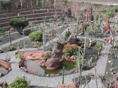
Guatiza is famous for its cactus garden hence the origin of the name Jardín de Cactus which covers 5,000 m² and has over 1,400 types of cactus and over 1,000 different species from America, Madagascar, the Canary Islands including local ones and local areas. The famous attraction was first created by César Manrique
César Manrique
César Manrique was an artist and an architect.-Biography:Manrique grew up in the area of San Ginés lagoon. At age 23, he participated in his first exhibition in Arrecife. He attended the University of La Laguna. In 1945, Manrique attended the art school San Fernando in Madrid for five years...
and is located on an old crater which is extracted from the volcanic soil. The population of Guatiza has about 820 persons. The volcanoes in the area are Guenia, Tinamala, La Caldera and Las Calderetas.
Geography
- Location:
- Latitude: 29.0667 (29°4') N
- Longitude: 13.4667 (13°28') W
- Altitude:
- Lowest: about 10 to 20 m
- Postal code: 35520
Climate
The precipitation is mainly dry with little rains. Humidity is constant. The temperatures ranges from 18º in January and 25º in August. The nighttime or low temperatures are between 15º and 23°.External links
- http://www.guatiza.com (in Spanish)
- Interacitve Panorama: Cactus Garden