

Haría, Las Palmas
Encyclopedia
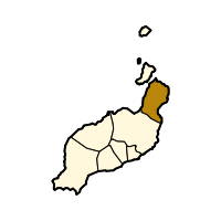
Lanzarote
Lanzarote , a Spanish island, is the easternmost of the autonomous Canary Islands, in the Atlantic Ocean, approximately 125 km off the coast of Africa and 1,000 km from the Iberian Peninsula. Covering 845.9 km2, it stands as the fourth largest of the islands...
in the Las Palmas
Las Palmas (province)
The Province of Las Palmas is a province of Spain, consisting of the eastern part of the autonomous community of the Canary Islands.-Composition:...
province of the Canary Islands
Canary Islands
The Canary Islands , also known as the Canaries , is a Spanish archipelago located just off the northwest coast of mainland Africa, 100 km west of the border between Morocco and the Western Sahara. The Canaries are a Spanish autonomous community and an outermost region of the European Union...
and is the northernmost and easternmost Canarian municipality. Surrounded on three sides by the Atlantic Ocean
Atlantic Ocean
The Atlantic Ocean is the second-largest of the world's oceanic divisions. With a total area of about , it covers approximately 20% of the Earth's surface and about 26% of its water surface area...
, the municipality is bordered to the south by the municipality of Teguise
Teguise, Las Palmas
Teguise is a Canarian municipality and town in the north-central and the eastern portion of the island of Lanzarote in the Las Palmas province in the Canary Islands The population is 14,214 , its density is 53.84/km² and the area is 263.98 km². The town population is around 3,000...
.
Demographics
The population is 4,741 (http://www.gobiernodecanarias.org/istac/ISTAC, 2003), some of whom live on the island of GraciosaGraciosa, Canary Islands
There is also a Graciosa in the Azores, see GraciosaGraciosa Island or commonly La Graciosa is a volcanic island in the Canary Islands of Spain, located 2 km north of the island of Lanzarote with the strait named Río. It was formed by the Canary hotspot...
. The total land area of the municipality is 106.58 km², giving a population density of 44.48/km²; population growth from 2001 to 2003 stood at 9.62%.
Geography
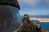
The west of the municipality is largely mountainous, with much of the western coastline rising steeply a little way inland. Numerous miradors (viewpoints) on this high ground offer some of the island's most spectacular views, the most well known being the Mirador del RioMirador del Río
Mirador del Río is a viewpoint situated on an approximately 475 meters high escarpment called Batería del Río in the very north of the Canarian island of Lanzarote....
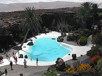
which is a popular tourist attraction. To the southeast the land is low-lying and largely used for agriculture, with many small beach resorts along the coast. The northeast of the municipality is largely uninhabited, having been buried approximately 3000 years ago by the eruption of the Montaña Corona which formed the inhospitable Malpais de la Corona. This eruption also produced extensive hollow lava tunnels called jameos, some of which have been developed into two of the island's most-visited geological attractions: the Cueva de los Verdes
Cueva de los Verdes
Cueva de los Verdes is a lava tube located in the island of Lanzarote in the Canary Islands ....
and the Jameos del Agua.
- Location:
- Latitude: 29.133 (29°8') N
- Longitude: 13.433 (13°26') W
- Altitude:
- Lowest: Atlantic Ocean
- Centre: 270 m
- Postal code: 35520
Communities
- ArrietaArrieta, LanzaroteArrieta is a village in the municipality of Haría in the Las Palmas province of northern Lanzarote in the Canary Islands....
- Casa La BreñaCasa La BreñaCasa La Breña is a village in the municipality of Haría in the Las Palmas province of northern Lanzarote in the Canary Islands....
- Casas Las EscarnasCasas Las EscarnasCasas Las Escarnas is a village in the municipality of Haría in the Las Palmas province of northern Lanzarote in the Canary Islands....
- Charco del PaloCharco del PaloCharco del Palo is a small village on the Eastern coast of Lanzarote, in the Canary Islands. It is located in the municipality of Haría, near the villages of Mala and Guatiza. The village was established around 1970 by the German entrepreneur Gregor Kaiser. In due course, it has developed into a...
- GuinateGuinateGuinate is a village in the municipality of Haría in northern Lanzarote in the Las Palmas province of Spain .The village has a large tropical park which has numerous bird species, including penguins, and many plants and animals. On the cost there is El Mirador de Guinate which has fine views of...
- Los MolinosLos Molinos, LanzaroteLos Molinos is a village in the municipality of Haría in the Las Palmas province of northern Lanzarote in the Canary Islands....
- MáguesMáguesMágues is a village in the municipality of Haría in the Las Palmas province of northern Lanzarote in the Canary Islands....
- ÓrzolaÓrzolaÓrzola is a village in the municipality of Haría in the Las Palmas province of northern Lanzarote in the Canary Islands. It is the departure point for the ferry to La Graciosa....
- Punta MujeresPunta MujeresPunta Mujeres is a village in the municipality of Haría in the Las Palmas province of northern Lanzarote in the Canary Islands....
- TabayescoTabayescoTabayesco is a village in the municipality of Haría in the Las Palmas province of northern Lanzarote in the Canary Islands....
- YeYe, LanzaroteYé is a village in the municipality of Haría in the Las Palmas province of northern Lanzarote in the Canary Islands....
Sites of interest
- Mirador del RioMirador del RíoMirador del Río is a viewpoint situated on an approximately 475 meters high escarpment called Batería del Río in the very north of the Canarian island of Lanzarote....
- Jameos del Agua
- Cave of los VerdesCueva de los VerdesCueva de los Verdes is a lava tube located in the island of Lanzarote in the Canary Islands ....
- Montaña Corona
See also
| North: Atlantic Ocean | ||
| West: Atlantic Ocean |
Haría | East: Atlantic Ocean |
| South: Teguise Teguise, Las Palmas Teguise is a Canarian municipality and town in the north-central and the eastern portion of the island of Lanzarote in the Las Palmas province in the Canary Islands The population is 14,214 , its density is 53.84/km² and the area is 263.98 km². The town population is around 3,000... |