
Greenwood County, Kansas
Encyclopedia
Greenwood County is a county located in Southeast
Kansas
, in the Central
United States
. As of the 2010 census, the county population was 6,689. Its county seat
and most populous city is Eureka
.
, county until the Kansas Constitution was amended in 1986 and voters approved the sale of alcoholic liquor by the individual drink with a 30% food sales requirement.
 As of the U.S. Census in 2000
, there were 7,673 people, 3,234 households, and 2,153 families residing in the county. The population density
was 7 people per square mile (3/km²). There were 4,273 housing units at an average density of 4 per square mile (1/km²). The racial makeup
of the county was 96.53% White
, 0.83% Native American
, 0.14% Black or African American
, 0.10% Asian
, 0.81% from other races, and 1.58% from two or more races
. Hispanic
or Latino
of any race were 1.72% of the population.
There were 3,234 household
s out of which 27.10% had children under the age of 18 living with them, 56.50% were married couples
living together, 6.60% had a female householder with no husband present, and 33.40% were non-families. 30.30% of all households were made up of individuals and 16.80% had someone living alone who was 65 years of age or older. The average household size was 2.31 and the average family size was 2.86.
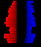
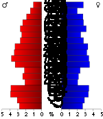
In the county the population was spread out with 23.70% under the age of 18, 6.50% from 18 to 24, 23.20% from 25 to 44, 23.70% from 45 to 64, and 22.80% who were 65 years of age or older. The median age was 43 years. For every 100 females there were 95.50 males. For every 100 females age 18 and over, there were 91.50 males.
The median income for a household
in the county was $30,169, and the median income for a family was $38,140. Males had a median income of $27,021 versus $19,356 for females. The per capita income
for the county was $15,976. About 8.20% of families and 12.50% of the population were below the poverty line, including 16.20% of those under age 18 and 10.10% of those age 65 or over.
. The city of Eureka
is considered governmentally independent and is excluded from the census figures for the townships. In the following table, the population center is the largest city (or cities) included in that township's population total, if it is of a significant size.
Additional information
Maps
Southeast Kansas
Southeast Kansas is a region of the U.S. state of Kansas. It can be roughly defined by Woodson County in the northwest, Bourbon County in the northeast, Cherokee County in the southeast, and Montgomery County in the southwest. Geographically it is dominated by a broad rolling landscape located...
Kansas
Kansas
Kansas is a US state located in the Midwestern United States. It is named after the Kansas River which flows through it, which in turn was named after the Kansa Native American tribe, which inhabited the area. The tribe's name is often said to mean "people of the wind" or "people of the south...
, in the Central
Central United States
The Central United States is sometimes conceived as between the Eastern United States and Western United States as part of a three-region model, roughly coincident with the Midwestern United States plus the western and central portions of the Southern United States; the term is also sometimes used...
United States
United States
The United States of America is a federal constitutional republic comprising fifty states and a federal district...
. As of the 2010 census, the county population was 6,689. Its county seat
County seat
A county seat is an administrative center, or seat of government, for a county or civil parish. The term is primarily used in the United States....
and most populous city is Eureka
Eureka, Kansas
Eureka is a city in and the county seat of Greenwood County, Kansas, United States. As of the 2010 census, the city population was 2,633.-History:...
.
Law and government
Greenwood County was a prohibition, or "dry"Dry county
A dry county is a county in the United States whose government forbids the sale of alcoholic beverages. Some prohibit off-premises sale, some prohibit on-premises sale, and some prohibit both. Hundreds of dry counties exist across the United States, almost all of them in the South...
, county until the Kansas Constitution was amended in 1986 and voters approved the sale of alcoholic liquor by the individual drink with a 30% food sales requirement.
Geography
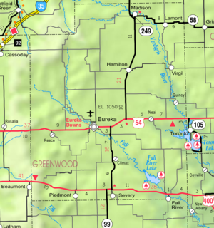
According to the 2000 census, the county has a total area of 1152.59 square miles (2,985.2 km²), of which 1139.67 square miles (2,951.7 km²) (or 98.88%) is land and 12.92 square miles (33.5 km²) (or 1.12%) is water.Adjacent counties
- Lyon CountyLyon County, KansasLyon County is a county located in the U.S. state of Kansas. The county was named for General Nathaniel Lyon, who was killed at the Battle of Wilson's Creek in the Civil War. As of the 2010 census, the county population was 33,690. Emporia is the largest city and county seat...
(north) - Coffey CountyCoffey County, KansasCoffey County is a county located in East Central Kansas, in the Central United States. As of the 2010 census, the county population was 8,601...
(northeast) - Woodson CountyWoodson County, KansasWoodson County is a county located in the U.S. state of Kansas. As of the 2010 census, the county population was 3,309...
(east) - Wilson CountyWilson County, KansasWilson County is a county located in the U.S. state of Kansas. As of the 2010 census, the county population was 9,409...
(southeast) - Elk CountyElk County, KansasElk County is a county located in Southeast Kansas, in the Central United States. As of the 2010 census, the county population was 2,882...
(south) - Butler CountyButler County, KansasButler County is a county located in South Central Kansas, in the Central United States. As of the 2010 census, the county population was 65,880. Its county seat and most populous city is El Dorado. The county is a part of the Wichita Metropolitan Statistical Area.-19th century:It was named in...
(west) - Chase CountyChase County, KansasChase County is a county located in Central Kansas, in the Central United States. As of the 2010 census, the county population was 2,790. Its county seat and most populous city is Cottonwood Falls. Chase County is part of the Emporia Micropolitan Statistical Area.The county has been the subject...
(northwest)
Demographics
United States Census, 2000
The Twenty-second United States Census, known as Census 2000 and conducted by the Census Bureau, determined the resident population of the United States on April 1, 2000, to be 281,421,906, an increase of 13.2% over the 248,709,873 persons enumerated during the 1990 Census...
, there were 7,673 people, 3,234 households, and 2,153 families residing in the county. The population density
Population density
Population density is a measurement of population per unit area or unit volume. It is frequently applied to living organisms, and particularly to humans...
was 7 people per square mile (3/km²). There were 4,273 housing units at an average density of 4 per square mile (1/km²). The racial makeup
Race (United States Census)
Race and ethnicity in the United States Census, as defined by the Federal Office of Management and Budget and the United States Census Bureau, are self-identification data items in which residents choose the race or races with which they most closely identify, and indicate whether or not they are...
of the county was 96.53% White
White American
White Americans are people of the United States who are considered or consider themselves White. The United States Census Bureau defines White people as those "having origins in any of the original peoples of Europe, the Middle East, or North Africa...
, 0.83% Native American
Native Americans in the United States
Native Americans in the United States are the indigenous peoples in North America within the boundaries of the present-day continental United States, parts of Alaska, and the island state of Hawaii. They are composed of numerous, distinct tribes, states, and ethnic groups, many of which survive as...
, 0.14% Black or African American
African American
African Americans are citizens or residents of the United States who have at least partial ancestry from any of the native populations of Sub-Saharan Africa and are the direct descendants of enslaved Africans within the boundaries of the present United States...
, 0.10% Asian
Asian American
Asian Americans are Americans of Asian descent. The U.S. Census Bureau definition of Asians as "Asian” refers to a person having origins in any of the original peoples of the Far East, Southeast Asia, or the Indian subcontinent, including, for example, Cambodia, China, India, Indonesia, Japan,...
, 0.81% from other races, and 1.58% from two or more races
Multiracial
The terms multiracial and mixed-race describe people whose ancestries come from multiple races. Unlike the term biracial, which often is only used to refer to having parents or grandparents of two different races, the term multiracial may encompass biracial people but can also include people with...
. Hispanic
Hispanic
Hispanic is a term that originally denoted a relationship to Hispania, which is to say the Iberian Peninsula: Andorra, Gibraltar, Portugal and Spain. During the Modern Era, Hispanic sometimes takes on a more limited meaning, particularly in the United States, where the term means a person of ...
or Latino
Latino
The demonyms Latino and Latina , are defined in English language dictionaries as:* "a person of Latin-American descent."* "A Latin American."* "A person of Hispanic, especially Latin-American, descent, often one living in the United States."...
of any race were 1.72% of the population.
There were 3,234 household
Household
The household is "the basic residential unit in which economic production, consumption, inheritance, child rearing, and shelter are organized and carried out"; [the household] "may or may not be synonymous with family"....
s out of which 27.10% had children under the age of 18 living with them, 56.50% were married couples
Marriage
Marriage is a social union or legal contract between people that creates kinship. It is an institution in which interpersonal relationships, usually intimate and sexual, are acknowledged in a variety of ways, depending on the culture or subculture in which it is found...
living together, 6.60% had a female householder with no husband present, and 33.40% were non-families. 30.30% of all households were made up of individuals and 16.80% had someone living alone who was 65 years of age or older. The average household size was 2.31 and the average family size was 2.86.
In the county the population was spread out with 23.70% under the age of 18, 6.50% from 18 to 24, 23.20% from 25 to 44, 23.70% from 45 to 64, and 22.80% who were 65 years of age or older. The median age was 43 years. For every 100 females there were 95.50 males. For every 100 females age 18 and over, there were 91.50 males.
The median income for a household
Median household income
The median household income is commonly used to generate data about geographic areas and divides households into two equal segments with the first half of households earning less than the median household income and the other half earning more...
in the county was $30,169, and the median income for a family was $38,140. Males had a median income of $27,021 versus $19,356 for females. The per capita income
Per capita income
Per capita income or income per person is a measure of mean income within an economic aggregate, such as a country or city. It is calculated by taking a measure of all sources of income in the aggregate and dividing it by the total population...
for the county was $15,976. About 8.20% of families and 12.50% of the population were below the poverty line, including 16.20% of those under age 18 and 10.10% of those age 65 or over.
Incorporated cities
Name and population (2004 estimate):- EurekaEureka, KansasEureka is a city in and the county seat of Greenwood County, Kansas, United States. As of the 2010 census, the city population was 2,633.-History:...
, 2,821 (county seat) - MadisonMadison, KansasMadison is a city in Greenwood County, Kansas, United States, along the Verdigris River. As of the 2010 census, the city population was 701.-Geography:Madison is located at...
, 823 - SeverySevery, KansasSevery is a city in Greenwood County, Kansas, United States. As of the 2010 census, the city population was 259.-Geography:Severy is located at , along K-99 south of its intersection with U.S. Route 400...
, 359 - HamiltonHamilton, KansasHamilton is a city in Greenwood County, Kansas, United States. As of the 2010 census, the city population was 268. The city was named in honor of Alexander Hamilton, first Secretary of the Treasury.The city should not be confused with Hamilton County....
, 333 - Fall RiverFall River, KansasFall River is a city in Greenwood County, Kansas, United States. As of the 2010 census, the city population was 162.-Geography:Fall River is located at...
, 156 - VirgilVirgil, KansasVirgil is a city in Greenwood County, Kansas, United States. As of the 2010 census, the city population was 71.-Geography:Virgil is located at . According to the United States Census Bureau, the city has a total area of , all of it land.-Demographics:As of the census of 2000, there were 113...
, 112 - ClimaxClimax, KansasClimax is a city in Greenwood County, Kansas, United States. As of the 2010 census, the city population was 72.-History:Climax began to grow around a school founded at the site of the present town in 1873...
, 64
Townships
Greenwood County is divided into fifteen townshipsCivil township
A civil township is a widely used unit of local government in the United States, subordinate to, and geographic divisions of, a county. Specific responsibilities and the degree of autonomy vary based on each state. Civil townships are distinct from survey townships, but in states that have both,...
. The city of Eureka
Eureka, Kansas
Eureka is a city in and the county seat of Greenwood County, Kansas, United States. As of the 2010 census, the city population was 2,633.-History:...
is considered governmentally independent and is excluded from the census figures for the townships. In the following table, the population center is the largest city (or cities) included in that township's population total, if it is of a significant size.
| Township | FIPS | Population center |
Population | Population density /km² (/sq mi) |
Land area km² (sq mi) | Water area km² (sq mi) | Water % | Geographic coordinates |
|---|---|---|---|---|---|---|---|---|
| Bachelor | 03625 | 230 | 1 (4) | 155 (60) | 1 (0) | 0.70% | 37°49′57"N 96°12′21"W | |
| Eureka | 21825 | 451 | 3 (8) | 149 (58) | 2 (1) | 1.50% | 37°50′41"N 96°17′49"W | |
| Fall River | 22800 | 229 | 1 (4) | 154 (60) | 2 (1) | 1.13% | 37°42′36"N 96°12′4"W | |
| Janesville | 35000 | 548 | 1 (4) | 371 (143) | 2 (1) | 0.62% | 37°59′4"N 96°11′29"W | |
| Lane | 38425 | 167 | 1 (3) | 138 (53) | 1 (0) | 0.52% | 37°58′36"N 96°0′59"W | |
| Madison | 44075 | 1,155 | 4 (9) | 320 (124) | 3 (1) | 0.85% | 38°7′32"N 96°12′11"W | |
| Otter Creek | 53650 | 211 | 1 (2) | 290 (112) | 2 (1) | 0.55% | 37°40′20"N 96°24′0"W | |
| Pleasant Grove | 56375 | 52 | 0 (1) | 150 (58) | 2 (1) | 1.57% | 37°47′21"N 96°1′41"W | |
| Quincy | 58175 | 163 | 1 (3) | 155 (60) | 1 (0) | 0.38% | 37°51′8"N 96°2′59"W | |
| Salem | 62650 | 35 | 0 (0) | 233 (90) | 2 (1) | 0.89% | 38°1′45"N 96°24′29"W | |
| Salt Springs | 62875 | 463 | 3 (7) | 182 (70) | 10 (4) | 5.16% | 37°38′55"N 96°3′59"W | |
| Shell Rock | 64600 | 173 | 1 (3) | 136 (53) | 1 (0) | 0.87% | 38°5′53"N 96°1′18"W | |
| South Salem | 66925 | 127 | 1 (1) | 224 (87) | 3 (1) | 1.13% | 37°52′42"N 96°27′4"W | |
| Spring Creek | 67425 | 154 | 1 (3) | 139 (54) | 1 (1) | 0.93% | 37°47′49"N 96°26′50"W | |
| Twin Grove | 71825 | 601 | 4 (11) | 148 (57) | 1 (0) | 0.57% | 37°38′7"N 96°14′3"W | |
| Sources: | ||||||||
Education
Unified school districts
See also
- National Register of Historic Places listings in Greenwood County, KansasNational Register of Historic Places listings in Greenwood County, KansasThis is a list of the National Register of Historic Places listings in Greenwood County, Kansas.This is intended to be a complete list of the properties on the National Register of Historic Places in Greenwood County, Kansas, United States...
Further reading
- History of the State of Kansas; William G. Cutler; A.T. Andreas Publisher; 1883. (Online HTML eBook)
- Kansas : A Cyclopedia of State History, Embracing Events, Institutions, Industries, Counties, Cities, Towns, Prominent Persons, Etc; 3 Volumes; Frank W. Blackmar; Standard Publishing Co; 944 / 955 / 824 pages; 1912. (Volume1 - Download 54MB PDF eBook),(Volume2 - Download 53MB PDF eBook), (Volume3 - Download 33MB PDF eBook)
External links
Official sitesAdditional information
Maps
- Greenwood County Map, KDOT
- Kansas Highway Map, KDOT
- Kansas Railroad Map, KDOT
- Kansas School District Boundary Map, KSDE