
Great Smoky Mountains Expressway
Encyclopedia
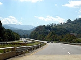
The Great Smoky Mountains Expressway is a four-lane divided highway
in southwestern North Carolina
, which runs between Interstate 40
(exit 27) near Canton
in the east to the Nantahala National Forest
near Needmore in the west. It traverses western Haywood
, northern Jackson
, and eastern Swain
counties, respectively.
follows the expressway for its entire length, with U.S. routes 19
, 23 and 441
also following the route
at various times. Prior to the 1980s, most of the road (parts of which were later relocated) was called U.S. 19 Alternate. The state considered calling the highway U.S. 19 and making the highway through Maggie Valley
U.S. 19-A, but business owners in Maggie Valley opposed this. In January 1983, the state also considered calling the highway U.S. 19 Bypass, but made the expressway designation instead a year later.
 The expressway
is limited-access much like an Interstate highway at various points along its route, including stretches between Interstate 40 and the west side of Waynesville
, through Sylva
and near Cherokee
. While the route does include some at-grade intersection
s, there are currently no traffic signals along the route to impede traffic.
The Great Smoky Mountains Expressway roughly follows the route of the historic Murphy Branch
of the Western North Carolina Railroad
, now owned by the Norfolk Southern Railway
and the Great Smoky Mountains Railroad
. Much like the railroad was before it, the Great Smoky Mountains Expressway was and still is important in connecting the mostly rural
areas in the southwest to the rest of the state. However, there is very little traffic compared to typical expressways, as there is no other major route or population center for it to connect to in the southwest.
Divided Highway
Divided Highway is a compilation album by American rock band The Doobie Brothers, released in 2003. . All tracks are taken from the albums Cycles and Brotherhood .-Track listing:...
in southwestern North Carolina
Western North Carolina
Western North Carolina is the region of North Carolina which includes the Appalachian Mountains, thus it is often known geographically as the state's Mountain Region. It is sometimes included with upstate South Carolina as the "Western Carolinas", which is also counted as a single media market...
, which runs between Interstate 40
Interstate 40 in North Carolina
Interstate 40 runs through the state of North Carolina from the Tennessee state line in the west to its eastern terminus in Wilmington.-Pigeon River Gorge:...
(exit 27) near Canton
Canton, North Carolina
Canton is the second largest town in Haywood County, North Carolina, United States. It is located about west of Asheville, North Carolina and is part of the Asheville Metropolitan Statistical Area. The town is named after the city of Canton, Ohio.- History :...
in the east to the Nantahala National Forest
Nantahala National Forest
The Nantahala National Forest, established in 1920, is a national forest located in the American state of North Carolina. The word "Nantahala" is a Cherokee word meaning "Land of the Noonday Sun." The name is appropriate as, in some spots, the sun only reaches the floors of the deep gorges of the...
near Needmore in the west. It traverses western Haywood
Haywood County, North Carolina
-National protected areas:* Blue Ridge Parkway * Great Smoky Mountains National Park * Pisgah National Forest -Major Highways & Roads:* Interstate 40* U.S. Highway 19* U.S. Highway 23* U.S. Highway 74* U.S...
, northern Jackson
Jackson County, North Carolina
Jackson County is a county located in the southwest of the U.S. state of North Carolina. As of 2010, the population was 40,271. Since 1913 its county seat has been Sylva, replacing Webster.-History:...
, and eastern Swain
Swain County, North Carolina
Swain County is a county located in the U.S. state of North Carolina. As of 2000, the population was 12,968. Its county seat is Bryson City.Swain County is home of the Nantahala River . The Nantahala is one of the most popular whitewater rafting rivers in the nation...
counties, respectively.
Route description
U.S. 74U.S. Route 74
U.S. Route 74 is an east–west United States highway that runs for from Cleveland, Tennessee to Wrightsville Beach, North Carolina.-Tennessee:Established in 1987, US-74 western terminus is exit 20 on I-75 in Cleveland...
follows the expressway for its entire length, with U.S. routes 19
U.S. Route 19
U.S. Route 19 is a north–south U.S. Highway. Despite encroaching Interstate Highways, the route has remained a long-haul route, connecting the Gulf of Mexico with Lake Erie....
, 23 and 441
U.S. Route 441
U.S. Route 441 is a spur route of U.S. Route 41. It currently runs for 939 miles from U.S. Route 41 in Miami, Florida to U.S. Route 25W in Lake City, Tennessee. Between its termini, US 441 passes through the states of Florida, Georgia, North Carolina, and Tennessee...
also following the route
Concurrency (road)
A concurrency, overlap, or coincidence in a road network is an instance of one physical road bearing two or more different highway, motorway, or other route numbers...
at various times. Prior to the 1980s, most of the road (parts of which were later relocated) was called U.S. 19 Alternate. The state considered calling the highway U.S. 19 and making the highway through Maggie Valley
Maggie Valley, North Carolina
Maggie Valley is a town in Haywood County, North Carolina, USA. The population was 607 at the 2000 census. It is home to the Ghost Town in the Sky amusement park.Maggie Valley is part of the Asheville Metropolitan Statistical Area....
U.S. 19-A, but business owners in Maggie Valley opposed this. In January 1983, the state also considered calling the highway U.S. 19 Bypass, but made the expressway designation instead a year later.
History
Limited-access road
A limited-access road known by various terms worldwide, including limited-access highway, dual-carriageway and expressway, is a highway or arterial road for high-speed traffic which has many or most characteristics of a controlled-access highway , including limited or no access to adjacent...
is limited-access much like an Interstate highway at various points along its route, including stretches between Interstate 40 and the west side of Waynesville
Waynesville, North Carolina
Waynesville is a town in and the county seat of Haywood County, North Carolina, United States. It is the largest town in Haywood County and the largest in Western North Carolina west of Asheville. Waynesville is located about or 50 km southwest of Asheville between the Great Smoky and Blue...
, through Sylva
Sylva, North Carolina
Sylva is an incorporated town located in central Jackson County, in the Great Smoky Mountains of Western North Carolina, United States of America. As of the 2010 census, the town had a total population of 2,588. It is the county seat, having taken over from nearby Webster in 1913.-Geography:Sylva...
and near Cherokee
Cherokee, North Carolina
Cherokee is a town in Swain County, North Carolina, USA, within the Qualla Boundary land trust. It is located in the Oconaluftee River Valley, near the intersection of U.S. Route 19 and U.S...
. While the route does include some at-grade intersection
At-grade intersection
An at-grade intersection is a junction at which two or more transport axes cross at the same level .-Traffic management:With areas of high or fast traffic, an at-grade intersection normally requires a traffic control device such as a stop sign, traffic light or railway signal to manage conflicting...
s, there are currently no traffic signals along the route to impede traffic.
The Great Smoky Mountains Expressway roughly follows the route of the historic Murphy Branch
Murphy Branch
The historically important Murphy Branch is the western most part of what was the Western North Carolina Railroad, later the Richmond and Danville, Southern Railway and today the Norfolk Southern Railway. The branch runs between Asheville, North Carolina in the east and Andrews in the west. It...
of the Western North Carolina Railroad
Western North Carolina Railroad
The Western North Carolina Railroad was a 19th century railroad that ran from Salisbury to Murphy, North Carolina.Future American Civil War officer Samuel McDowell Tate was instrumental in planning and sponsoring the construction of the first leg of the railroad in 1855, then in managing it in the...
, now owned by the Norfolk Southern Railway
Norfolk Southern Railway
The Norfolk Southern Railway is a Class I railroad in the United States, owned by the Norfolk Southern Corporation. With headquarters in Norfolk, Virginia, the company operates 21,500 route miles in 22 eastern states, the District of Columbia and the province of Ontario, Canada...
and the Great Smoky Mountains Railroad
Great Smoky Mountains Railroad
The Great Smoky Mountains Railroad is a freight and heritage railroad in North Carolina with a depot in Bryson City. The railroad operates over the western leg of the "Murphy Branch", a former branch line of the Southern Railway....
. Much like the railroad was before it, the Great Smoky Mountains Expressway was and still is important in connecting the mostly rural
Rural
Rural areas or the country or countryside are areas that are not urbanized, though when large areas are described, country towns and smaller cities will be included. They have a low population density, and typically much of the land is devoted to agriculture...
areas in the southwest to the rest of the state. However, there is very little traffic compared to typical expressways, as there is no other major route or population center for it to connect to in the southwest.