

Great County Adit
Encyclopedia
The Great County Adit, sometimes called the County Adit, or the Great Adit was a system of interconnected adit
s that helped drain water from the tin and copper mines in the Gwennap
area of Cornwall
, in the United Kingdom
. Construction started in 1748 and it eventually consisted of nearly 40 miles of underground tunnels, providing drainage to over 60 mines.
The adit was the brainchild of John Williams
(born 1714) of Scorrier
who was the manager of Poldice mine. Although work was started in 1748, it did not reach Poldice mine until the late 1760s. By 1778 the adit had been extended past Wheal Busy
to Wheal Peevor
, and another branch, known as the Consols Adit was driven west in the 1770s and 80s to drain the Consolidated Mines
and United Mines. By 1792 a branch from Poldice extended to Wheal Unity.
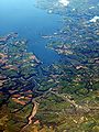 The portal of the adit is in the Carnon Valley below the hamlet of Twelveheads
. In 1839, probably at its peak, it discharged over 14.5 million gallons per day into the Carnon River, which empties into Restronguet Creek
(a tidal arm of the Carrick Roads
upstream from Falmouth
). Major floods in the winter of 1876 caused large quantities of gangue
and silt to be washed into the higher part of Restronguet Creek, permanently damaging the navigation to the upper quays at Devoran
.
Although all the mines served by the Great County Adit have closed and it is unmaintained, it still drains many of their underground workings today; in the summer of 1980 the flow was 500,000 gallons per day.
Adit
An adit is an entrance to an underground mine which is horizontal or nearly horizontal, by which the mine can be entered, drained of water, and ventilated.-Construction:...
s that helped drain water from the tin and copper mines in the Gwennap
Gwennap
Gwennap is a village and civil parish in Cornwall, United Kingdom. It is situated approximately five miles southeast of Redruth....
area of Cornwall
Cornwall
Cornwall is a unitary authority and ceremonial county of England, within the United Kingdom. It is bordered to the north and west by the Celtic Sea, to the south by the English Channel, and to the east by the county of Devon, over the River Tamar. Cornwall has a population of , and covers an area of...
, in the United Kingdom
United Kingdom
The United Kingdom of Great Britain and Northern IrelandIn the United Kingdom and Dependencies, other languages have been officially recognised as legitimate autochthonous languages under the European Charter for Regional or Minority Languages...
. Construction started in 1748 and it eventually consisted of nearly 40 miles of underground tunnels, providing drainage to over 60 mines.
The adit was the brainchild of John Williams
Williams family of Caerhays and Burncoose
The Williams family of Caerhays and Burncoose, were, for several generations, dominant in the Cornish Industrial Revolution as owners of mines and smelting works...
(born 1714) of Scorrier
Scorrier
Scorrier is a village in Cornwall, in the United Kingdom. It is about 2 miles northeast of the centre of Redruth and 3 miles south-east of the coast at Porthtowan, on the A30 road at the junction of the A3047 road that leads west to Camborne and the B3298 road south to Carharrack...
who was the manager of Poldice mine. Although work was started in 1748, it did not reach Poldice mine until the late 1760s. By 1778 the adit had been extended past Wheal Busy
Wheal Busy
Wheal Busy, sometimes called Great Wheal Busy and in its early years known as Chacewater Mine, was a metalliferous mine half way between Redruth and Truro in the Gwennap mining area of Cornwall, England. During the 18th century the mine produced enormous amounts of copper ore and was very wealthy,...
to Wheal Peevor
Wheal Peevor
Wheal Peevor was a metalliferous mine located on North Downs about 1.5 miles north-east of Redruth, Cornwall, England. The first mining sett was granted here in around 1701 on land owned by the St Aubyn family...
, and another branch, known as the Consols Adit was driven west in the 1770s and 80s to drain the Consolidated Mines
Consolidated Mines
Consolidated Mines, also known as Great Consolidated mine, but most commonly called Consols or Great Consols was a metalliferous mine about a mile ESE of the village of St Day, Cornwall, England. Mainly active during the first half of the 19th century, its mining sett was about 600 yards...
and United Mines. By 1792 a branch from Poldice extended to Wheal Unity.
Twelveheads
Twelveheads is a hamlet in Cornwall, England, in the United Kingdom. It lies between Truro and Redruth.Twelveheads has a small Methodist chapel; Billy Bray, the Methodist preacher, was born here. The former village pub and post office are both now private housing.The name comes from the hamlet's...
. In 1839, probably at its peak, it discharged over 14.5 million gallons per day into the Carnon River, which empties into Restronguet Creek
Restronguet Creek
Restronguet Creek is a tidal ria in south Cornwall, United Kingdom. It is a tributary of Carrick Roads, the estuary of the River Fal, and is situated approximately four miles south of Truro and three miles north of Falmouth....
(a tidal arm of the Carrick Roads
Carrick Roads
Carrick Roads is located on the southern Cornish coast in the UK, near Falmouth. It is a large waterway created after the Ice age from an ancient valley which flooded as the melt waters caused the sea level to rise dramatically , creating a large natural harbour which is navigable from Falmouth to...
upstream from Falmouth
Falmouth, Cornwall
Falmouth is a town, civil parish and port on the River Fal on the south coast of Cornwall, England, United Kingdom. It has a total resident population of 21,635.Falmouth is the terminus of the A39, which begins some 200 miles away in Bath, Somerset....
). Major floods in the winter of 1876 caused large quantities of gangue
Gangue
In mining, gangue is the commercially worthless material that surrounds, or is closely mixed with, a wanted mineral in an ore deposit. The separation of mineral from gangue is known as mineral processing, mineral dressing or ore dressing and it is a necessary and often significant aspect of mining...
and silt to be washed into the higher part of Restronguet Creek, permanently damaging the navigation to the upper quays at Devoran
Devoran
Devoran is a village in south Cornwall, United Kingdom. It is situated four miles southwest of Truro at . Formerly an ecclesiastical parish, Devoran is now in the civil parish of Feock....
.
Although all the mines served by the Great County Adit have closed and it is unmaintained, it still drains many of their underground workings today; in the summer of 1980 the flow was 500,000 gallons per day.