

Grassed waterway
Encyclopedia

Grassland
Grasslands are areas where the vegetation is dominated by grasses and other herbaceous plants . However, sedge and rush families can also be found. Grasslands occur naturally on all continents except Antarctica...
strip of green belt
Green belt
A green belt or greenbelt is a policy and land use designation used in land use planning to retain areas of largely undeveloped, wild, or agricultural land surrounding or neighbouring urban areas. Similar concepts are greenways or green wedges which have a linear character and may run through an...
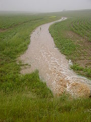
. It is generally installed in the thalweg
Thalweg
Thalweg in geography and fluvial geomorphology signifies the deepest continuous inline within a valley or watercourse system.-Hydrology:In hydrological and fluvial landforms, the thalweg is a line drawn to join the lowest points along the entire length of a stream bed or valley in its downward...
, the deepest continuous line along a valley
Valley
In geology, a valley or dale is a depression with predominant extent in one direction. A very deep river valley may be called a canyon or gorge.The terms U-shaped and V-shaped are descriptive terms of geography to characterize the form of valleys...
or watercourse
Watercourse
A watercourse is any flowing body of water. These include rivers, streams, anabranches, and so forth.-See also:* physical geography* Environmental flow* Waterway* Hydrology* Wadi-External links:...
, of a cultivated dry valley in order to control erosion
Erosion
Erosion is when materials are removed from the surface and changed into something else. It only works by hydraulic actions and transport of solids in the natural environment, and leads to the deposition of these materials elsewhere...
. A study carried out on a grassed waterway during 8 years in Bavaria
Bavaria
Bavaria, formally the Free State of Bavaria is a state of Germany, located in the southeast of Germany. With an area of , it is the largest state by area, forming almost 20% of the total land area of Germany...
showed that it can lead to several other types of positive impacts, e.g. on biodiversity
Biodiversity
Biodiversity is the degree of variation of life forms within a given ecosystem, biome, or an entire planet. Biodiversity is a measure of the health of ecosystems. Biodiversity is in part a function of climate. In terrestrial habitats, tropical regions are typically rich whereas polar regions...
.
Distinctions
Confusion between "grassed waterways" and "vegetative filter strips" should be avoided. The latter are generally narrower (only a few meters-wide) and rather installed along rivers as well as along or within cultivated fields. However Buffer stripBuffer strip
A buffer strip is an area of land maintained in permanent vegetation that helps to control air, soil, and water quality, along with other environmental problems, dealing primarily on land that is used in agriculture. Buffer strips trap sediment, and enhance filtration of nutrients and pesticides by...
can be a synonym
Synonym
Synonyms are different words with almost identical or similar meanings. Words that are synonyms are said to be synonymous, and the state of being a synonym is called synonymy. The word comes from Ancient Greek syn and onoma . The words car and automobile are synonyms...
, with shrubs and trees added to the plant component, as does a Riparian zone
Riparian zone
A riparian zone or riparian area is the interface between land and a river or stream. Riparian is also the proper nomenclature for one of the fifteen terrestrial biomes of the earth. Plant habitats and communities along the river margins and banks are called riparian vegetation, characterized by...
.
Runoff/erosion mitigation
Surface runoff
Surface runoff is the water flow that occurs when soil is infiltrated to full capacity and excess water from rain, meltwater, or other sources flows over the land. This is a major component of the water cycle. Runoff that occurs on surfaces before reaching a channel is also called a nonpoint source...
generated on cropland during storms or long winter rains concentrates in the thalweg
Thalweg
Thalweg in geography and fluvial geomorphology signifies the deepest continuous inline within a valley or watercourse system.-Hydrology:In hydrological and fluvial landforms, the thalweg is a line drawn to join the lowest points along the entire length of a stream bed or valley in its downward...
where it can lead to rill or gully
Gully
A gully is a landform created by running water, eroding sharply into soil, typically on a hillside. Gullies resemble large ditches or small valleys, but are metres to tens of metres in depth and width...
erosion.
Rills and gullies further concentrate runoff and speed up its transfer, which can worsen damage occurring downstream. This can result in a muddy flood
Muddy flood
A muddy flood is produced by an accumulation of runoff generated on cropland. Sediments are then detached by runoff and carried as suspended matter or bedload...
.
In this context, a grassed waterway allows increasing soil cohesion and roughness. It also prevents the formation of rills and gullies. Furthermore, it can slow down runoff and allow its re-infiltration during long winter rains. In contrast, its infiltration capacity is generally not sufficient to reinfiltrate runoff produced by heavy spring and summer storms. It can therefore be useful to combine it with extra measures, like the installation of earthen dams across the grassed waterway, in order to buffer runoff temporarily.