
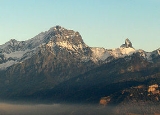
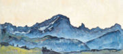
Grand Muveran
Encyclopedia
The Grand Muveran is a mountain
in the Bernese Alps
. At 3,051 metres it is the highest summit lying west of Pas de Cheville
and the westernmost three-thousander
of the Bernese Alps. It is located on the border between Vaud
and Valais
. On the latter side is the village of Ovronnaz
where the easiest route to the summit starts, via the Rambert Hut.
Mountain
Image:Himalaya_annotated.jpg|thumb|right|The Himalayan mountain range with Mount Everestrect 58 14 160 49 Chomo Lonzorect 200 28 335 52 Makalurect 378 24 566 45 Mount Everestrect 188 581 920 656 Tibetan Plateaurect 250 406 340 427 Rong River...
in the Bernese Alps
Bernese Alps
The Bernese Alps are a group of mountain ranges in the western part of the Alps, in Switzerland. Although the name suggests that they are located in the Bernese Oberland region of the canton of Bern, portions of the Bernese Alps are in the adjacent cantons of Valais, Lucerne, Obwalden, Fribourg and...
. At 3,051 metres it is the highest summit lying west of Pas de Cheville
Pas de Cheville
The Pas de Cheville is a high mountain pass across the western Bernese Alps, connecting Gryon in the canton of Vaud in Switzerland and Derborence in the canton of Valais....
and the westernmost three-thousander
Three-thousander
Three-thousanders are mountains with a height of between 3,000, but less than 4,000 metres above sea level. Similar terms are commonly used for mountains of other height brackets e. g...
of the Bernese Alps. It is located on the border between Vaud
Vaud
Vaud is one of the 26 cantons of Switzerland and is located in Romandy, the French-speaking southwestern part of the country. The capital is Lausanne. The name of the Canton in Switzerland's other languages are Vaud in Italian , Waadt in German , and Vad in Romansh.-History:Along the lakes,...
and Valais
Valais
The Valais is one of the 26 cantons of Switzerland in the southwestern part of the country, around the valley of the Rhône from its headwaters to Lake Geneva, separating the Pennine Alps from the Bernese Alps. The canton is one of the drier parts of Switzerland in its central Rhône valley...
. On the latter side is the village of Ovronnaz
Ovronnaz
Ovronnaz is a village located in the canton of Valais, Switzerland. It lies in the municipality of Leytron, close to Martigny.The village is located on the south side of the Bernese Alps, on a terrace above the Rhone river, at an altitude of 1,330 metres...
where the easiest route to the summit starts, via the Rambert Hut.