
Gmina Konopnica, Lublin Voivodeship
Encyclopedia
Gmina Konopnica is a rural gmina
(administrative district) in Lublin County
, Lublin Voivodeship
, in eastern Poland
. Its seat is the village of Konopnica
, which lies approximately 20 kilometres (12 mi) west of the regional capital Lublin
.
The gmina covers an area of 92.75 square kilometres (35.8 sq mi), and as of 2006 its total population is 11,001.
Konopnica is a suburban borough of Lublin, some 10 km to the south west of the town. When driving from the town you can see the changes on the landscape from an urban agglomeration, through estates of singlefamily houses and, finally, to the typically Polish countryside of golden fields and green meadows.
The borough of Konopnica is made up of 20 villages and hamlets in which, within an area of 92.75 km2, live over 10 000 people. Half of the inhabitants live off farming almost three-guarters of the land in the borough is agricultural. Mainly cereals and sugar beet are grown. Fruit growing is rapidly. The location provides good conditions for development of trade and services. A good road network ensures good communications with Lublin. The Lublin-Warsaw railway line, which runs through the borough, increases the transportation possibilities.
The railway runs along the border between two distinct geographical areas. The area to the north of railway line on the Nałęczowski Plateau which is characterised by a richly sculpted terrain.
In this part of the borough can be found the highest point in the Lublin, at a height of 252 m above sea level, and a network of picturesque loess ravines.
Stretching away on the other side of the railway line is the Bełżycka Plain. The flat quiet scenery of large fields and meadows reveals the most distant corners of the borough.
There are two large forests in the borough at Radawiec Duży and Tereszyn, as well as some smaller woods with a total area of over 5 km². The unpolluted natural environment and the beautiful scenery present ideal conditions for trip out of town.
 Slav settlements existed in this area in the early Middle Ages. Archaeological digs carried out in the 1980s confirm this.
During the first half of the 14th century Motycz was one of the more important places in the Lublin area, laying on the main trading route to Russia, while during the second half of the 14th century, that role was being fulfilled by Konopnica. The first reports about the place are from 1342 - Konopnica was at that time a royal village and its today is reflected in the borough's coat of arms.
In 1400 the chronicles of Jan Długosz mention the church at "Conopnicza" it was a wooden temple dedicated to St. Katarzyna. Today in its place stants a brick-built church dating back the beginning of the 20th century.
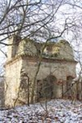
The rich history of the borough is also reflected by places such as the Swedish military cemetery in Motycz Leśny; "Castle Hill" in Motycz or the lime tree under which Napoleon rested during his march on Russia. The place and the park in Motycz have also been preserved, as well as a fragment of the place park in Radawiec. The railway station in Motycz, which is over 100 years old, is listed in the register of historic buildings.
and by the gminas of Bełżyce, Jastków
, Niedrzwica Duża
and Wojciechów
.
Gmina
The gmina is the principal unit of administrative division of Poland at its lowest uniform level. It is often translated as "commune" or "municipality." As of 2010 there were 2,479 gminas throughout the country...
(administrative district) in Lublin County
Lublin County
Lublin County is a unit of territorial administration and local government in Lublin Voivodeship, eastern Poland. It came into being on January 1, 1999, as a result of the Polish local government reforms passed in 1998. Its administrative seat is the city of Lublin, although the city is not part...
, Lublin Voivodeship
Lublin Voivodeship
- Administrative division :Lublin Voivodeship is divided into 24 counties : 4 city counties and 20 land counties. These are further divided into 213 gminas....
, in eastern Poland
Poland
Poland , officially the Republic of Poland , is a country in Central Europe bordered by Germany to the west; the Czech Republic and Slovakia to the south; Ukraine, Belarus and Lithuania to the east; and the Baltic Sea and Kaliningrad Oblast, a Russian exclave, to the north...
. Its seat is the village of Konopnica
Konopnica, Lublin Voivodeship
Konopnica is a village in Lublin County, Lublin Voivodeship, in eastern Poland. It is the seat of the gmina called Gmina Konopnica. It lies approximately west of the regional capital Lublin.The village has a population of 740....
, which lies approximately 20 kilometres (12 mi) west of the regional capital Lublin
Lublin
Lublin is the ninth largest city in Poland. It is the capital of Lublin Voivodeship with a population of 350,392 . Lublin is also the largest Polish city east of the Vistula river...
.
The gmina covers an area of 92.75 square kilometres (35.8 sq mi), and as of 2006 its total population is 11,001.
Konopnica is a suburban borough of Lublin, some 10 km to the south west of the town. When driving from the town you can see the changes on the landscape from an urban agglomeration, through estates of singlefamily houses and, finally, to the typically Polish countryside of golden fields and green meadows.
The borough of Konopnica is made up of 20 villages and hamlets in which, within an area of 92.75 km2, live over 10 000 people. Half of the inhabitants live off farming almost three-guarters of the land in the borough is agricultural. Mainly cereals and sugar beet are grown. Fruit growing is rapidly. The location provides good conditions for development of trade and services. A good road network ensures good communications with Lublin. The Lublin-Warsaw railway line, which runs through the borough, increases the transportation possibilities.
The railway runs along the border between two distinct geographical areas. The area to the north of railway line on the Nałęczowski Plateau which is characterised by a richly sculpted terrain.
In this part of the borough can be found the highest point in the Lublin, at a height of 252 m above sea level, and a network of picturesque loess ravines.
Stretching away on the other side of the railway line is the Bełżycka Plain. The flat quiet scenery of large fields and meadows reveals the most distant corners of the borough.
There are two large forests in the borough at Radawiec Duży and Tereszyn, as well as some smaller woods with a total area of over 5 km². The unpolluted natural environment and the beautiful scenery present ideal conditions for trip out of town.
History
During the first half of the 14th century Motycz was one of the more important places in the Lublin area, laying on the main trading route to Russia, while during the second half of the 14th century, that role was being fulfilled by Konopnica. The first reports about the place are from 1342 - Konopnica was at that time a royal village and its today is reflected in the borough's coat of arms.
In 1400 the chronicles of Jan Długosz mention the church at "Conopnicza" it was a wooden temple dedicated to St. Katarzyna. Today in its place stants a brick-built church dating back the beginning of the 20th century.
The rich history of the borough is also reflected by places such as the Swedish military cemetery in Motycz Leśny; "Castle Hill" in Motycz or the lime tree under which Napoleon rested during his march on Russia. The place and the park in Motycz have also been preserved, as well as a fragment of the place park in Radawiec. The railway station in Motycz, which is over 100 years old, is listed in the register of historic buildings.
Neighbouring gminas
Gmina Konopnica is bordered by the city of LublinLublin
Lublin is the ninth largest city in Poland. It is the capital of Lublin Voivodeship with a population of 350,392 . Lublin is also the largest Polish city east of the Vistula river...
and by the gminas of Bełżyce, Jastków
Gmina Jastków
Gmina Jastków is a rural gmina in Lublin County, Lublin Voivodeship, in eastern Poland. Its seat is the village of Jastków, which lies approximately north-west of the regional capital Lublin....
, Niedrzwica Duża
Gmina Niedrzwica Duza
Gmina Niedrzwica Duża is a rural gmina in Lublin County, Lublin Voivodeship, in eastern Poland. Its seat is the village of Niedrzwica Duża, which lies approximately south-west of the regional capital Lublin....
and Wojciechów
Gmina Wojciechów
Gmina Wojciechów is a rural gmina in Lublin County, Lublin Voivodeship, in eastern Poland. Its seat is the village of Wojciechów, which lies approximately west of the regional capital Lublin....
.