
Glymur
Encyclopedia
The waterfall
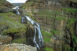
Glymur, with a cascade of 196 m, is the highest waterfall of Iceland
.
It is situated at the rear end of the Hvalfjörður
. Since the opening of the tunnel under this fjord
, most people bypass the area. However, it is a very beautiful part of the country with volcano
es and tree plantations.
The river Botnsá leaves the lake Hvalvatn
and after a short distance the water falls down alongside the volcano Hvalfell into a canyon with green moss. The waterfall can be accessed from Botnsá, a small village of summerhouses named after the river. From the Botnsá parking area, one can hike up part of the mountain (350 m) on marked hiking paths. To get a better view of the waterfall it is necessary to see it from the south side of the river Botnsá, however the south side trail is strenuous and potential hazardous, passing along the adges of steep dropoffs.
From the parking area, both trails begin by passing through a gate and walking up a dirt road. The easier north side trail continues up the dirt road and is marked by rocks blazed with yellow paint. A few hundred meters up the road, the south side trail (also marked by yellow rocks) branches off to the right. This trail first becomes difficult when it drops over a small cliff face and descends through a cave down to the river. In the summer there is a small pole over the river with an adjacent cable for a handhold, where travellers can cross to the southern side.
After crossing the river, the south trail climbs steeply with various muddy, rocky and loose areas. At times it skirts steep dropoffs. About 3/4 way up this trail passes a small side waterfall with a sheltered pool. Hikers often stop here to refresh themselves; this point is a milestone only a short distance below the viewing area. Anyone attempting this trail should have proper boots, water, and preferably hiking poles though many people hike without poles. The south trail is a strenuous but non-technical climb rather than a mere walk.
Waterfall
A waterfall is a place where flowing water rapidly drops in elevation as it flows over a steep region or a cliff.-Formation:Waterfalls are commonly formed when a river is young. At these times the channel is often narrow and deep. When the river courses over resistant bedrock, erosion happens...
Glymur, with a cascade of 196 m, is the highest waterfall of Iceland
Iceland
Iceland , described as the Republic of Iceland, is a Nordic and European island country in the North Atlantic Ocean, on the Mid-Atlantic Ridge. Iceland also refers to the main island of the country, which contains almost all the population and almost all the land area. The country has a population...
.
It is situated at the rear end of the Hvalfjörður
Hvalfjörður
Hvalfjörður is situated in the west of Iceland between Mosfellsbær and Akranes. The fjord is approximately 30 km long and 5 km wide....
. Since the opening of the tunnel under this fjord
Fjord
Geologically, a fjord is a long, narrow inlet with steep sides or cliffs, created in a valley carved by glacial activity.-Formation:A fjord is formed when a glacier cuts a U-shaped valley by abrasion of the surrounding bedrock. Glacial melting is accompanied by rebound of Earth's crust as the ice...
, most people bypass the area. However, it is a very beautiful part of the country with volcano
Volcano
2. Bedrock3. Conduit 4. Base5. Sill6. Dike7. Layers of ash emitted by the volcano8. Flank| 9. Layers of lava emitted by the volcano10. Throat11. Parasitic cone12. Lava flow13. Vent14. Crater15...
es and tree plantations.
The river Botnsá leaves the lake Hvalvatn
Hvalvatn
The lake Hvalvatn is situated some kilometers to the east of Hvalfjörður in the western portion of Iceland. It lies to the east of the volcano Hvalfell. The surface measures 4.1 km², and its greatest depth is 180 m....
and after a short distance the water falls down alongside the volcano Hvalfell into a canyon with green moss. The waterfall can be accessed from Botnsá, a small village of summerhouses named after the river. From the Botnsá parking area, one can hike up part of the mountain (350 m) on marked hiking paths. To get a better view of the waterfall it is necessary to see it from the south side of the river Botnsá, however the south side trail is strenuous and potential hazardous, passing along the adges of steep dropoffs.
From the parking area, both trails begin by passing through a gate and walking up a dirt road. The easier north side trail continues up the dirt road and is marked by rocks blazed with yellow paint. A few hundred meters up the road, the south side trail (also marked by yellow rocks) branches off to the right. This trail first becomes difficult when it drops over a small cliff face and descends through a cave down to the river. In the summer there is a small pole over the river with an adjacent cable for a handhold, where travellers can cross to the southern side.
After crossing the river, the south trail climbs steeply with various muddy, rocky and loose areas. At times it skirts steep dropoffs. About 3/4 way up this trail passes a small side waterfall with a sheltered pool. Hikers often stop here to refresh themselves; this point is a milestone only a short distance below the viewing area. Anyone attempting this trail should have proper boots, water, and preferably hiking poles though many people hike without poles. The south trail is a strenuous but non-technical climb rather than a mere walk.