

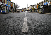
Gloucester Road, Bristol
Encyclopedia
A38 road
The A38, part of which is also known as the Devon Expressway, is a major A-class trunk road in England.The road runs from Bodmin in Cornwall to Mansfield in Nottinghamshire. It is long, making it one of the longest A-roads in England. It was formerly known as the Leeds — Exeter Trunk Road,...
in north Bristol
Bristol
Bristol is a city, unitary authority area and ceremonial county in South West England, with an estimated population of 433,100 for the unitary authority in 2009, and a surrounding Larger Urban Zone with an estimated 1,070,000 residents in 2007...
that runs through the suburbs of St. Andrews, Bishopston
Bishopston, Bristol
Bishopston the name of both a council ward of the city of Bristol, England, and a suburb of the city that falls within that ward. Bishopston is situated around the Gloucester Road , the main northern arterial road in the city. The ward includes St Bonaventures and Ashley Down parishes, as well as...
and Horfield
Horfield
Horfield is a suburb of the city of Bristol, in southwest England. It lies on Bristol's northern edge, its border with Filton marking part of the boundary between Bristol and South Gloucestershire. Bishopston lies directly to the south. Monks Park and Golden Hill are to the west. Lockleaze and...
. It was originally called Horfield Road.
It starts at the junction with Cheltenham Road, Zetland Road and Elton Road. Cheltenham Road is spanned by a railway viaduct (known locally as "the Arches") carrying the Severn Beach Line
Severn Beach Line
The Severn Beach Line is a local railway in Bristol, UK. It runs from Narroways Hill Junction to Severn Beach, and is the successor to the Bristol Port Railway and Pier, which ran from a Bristol terminus in the Avon Gorge to a station and pier on the Severn Estuary.Passenger trains run from Bristol...
. This is often mistakenly taken as the start of Gloucester Road, however the first property on Gloucester Road (1-3) is the Maplin
Maplin Electronics
Maplin Electronics is a retailer of electronic goods in the UK and Ireland. As of December 2010, there are 180 Maplin Electronics stores in the United Kingdom...
electronics shop. The difference between the two roads is further emphasised by the fact that Gloucester Road has the postal code
Postal code
A postal code is a series of letters and/or digits appended to a postal address for the purpose of sorting mail. Once postal codes were introduced, other applications became possible.In February 2005, 117 of the 190 member countries of the Universal Postal Union had postal code systems...
of BS7
BS postcode area
The BS postcode area, also known as the Bristol postcode area, is a group of postcode districts around Axbridge, Banwell, Bristol, Cheddar, Clevedon, Wedmore, Weston-super-Mare and Winscombe in England.-Coverage:...
whilst Cheltenham Road is BS6
BS postcode area
The BS postcode area, also known as the Bristol postcode area, is a group of postcode districts around Axbridge, Banwell, Bristol, Cheddar, Clevedon, Wedmore, Weston-super-Mare and Winscombe in England.-Coverage:...
.
The road continues through the outer suburbs, temporarily becoming Filton Road, then Gloucester Road North (and becoming a dual carriageway), before reverting to "Gloucester Road" shortly after passing Filton Airport and the Royal Mail
Royal Mail
Royal Mail is the government-owned postal service in the United Kingdom. Royal Mail Holdings plc owns Royal Mail Group Limited, which in turn operates the brands Royal Mail and Parcelforce Worldwide...
Sorting Office on a flyover. Between Filton Road and Gloucester Road North it passes into South Gloucestershire
South Gloucestershire
South Gloucestershire is a unitary district in the ceremonial county of Gloucestershire, in South West England.-History:The district was created in 1996, when the county of Avon was abolished, by the merger of former area of the districts of Kingswood and Northavon...
.
The road bypasses Patchway
Patchway
Patchway is a town in South Gloucestershire, England, situated northwest of central Bristol. The town is a housing overflow for Bristol being contiguous to Bristol's urban area, and is often regarded as a large outer suburb. Nearby are the other Bristol satellite towns of Filton and Bradley Stoke....
and Bradley Stoke
Bradley Stoke
Bradley Stoke is a dormitory town/suburb in South Gloucestershire, England, situated on the north side of the city of Bristol. Named after the local Bradley Brook and Stoke Brook streams, the town was planned in the 1970s and building began in 1987...
, then increases in capacity to six-lane dual carriageway as it transfers Aztec West
Aztec West
Aztec West is a business park in South Gloucestershire, England, situated at the northern fringes of Greater Bristol, near Bradley Stoke and Patchway. It is close to the M4 and M5 motorways and the Almondsbury Interchange. Adjacent is the A38 trunk road....
traffic to and from the M5
M5 motorway
The M5 is a motorway in England. It runs from a junction with the M6 at West Bromwich near Birmingham to Exeter in Devon. Heading south-west, the M5 runs east of West Bromwich and west of Birmingham through Sandwell Valley...
. It changes back to single carriageway as it passes through Almondsbury
Almondsbury
Almondsbury is a large village near junction 16 of the M5 motorway, in South Gloucestershire, England.-Description:The village is split by a steep hill, part of the escarpment overlooking the Severn floodplain. At the bottom of the hill is Lower Almondsbury where a pub and hotel, The Bowl Inn, is...
, and from there passes Alveston
Alveston
Alveston is a commuter village of roughly 3000 people about south of Thornbury, South Gloucestershire and approximately north of Bristol, England. Alveston is twinned with Courville sur Eure, France. It has two hotels, a variety of small shops, several parks and fields, two churches and a...
and Thornbury
Thornbury, South Gloucestershire
Thornbury is a market town in South Gloucestershire, England, approximately 12 miles north of the city of Bristol, with a population of 12,342 at the 2001 UK census. The town hosts South Gloucestershire Council headquarters and is twinned with Bockenem in Germany. Thornbury is a Britain in Bloom...
on its way to Gloucester
Gloucester
Gloucester is a city, district and county town of Gloucestershire in the South West region of England. Gloucester lies close to the Welsh border, and on the River Severn, approximately north-east of Bristol, and south-southwest of Birmingham....
.
Gloucester Road also has the largest number of independent traders on any one road in the UK. To support them Gloucester Road Traders associated was set up. Snap2 in conjunction with The Gloucester Road Traders Association formed gloucester-rd.co.uk which is proactive in providing information for businesses, residents and visitors to the Gloucester Road.