
Georgia State Route 32
Encyclopedia
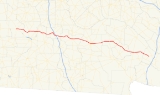
State Route 32 is a west–east state route located in the southern part of the U.S. state
of Georgia
. The route travels from SR 520 in Dawson east to SR 99
west of Sterling.
, where it is briefly cosigned
with U.S. 19
/SR 3. The route continues east from Leesburg to Ashburn
, where it becomes cosigned with State Route 112, then US 41
/SR 7. South of Ashburn, SR 32 departs US 41/SR 7 and continues east. It serves as exit 78 for Interstate 75
southeast of Ashburn, then continues east. The route cosigns with SR 125 for several miles before arriving in Ocilla
. The route continues east from Ocilla, passing through Douglas
, Alma
, and sparsely populated areas in the southeast portion of the state before arriving at its eastern terminus at SR 99 west of Sterling.
A largely rural route, State Route 32 sees only minor traffic except around Douglas. Much of the route sees an Annual Average Daily Traffic
of 10,000 vehicles or less.
U.S. state
A U.S. state is any one of the 50 federated states of the United States of America that share sovereignty with the federal government. Because of this shared sovereignty, an American is a citizen both of the federal entity and of his or her state of domicile. Four states use the official title of...
of Georgia
Georgia (U.S. state)
Georgia is a state located in the southeastern United States. It was established in 1732, the last of the original Thirteen Colonies. The state is named after King George II of Great Britain. Georgia was the fourth state to ratify the United States Constitution, on January 2, 1788...
. The route travels from SR 520 in Dawson east to SR 99
Georgia State Route 99
State Route 99 is a state highway located in southeast Georgia in Glynn County and McIntosh County. It roughly follows an old Indian trading trail....
west of Sterling.
Route description
From its western terminus in Dawson at SR 520, State Route 32 runs east to LeesburgLeesburg, Georgia
Leesburg is a city in Lee County, Georgia, United States. The population was 2,965 at the 2009 census estimate. The city is the county seat of Lee County.Leesburg is part of the Albany, Georgia Metropolitan Statistical Area.-Geography:...
, where it is briefly cosigned
Concurrency (road)
A concurrency, overlap, or coincidence in a road network is an instance of one physical road bearing two or more different highway, motorway, or other route numbers...
with U.S. 19
U.S. Route 19
U.S. Route 19 is a north–south U.S. Highway. Despite encroaching Interstate Highways, the route has remained a long-haul route, connecting the Gulf of Mexico with Lake Erie....
/SR 3. The route continues east from Leesburg to Ashburn
Ashburn, Georgia
Ashburn is a city in, and the county seat of, Turner County, Georgia, United States. The population was 4,419 at the 2000 census.The 2007 Census Estimate shows a population of 9,898. Ashburn's government is classified as a "council/manager" form of municipal government. The City Manager of Ashburn...
, where it becomes cosigned with State Route 112, then US 41
U.S. Route 41
U.S. Route 41 is a north–south United States Highway that runs from Miami, Florida to the Upper Peninsula of Michigan. Until 1949, the part in southern Florida, from Naples to Miami, was U.S...
/SR 7. South of Ashburn, SR 32 departs US 41/SR 7 and continues east. It serves as exit 78 for Interstate 75
Interstate 75
Interstate 75 is a major north–south Interstate Highway in the Great Lakes and Southeastern regions of the United States. It travels from State Road 826 and State Road 924 in Hialeah, Florida to Sault Ste. Marie, Michigan, at the Ontario, Canada, border...
southeast of Ashburn, then continues east. The route cosigns with SR 125 for several miles before arriving in Ocilla
Ocilla, Georgia
Ocilla is a city in Irwin County, Georgia, United States. The population was 3,270 at the 2000 census. The city is the county seat of Irwin County.Ocilla is part of the Fitzgerald Micropolitan Statistical Area.-Geography:...
. The route continues east from Ocilla, passing through Douglas
Douglas, Georgia
Douglas is a city in Coffee County, Georgia, United States. As of the 2010 census, the city had a population of 11,589. Douglas is the county seat of Coffee County and the core city of the Douglas, Georgia Micropolitan Statistical Area which has a population of 48,708 as of the 2008 census...
, Alma
Alma, Georgia
Alma is a city in Bacon County, Georgia, United States. The population was 3,236 at the 2000 census. The city is the county seat of Bacon County...
, and sparsely populated areas in the southeast portion of the state before arriving at its eastern terminus at SR 99 west of Sterling.
A largely rural route, State Route 32 sees only minor traffic except around Douglas. Much of the route sees an Annual Average Daily Traffic
Annual average daily traffic
Average Annual daily traffic, abbreviated AADT, is a measure used primarily in transportation planning and transportation engineering. It is the total volume of vehicle traffic of a highway or road for a year divided by 365 days. AADT is a useful and simple measurement of how busy the road is...
of 10,000 vehicles or less.