
Georgia State Route 284
Encyclopedia
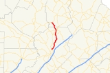
State Route 284 is a north–south state route located entirely in the northeastern part of the U.S. state
of Georgia
. From the route's southern terminus at State Route 11 Business just west of U.S. Route 129
/State Route 11 north of Gainesville
, the route runs north, crossing the Chattahoochee River
arm of Lake Lanier
. The route continues north from Hall County
and into White County
to Clermont
, then continues north-northwest to its northern terminus at State Route 115.
U.S. state
A U.S. state is any one of the 50 federated states of the United States of America that share sovereignty with the federal government. Because of this shared sovereignty, an American is a citizen both of the federal entity and of his or her state of domicile. Four states use the official title of...
of Georgia
Georgia (U.S. state)
Georgia is a state located in the southeastern United States. It was established in 1732, the last of the original Thirteen Colonies. The state is named after King George II of Great Britain. Georgia was the fourth state to ratify the United States Constitution, on January 2, 1788...
. From the route's southern terminus at State Route 11 Business just west of U.S. Route 129
U.S. Route 129
U.S. Route 129 is an offshoot route of U.S. Route 29, which it intersects near Athens, Georgia. US 129 currently runs for 582 miles from Knoxville, Tennessee, to Chiefland, Florida, at U.S. Route 19 and U.S. Route 98. It passes through the states of Tennessee, North Carolina, Georgia and Florida...
/State Route 11 north of Gainesville
Gainesville, Georgia
-Severe Weather:Gainesville sits on the very fringe of Tornado Alley, a region of the United States where severe weather is common. Supercell thunderstorms can sweep through any time between March and November, but are concentrated most in the spring...
, the route runs north, crossing the Chattahoochee River
Chattahoochee River
The Chattahoochee River flows through or along the borders of the U.S. states of Georgia, Alabama, and Florida. It is a tributary of the Apalachicola River, a relatively short river formed by the confluence of the Chattahoochee and Flint Rivers and emptying into Apalachicola Bay in the Gulf of...
arm of Lake Lanier
Lake Lanier
Lake Lanier is a reservoir in the northern portion of the U.S. state of Georgia. It was created by the completion of Buford Dam on the Chattahoochee River in 1956, and is also fed by the waters of the Chestatee River. The lake encompasses of water, and of shoreline at normal level, a "full...
. The route continues north from Hall County
Hall County, Georgia
Hall County is a county located in the U.S. state of Georgia. In 2000, the population was 139,277. It is included in the Gainesville, Georgia, Metropolitan Statistical Area...
and into White County
White County, Georgia
White County is a county located in the northeast corner of the U.S. state of Georgia. It was created on December 22, 1857, from part of Habersham County. The county was named for Newton County Representative David T. White, who helped a Habersham representative successfully attain passage of an...
to Clermont
Clermont, Georgia
Clermont is a town in Hall County, Georgia, United States. The population was 419 at the 2000 census. It is part of the Gainesville, GA Metropolitan Statistical Area.-Geography:Clermont is located at ....
, then continues north-northwest to its northern terminus at State Route 115.