
Georgia State Route 26
Encyclopedia
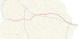
State Route 26 is a west–east state route located in the central part of the U.S. state
of Georgia
. The route travels from U.S. 27/U.S. 280
/S.R. 1/S.R. 520 in Fort Benning
east to Tybee Island.
, and passing through the towns of Buena Vista
and Ellaville
. State Route 26 serves as exit 127 for Interstate 75
, before continuing east to Hawkinsville
. In Hawkinsville, S.R. 26 becomes cosigned
with U.S. Route 129 Alternate and State Route 112, and the three routes travel northeast to Cochran
. In Cochran, S.R. 26 departs the two routes and continues northeast, serving as exit 39 for Interstate 16
before intersecting U.S. 80
west of Dudley
. At the intersection, S.R. 26 continues east, cosigned with U.S. 80 and S.R. 19. In Dublin
, S.R. 19 departs to the south, and after a brief cosignage with U.S. 319
/S.R. 31, U.S. 80 and S.R. 26 continue east, passing through Swainsboro
and Statesboro
, continuing to Savannah
. In Savannah, the two routes briefly cosign with Interstate 516
, then continue east, crossing the coastal marshes to Tybee Island, where both S.R. 26 and U.S. 80 meet their eastern terminus.
SR 26 is largely a rural highway, and as such, sees an Average Annual Daily Traffic of 5,000 vehicles or less, except around cities such as Dublin, Statesboro, and Savannah.
U.S. state
A U.S. state is any one of the 50 federated states of the United States of America that share sovereignty with the federal government. Because of this shared sovereignty, an American is a citizen both of the federal entity and of his or her state of domicile. Four states use the official title of...
of Georgia
Georgia (U.S. state)
Georgia is a state located in the southeastern United States. It was established in 1732, the last of the original Thirteen Colonies. The state is named after King George II of Great Britain. Georgia was the fourth state to ratify the United States Constitution, on January 2, 1788...
. The route travels from U.S. 27/U.S. 280
U.S. Route 280
U.S. Route 280 is a spur of U.S. Highway 80. It currently runs for 392 miles from Blichton, Georgia at U.S. Highway 80 to Birmingham, Alabama at I-20/I-59. For much of its route, U.S. 280 travels through rural areas and smaller cities in southern Georgia and east central Alabama. Once the...
/S.R. 1/S.R. 520 in Fort Benning
Fort Benning
Fort Benning is a United States Army post located southeast of the city of Columbus in Muscogee and Chattahoochee counties in Georgia and Russell County, Alabama...
east to Tybee Island.
Route description
State Route 26 begins in Fort Benning at U.S. 27/U.S. 280/S.R. 1/S.R. 520. The route travels east, passing to the north of CussetaCusseta, Georgia
Cusseta-Chattahoochee County is unified city-county in Georgia, United States. It is part of the Columbus, Georgia-Alabama Metropolitan Statistical Area. The population was 1,196 at the 2000 Census..-History:...
, and passing through the towns of Buena Vista
Buena Vista, Georgia
Buena Vista is a city in Marion County, Georgia, United States. It is part of the Columbus, Georgia-Alabama Metropolitan Statistical Area. The population was 1,664 at the 2000 census. The city is the county seat of Marion County. It is the birthplace of Congressional Medal of Honor recipient Luther...
and Ellaville
Ellaville, Georgia
Ellaville is a city in Schley County, Georgia, United States. The population was 1,609 at the 2000 census. The city is the county seat of Schley County.Ellaville is part of the Americus Micropolitan Statistical Area.-Geography:...
. State Route 26 serves as exit 127 for Interstate 75
Interstate 75
Interstate 75 is a major north–south Interstate Highway in the Great Lakes and Southeastern regions of the United States. It travels from State Road 826 and State Road 924 in Hialeah, Florida to Sault Ste. Marie, Michigan, at the Ontario, Canada, border...
, before continuing east to Hawkinsville
Hawkinsville, Georgia
Hawkinsville is a city in Pulaski County, Georgia, United States. The population was 7,487 at the 2010 census. The city is the county seat of Pulaski County.-Geography:Hawkinsville is located at ....
. In Hawkinsville, S.R. 26 becomes cosigned
Concurrency (road)
A concurrency, overlap, or coincidence in a road network is an instance of one physical road bearing two or more different highway, motorway, or other route numbers...
with U.S. Route 129 Alternate and State Route 112, and the three routes travel northeast to Cochran
Cochran, Georgia
Cochran is a city in Bleckley County, Georgia, United States. As of the 2010 census, the city had a population of 5,150. The city is the county seat of Bleckley County.- History :...
. In Cochran, S.R. 26 departs the two routes and continues northeast, serving as exit 39 for Interstate 16
Interstate 16
Interstate 16 , also known as Jim Gillis Historic Savannah Parkway or State Route 404 , is an intrastate Interstate Highway located entirely within the state of Georgia, United States...
before intersecting U.S. 80
U.S. Route 80
U.S. Route 80 is an east–west United States highway, much of which was once part of the early auto trail known as the Dixie Overland Highway. As the "0" in the route number indicates, it was originally a cross-country route, from the Atlantic to the Pacific...
west of Dudley
Dudley, Georgia
Dudley is a city in Laurens County, Georgia, United States. The population was 447 at the 2000 census. It is part of the Dublin Micropolitan Statistical Area.- Geography :Dudley is located at ....
. At the intersection, S.R. 26 continues east, cosigned with U.S. 80 and S.R. 19. In Dublin
Dublin, Georgia
Dublin is a city in Laurens County, Georgia, United States. As of the 2010 census, the city had a population of 16,201. The city is the county seat of Laurens County.-History:The original settlement was named after the city Dublin, Ireland....
, S.R. 19 departs to the south, and after a brief cosignage with U.S. 319
U.S. Route 319
U.S. Highway 319 is a spur of U.S. Route 19. It runs for 318 miles from US 1 /State Route 4 in Wadley, Georgia to the John Gorrie Bridge at Apalachicola, Florida. The sections of US 319 in Medart, Florida and from just east of Carrabelle, Florida to its terminus in Apalachicola are jointly...
/S.R. 31, U.S. 80 and S.R. 26 continue east, passing through Swainsboro
Swainsboro, Georgia
Swainsboro is a city located in Emanuel County, Georgia. As of the 2000 census, the city had a total population of 6,943. The city is the county seat of Emanuel County.-Geography:...
and Statesboro
Statesboro, Georgia
Statesboro is a city in southeast Georgia, United States, and is the county seat and most populous city of Bulloch County. Statesboro has a population of 28,422 and the Statesboro, GA Micropolitan Statistical Area had a population of 70,217...
, continuing to Savannah
Savannah, Georgia
Savannah is the largest city and the county seat of Chatham County, in the U.S. state of Georgia. Established in 1733, the city of Savannah was the colonial capital of the Province of Georgia and later the first state capital of Georgia. Today Savannah is an industrial center and an important...
. In Savannah, the two routes briefly cosign with Interstate 516
Interstate 516
Interstate 516 is a 6.49-mile long auxiliary Interstate Highway near the southeastern, coastal Georgia city of Savannah as a spur route of Interstate 16. I-516 was formerly signed State Route 21 and even early as State Route 26 Loop...
, then continue east, crossing the coastal marshes to Tybee Island, where both S.R. 26 and U.S. 80 meet their eastern terminus.
SR 26 is largely a rural highway, and as such, sees an Average Annual Daily Traffic of 5,000 vehicles or less, except around cities such as Dublin, Statesboro, and Savannah.