
Georgia State Route 255
Encyclopedia
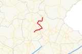
State Route 255 is a state route located in Habersham
and White
counties in the northeast part of the U.S. state
of Georgia
. The route crosses the Habersham/White County line three times. The highway starts east of Cleveland
and ends in Batesville
. In its central portion SR 255 has a 4.9 miles (7.9 km) overlap
with SR 17. The southern non-overlapped section of the highway is known locally as Blue Creek Road (7.2 miles) and the northern non-overlapped section as Stovall Mill Road (7.5 miles). Portions of the route are in the Chattahoochee National Forest.
SR 255 passes through the historic Sautee Valley
and by the Stovall Mill Covered Bridge
located over Chickamauga Creek (in White County).
Habersham County, Georgia
Habersham County is a county located in the U.S. state of Georgia. It was created on December 15, 1818, and named for Colonel Joseph Habersham. As of 2000, the population was 35,902. The 2007 Census Estimate shows a population of 42,272. Clarkesville is the county seat.Chartered in 1823, the...
and White
White County, Georgia
White County is a county located in the northeast corner of the U.S. state of Georgia. It was created on December 22, 1857, from part of Habersham County. The county was named for Newton County Representative David T. White, who helped a Habersham representative successfully attain passage of an...
counties in the northeast part of the U.S. state
U.S. state
A U.S. state is any one of the 50 federated states of the United States of America that share sovereignty with the federal government. Because of this shared sovereignty, an American is a citizen both of the federal entity and of his or her state of domicile. Four states use the official title of...
of Georgia
Georgia (U.S. state)
Georgia is a state located in the southeastern United States. It was established in 1732, the last of the original Thirteen Colonies. The state is named after King George II of Great Britain. Georgia was the fourth state to ratify the United States Constitution, on January 2, 1788...
. The route crosses the Habersham/White County line three times. The highway starts east of Cleveland
Cleveland, Georgia
Cleveland is a city in White County, Georgia, United States. The population was 1,907 at the 2000 census. The city is the county seat of White County....
and ends in Batesville
Batesville, Georgia
Batesville is a mountain community situated at the intersection of modern Georgia State Route 197 and 255 in the Northeast Georgia mountains of Habersham County. Located at an elevation of 1706 feet above mean sea level, the climate in Batesville is pleasant in summer with occasional snow in the...
. In its central portion SR 255 has a 4.9 miles (7.9 km) overlap
Concurrency (road)
A concurrency, overlap, or coincidence in a road network is an instance of one physical road bearing two or more different highway, motorway, or other route numbers...
with SR 17. The southern non-overlapped section of the highway is known locally as Blue Creek Road (7.2 miles) and the northern non-overlapped section as Stovall Mill Road (7.5 miles). Portions of the route are in the Chattahoochee National Forest.
SR 255 passes through the historic Sautee Valley
Sautee Valley Historic District
The Sautee Valley Historic District is a historic district centered on the community of Sautee Nacoochee in White County, Georgia. It was added to the National Register of Historical Places in 1986 and has agricultural, architectural and historic significance...
and by the Stovall Mill Covered Bridge
Stovall Mill Covered Bridge
The Stovall Mill Covered Bridge is the smallest covered bridge Georgia. Built in 1895, it is one span wide and 33 feet long and made of wood. It spans Chickamauga Creek in White County and is located near State Route 255. The bridge is currently owned by the White County Historical Society...
located over Chickamauga Creek (in White County).