

Georgia State Route 180
Encyclopedia
State Route 180 runs for about 26 miles (41.8 km) from SR 60 in Suches
to SR 17/75 halfway between Hiawassee
and Helen
in Union County
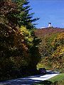
. SR 180 traverses some of the most difficult terrain in Georgia, traveling the gaps of the highest mountains in the state. The route has two sections known as Bald Mountain Road and Wolfpen Gap Road, which are joined by a 2.3 miles (3.7 km) overlap with U.S. 19/129 in the north of Vogel State Park
. Much of the highway is in the Chattahoochee National Forest.
Bald Mountain Road, named for the state's highest peak (Brasstown Bald
), is the eastern section of the highway and has been designated a National Scenic Byway
and a Georgia Scenic Byway. Included in this section is a junction with the Richard B. Russell Scenic Highway and part of SR 180 is included in the Russell-Brasstown Scenic Byway
. Bald Mountain Road crosses the Nottely River
shortly before the overlap with U.S. 19/129.
Wolfpen Gap Road (11.8-mile western section of the highway) is known to be the curviest road in the state. Sites along this section include various hiking trails and scenery as well as Vogel State Park, access to Sosebee Cove
, an intersection with the Coosa Back Country Trail, Lake Winfield Scott
(Georgia's highest lake) and Suches
, “The Valley Above The Clouds.” The highpoint of the highway is 3260 feet (993.6 m) at Wolfpen Gap.
 State Route 180 Spur is a 2.6 miles (4.2 km) route that connects SR 180 with a parking lot at the visitors center on Brasstown Bald
, the highest point in Georgia. It shares the National Scenic Byway
and Georgia Scenic Byway designations bestowed upon SR 180. Because of the altitude and steepness of the road, and because it serves no through traffic, it is often closed in winter due to inclement weather.
Suches, Georgia
Suches is an unincorporated area in Union County, Georgia, United States. With an altitude approaching 3,000 feet, Suches describes itself as "The Valley Above The Clouds"' and is one of the highest-elevation communities in the state. It is the birthplace of Arthur Woody, a forest ranger who was a...
to SR 17/75 halfway between Hiawassee
Hiawassee, Georgia
Hiawassee is a town in and the county seat of Towns County, Georgia, United States. The population was 810 at the 2000 census. Its name comes from the Cherokee word Ayuhwasi, which means a meadow.-Geography:...
and Helen
Helen, Georgia
Helen is a city located on the Chattahoochee River in White County in the north of the U.S. state of Georgia. As of the 2000 census, the city's population was 420.-History:...
in Union County
Union County, Georgia
Union County is a county located in the U.S. state of Georgia. As of 2000, the population was 17,289. The 2007 Census Estimate shows a population of 20,968. The county seat is Blairsville.Its Sole commissioner is Lamar Paris, who has served since 2001....
. SR 180 traverses some of the most difficult terrain in Georgia, traveling the gaps of the highest mountains in the state. The route has two sections known as Bald Mountain Road and Wolfpen Gap Road, which are joined by a 2.3 miles (3.7 km) overlap with U.S. 19/129 in the north of Vogel State Park
Vogel State Park
Vogel State Park is a or 94 hectares state park located at the base of Blood Mountain in the Chattahoochee National Forest. It became one of the first two parks in Georgia when it founded a state park system in 1931. Much of the park was constructed by the Civilian Conservation Corps during the...
. Much of the highway is in the Chattahoochee National Forest.
Bald Mountain Road, named for the state's highest peak (Brasstown Bald
Brasstown Bald
Brasstown Bald is the highest natural point in the state of Georgia, USA, with a summit elevation of 4,784 feet above mean sea level....
), is the eastern section of the highway and has been designated a National Scenic Byway
National Scenic Byway
A National Scenic Byway is a road recognized by the United States Department of Transportation for its archeological, cultural, historic, natural, recreational, and/or scenic qualities. The program was established by Congress in 1991 to preserve and protect the nation's scenic but often...
and a Georgia Scenic Byway. Included in this section is a junction with the Richard B. Russell Scenic Highway and part of SR 180 is included in the Russell-Brasstown Scenic Byway
Russell-Brasstown Scenic Byway
The Russell–Brasstown Scenic Byway is a National Scenic Byway in the U.S. state of Georgia that includes State Route 180 , SR 348 The Russell–Brasstown Scenic Byway is a National Scenic Byway in the U.S. state of Georgia that includes State Route 180 (SR 180), SR 348 The...
. Bald Mountain Road crosses the Nottely River
Nottely River
The Nottely River is a river in the United States. The river originates in the Blue Ridge Mountains in northern Georgia. The river flows for into the artificial Hiwassee Reservoir in North Carolina...
shortly before the overlap with U.S. 19/129.
Wolfpen Gap Road (11.8-mile western section of the highway) is known to be the curviest road in the state. Sites along this section include various hiking trails and scenery as well as Vogel State Park, access to Sosebee Cove
Sosebee Cove
Sosebee Cove is a high-elevation, north-facing, cove forest found in the Chattahoochee National Forest. The trail through the cove is dedicated to Arthur Woody, who negotiated the Cove's purchase for the United States Forest Service...
, an intersection with the Coosa Back Country Trail, Lake Winfield Scott
Lake Winfield Scott
Lake Winfield Scott is an mountain pond located south of Blairsville, Georgia in Union County. The lake, which is owned and managed by the U.S. Forest Service, is the source of Cooper Creek. It is the centerpiece of the Forest Service's Lake Winfield Scott Recreation Area, a park which features...
(Georgia's highest lake) and Suches
Suches, Georgia
Suches is an unincorporated area in Union County, Georgia, United States. With an altitude approaching 3,000 feet, Suches describes itself as "The Valley Above The Clouds"' and is one of the highest-elevation communities in the state. It is the birthplace of Arthur Woody, a forest ranger who was a...
, “The Valley Above The Clouds.” The highpoint of the highway is 3260 feet (993.6 m) at Wolfpen Gap.
Related route
Brasstown Bald
Brasstown Bald is the highest natural point in the state of Georgia, USA, with a summit elevation of 4,784 feet above mean sea level....
, the highest point in Georgia. It shares the National Scenic Byway
National Scenic Byway
A National Scenic Byway is a road recognized by the United States Department of Transportation for its archeological, cultural, historic, natural, recreational, and/or scenic qualities. The program was established by Congress in 1991 to preserve and protect the nation's scenic but often...
and Georgia Scenic Byway designations bestowed upon SR 180. Because of the altitude and steepness of the road, and because it serves no through traffic, it is often closed in winter due to inclement weather.
External links
- Brasstown Bald Pictures: Several images of SR 180 Spur