
Geography of the Marshall Islands
Encyclopedia
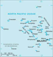 |
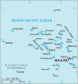
The Marshalls consist of 29 atolls and five isolated islands, which form two parallel groups--the "Ratak" (sunrise) chain and the "Ralik" (sunset) chain. The Marshalls share maritime boundaries
Maritime boundary
Maritime boundary is a conceptual means of division of the water surface of the planet into maritime areas that are defined through surrounding physical geography or by human geography. As such it usually includes areas of exclusive national rights over the mineral and biological resources,...
with Micronesia
Micronesia
Micronesia is a subregion of Oceania, comprising thousands of small islands in the western Pacific Ocean. It is distinct from Melanesia to the south, and Polynesia to the east. The Philippines lie to the west, and Indonesia to the southwest....
and Kiribati
Kiribati
Kiribati , officially the Republic of Kiribati, is an island nation located in the central tropical Pacific Ocean. The permanent population exceeds just over 100,000 , and is composed of 32 atolls and one raised coral island, dispersed over 3.5 million square kilometres, straddling the...
. Two-thirds of the nation's population lives in Majuro
Majuro
Majuro , is a large coral atoll of 64 islands in the Pacific Ocean, and forms a legislative district of the Ratak Chain of the Marshall Islands. The atoll itself has a land area of and encloses a lagoon of...
and Ebeye
Ebeye
Ebeye is the most populous island of Kwajalein Atoll in the Marshall Islands, as well as the center for Marshallese culture in the Ralik Chain of the archipelago. Settled on 80 acres of land, it has a population of more than 15,000. Over 50% of the population is estimated to be under the age of...
. The outer islands are sparsely populated due to lack of employment opportunities and economic development.
Location:
Oceania
Oceania
Oceania is a region centered on the islands of the tropical Pacific Ocean. Conceptions of what constitutes Oceania range from the coral atolls and volcanic islands of the South Pacific to the entire insular region between Asia and the Americas, including Australasia and the Malay Archipelago...
, group of atolls and reefs in the North Pacific Ocean, about one-half of the way from Hawaii
Hawaii
Hawaii is the newest of the 50 U.S. states , and is the only U.S. state made up entirely of islands. It is the northernmost island group in Polynesia, occupying most of an archipelago in the central Pacific Ocean, southwest of the continental United States, southeast of Japan, and northeast of...
to Papua New Guinea
Papua New Guinea
Papua New Guinea , officially the Independent State of Papua New Guinea, is a country in Oceania, occupying the eastern half of the island of New Guinea and numerous offshore islands...
Geographic coordinates:
9°00′N 168°00′E
Map references:
Oceania
Area:
total:
181.3 km²
land:
181.3 km²
water:
0 km²
note:
includes the atolls of Bikini
Bikini Atoll
Bikini Atoll is an atoll, listed as a World Heritage Site, in the Micronesian Islands of the Pacific Ocean, part of Republic of the Marshall Islands....
, Enewetak
Enewetak
Enewetak Atoll is a large coral atoll of 40 islands in the Pacific Ocean, and forms a legislative district of the Ralik Chain of the Marshall Islands. Its land area totals less than , surrounding a deep central lagoon, in circumference...
, and Kwajalein
Kwajalein
Kwajalein Atoll , is part of the Republic of the Marshall Islands . The southernmost and largest island in the atoll is named Kwajalein Island. English-speaking residents of the U.S...
Area - comparative:
about the size of Washington, DC
Land boundaries:
0 km
Coastline:
370.4 km
Maritime claims:
contiguous zone:
24 nm
exclusive economic zone:
200 nm
territorial sea:
12 nm
Maritime boundaries:
- MicronesiaMicronesiaMicronesia is a subregion of Oceania, comprising thousands of small islands in the western Pacific Ocean. It is distinct from Melanesia to the south, and Polynesia to the east. The Philippines lie to the west, and Indonesia to the southwest....
- KiribatiKiribatiKiribati , officially the Republic of Kiribati, is an island nation located in the central tropical Pacific Ocean. The permanent population exceeds just over 100,000 , and is composed of 32 atolls and one raised coral island, dispersed over 3.5 million square kilometres, straddling the...
Climate:
wet season from May to November; hot and humid; islands border typhoon belt
Terrain:
low coral limestone and sand islands
Elevation extremes:
lowest point:
Pacific Ocean 0 meters
highest point:
unnamed location on Likiep 10 meters / 33 feet above sea level
Natural resources:
phosphate deposits, marine products, deep seabed minerals
Land use:
arable land:
0%
permanent crops:
60%
permanent pastures:
0%
forests and woodland:
0%
other:
40%
Irrigated land:
NA km²
Natural hazards:
occasional typhoons
Environment - current issues:
inadequate supplies of potable water
Environment - international agreements:
party to:
Biodiversity, Climate Change, Desertification, Law of the Sea, Ozone Layer Protection, Ship Pollution
signed, but not ratified:
Climate Change-Kyoto Protocol
Geography - note:
two archipelagic island chains of 30 atolls and 1,152 islands; Bikini and Enewetak are former US nuclear test sites; Kwajalein, the famous World War II
World War II
World War II, or the Second World War , was a global conflict lasting from 1939 to 1945, involving most of the world's nations—including all of the great powers—eventually forming two opposing military alliances: the Allies and the Axis...
battleground, is now used as a US missile test range
Extreme points
This is a list of the extreme points of the Marshall IslandsMarshall Islands
The Republic of the Marshall Islands , , is a Micronesian nation of atolls and islands in the middle of the Pacific Ocean, just west of the International Date Line and just north of the Equator. As of July 2011 the population was 67,182...
, the points that are farther north, south, east or west than any other location.
- Northern-most point – Bokak AtollBokak AtollBokak Atoll or Taongi Atoll is an uninhabited coral atoll in the Ratak Chain of the Marshall Islands, located in the North Pacific Ocean at...
(Taongi), Ratak ChainRatak ChainThe Ratak Chain is a chain of islands within the island nation of the Marshall Islands. Ratak means "sunrise". It lies just to the east of the country's other main island chain, the Ralik Chain...
* - Eastern-most point – Knox AtollKnox AtollKnox Atoll is an unihabited coral atoll of 18 islands in the Pacific Ocean, and is the southernmost atoll of the Ratak Chain of the Marshall Islands. The total land area is only , but it encloses a largely sand-filled lagoon with an area of . The atoll measures in length and is wide...
, Ratak ChainRatak ChainThe Ratak Chain is a chain of islands within the island nation of the Marshall Islands. Ratak means "sunrise". It lies just to the east of the country's other main island chain, the Ralik Chain... - Southern-most point – Ebon AtollEbon AtollEbon Atoll is a coral atoll of 22 islands in the Pacific Ocean, and forms a legislative district of the Ralik Chain of the Marshall Islands. Its total land area is only , but it encloses a deep lagoon with an area of . A passage leads to the lagoon from the southwest edge of the atoll. The...
, Ralik ChainRalik ChainThe Ralik Chain is a chain of islands within the island nation of the Marshall Islands. Ralik means "sunset". It lies just to the west of the country's other island chain, the Ratak Chain... - Western-most point - Ujelang AtollUjelang AtollUjelang Atoll is a coral atoll of 30 islands in the Pacific Ocean, in the Ralik Chain of the Marshall Islands. Its total land area is only , but it encloses a lagoon of...
, Ralik ChainRalik ChainThe Ralik Chain is a chain of islands within the island nation of the Marshall Islands. Ralik means "sunset". It lies just to the west of the country's other island chain, the Ratak Chain...
- Note: the government of the Marshall Islands claims Wake IslandWake IslandWake Island is a coral atoll having a coastline of in the North Pacific Ocean, located about two-thirds of the way from Honolulu west to Guam east. It is an unorganized, unincorporated territory of the United States, administered by the Office of Insular Affairs, U.S. Department of the Interior...
, currently under US administration. If this is considered part of the Marshall Islands than Toki Point on Peale Island, Wake IslandWake IslandWake Island is a coral atoll having a coastline of in the North Pacific Ocean, located about two-thirds of the way from Honolulu west to Guam east. It is an unorganized, unincorporated territory of the United States, administered by the Office of Insular Affairs, U.S. Department of the Interior...
is the northern-most point of the Marshall Islands