
Geography of Martinique
Encyclopedia
Statistics
Location:Caribbean, island in the Caribbean Sea, north of Trinidad and Tobago
Trinidad and Tobago
Trinidad and Tobago officially the Republic of Trinidad and Tobago is an archipelagic state in the southern Caribbean, lying just off the coast of northeastern Venezuela and south of Grenada in the Lesser Antilles...
Geographic coordinates:
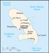
14°40′N 61°00′W
Map references:
Central America
Central America
Central America is the central geographic region of the Americas. It is the southernmost, isthmian portion of the North American continent, which connects with South America on the southeast. When considered part of the unified continental model, it is considered a subcontinent...
and the Caribbean
Caribbean
The Caribbean is a crescent-shaped group of islands more than 2,000 miles long separating the Gulf of Mexico and the Caribbean Sea, to the west and south, from the Atlantic Ocean, to the east and north...
Area:
total:
1,100 km²
land:
1,060 km²
water:
40 km²
Area - comparative:
slightly more than six times the size of Washington, D.C.
Washington, D.C.
Washington, D.C., formally the District of Columbia and commonly referred to as Washington, "the District", or simply D.C., is the capital of the United States. On July 16, 1790, the United States Congress approved the creation of a permanent national capital as permitted by the U.S. Constitution....
Land boundaries:
0 km
Coastline:
350 km
Maritime claims:
exclusive economic zone:
200 nmi (370.4 km; 230.2 mi)
territorial sea:
12 nmi (22.2 km; 13.8 mi)
Climate:
tropical; moderated by trade wind
Trade wind
The trade winds are the prevailing pattern of easterly surface winds found in the tropics, within the lower portion of the Earth's atmosphere, in the lower section of the troposphere near the Earth's equator...
s; rainy season (June to October); vulnerable to devastating cyclones (hurricanes) every eight years on average; average temperature 17.3 degrees Celsius; humid
Terrain:
mountainous with indented coastline; dormant volcano
Elevation extremes:
lowest point:
Caribbean Sea 0 m
highest point:
Montagne Pelee 1,397 m
Natural resources:
coastal scenery and beaches, cultivable land
Land use:
arable land:
8%
permanent crops:
8%
permanent pastures:
17%
forests and woodland:
44%
other:
23% (1993 est.)
Irrigated land:
40 km² (1993 est.)
Natural hazards:
hurricanes, flooding, and volcanic activity (an average of one major natural disaster every five years)
Environment - current issues:
NA
Population:429,510