
Geographic Center of the Contiguous United States
Encyclopedia
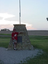
One of the locations claimed to be the Geographic Center of the Contiguous (or Conterminous) United States is pinpointed by a historical marker that is located within a small park near the town of Lebanon, Kansas
. It is located at the intersection of AA Road and K-191
, accessible by a turn-off from U.S. Route 281
approximately a mile north of the town.
This marker and the purported center should not be confused with the geographical center of the United States
, which is measured using all fifty states, not just the "lower 48."
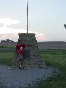
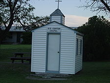 The marker supposedly indicates the actual point measured by a survey performed in 1918. In fact, the measured center is about a half to three-quarters of a mile away on a private farm. The farm's owner did not want tourists trudging through his field, so the marker was placed as close as possible. There is usually an American flag flying on the pole placed on top of the monument. Just to the south of the monument, yards away, is a covered picnic area and small four-pew chapel where a couple can take wedding vows.
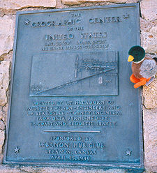
LAT. 39°50' LONG. 98°35'
NE 1/4 - SE 1/4 - S32 - T2S - R11W
Located by L.T. Hagadorn of Paulette & Wilson - Engineers and L.A. Beardslee - County Engineer. From data furnished by U.S. Coast and Geodetic Survey.
Sponsored by Lebanon Hub Club. Lebanon, Kansas. April 25, 1940.
Lebanon, Kansas
Lebanon is a city in Smith County, Kansas, United States, in the north central part of the state. As of the 2010 census, the city population was 218. In 1918, a scientific survey established that the geographic center of what was then the United States lies near the town and a monument was...
. It is located at the intersection of AA Road and K-191
K-191 (Kansas highway)
K-191 is a Kansas state highway originating at US-281 just north of Lebanon and ending a mile later at a monument marking the geographic center of the 48 contiguous states.-Route description:...
, accessible by a turn-off from U.S. Route 281
U.S. Route 281
U.S. Route 281 is a north–south United States highway. At 1,872 miles long it is the longest continuous three-digit U.S. Route....
approximately a mile north of the town.
This marker and the purported center should not be confused with the geographical center of the United States
Geographic center of the United States
Before 1959, the National Geodetic Survey placed the center of the United States at a point near the town of Lebanon, Kansas. When Alaska and Hawaii joined the union in 1959, the NGS designated Belle Fourche , South Dakota, the geographic center of the United States...
, which is measured using all fifty states, not just the "lower 48."
Marker near Lebanon, Kansas
Method of measurement
In 1918, the Coast and Geodetic Survey found this location by balancing on a point a cardboard cutout shaped like the U.S. Although this method was only accurate to within twenty miles, and the Geodetic Survey no longer endorses any location as the center of the U.S., the identification of Lebanon has stuck.The plaque's inscription
The GEOGRAPHIC CENTER of the UNITED STATESLAT. 39°50' LONG. 98°35'
NE 1/4 - SE 1/4 - S32 - T2S - R11W
Located by L.T. Hagadorn of Paulette & Wilson - Engineers and L.A. Beardslee - County Engineer. From data furnished by U.S. Coast and Geodetic Survey.
Sponsored by Lebanon Hub Club. Lebanon, Kansas. April 25, 1940.
See also
- Geographic center of the United StatesGeographic center of the United StatesBefore 1959, the National Geodetic Survey placed the center of the United States at a point near the town of Lebanon, Kansas. When Alaska and Hawaii joined the union in 1959, the NGS designated Belle Fourche , South Dakota, the geographic center of the United States...
- Geographic centers of the United StatesGeographic centers of the United StatesThis is a list of geographic centers of each U.S. state. Note that the geographical center of the entire U.S. is northeast of Belle Fourche in Butte County, South Dakota , while that of the contiguous 48 is near Lebanon in Smith County, Kansas...
- Mean center of U.S. populationMean center of U.S. populationThe mean center of U.S. population is determined by the United States Census Bureau from the results of each census. The Bureau defines it to be:...
- CentroidCentroidIn geometry, the centroid, geometric center, or barycenter of a plane figure or two-dimensional shape X is the intersection of all straight lines that divide X into two parts of equal moment about the line. Informally, it is the "average" of all points of X...
- Extreme points of the United StatesExtreme points of the United StatesThis is a list of the extreme points of the United States, the points that are farther north, south, east, or west than any other location in the country. Also included are extreme points in elevation, extreme distances, and other points of peculiar geographic interest.-Northernmost:*Point Barrow,...
External links
- The Center of the United States article about applying mathematical methods to geography
- Kansas Travel article
- Center for Land Use Interpretation article about the origins and accuracy of the marker
- Roadside America article
- USGS information
- Kansas Photo Tour
- New York Times