

GIS and aquatic science
Encyclopedia
Aquatic science
Aquatic Science is the multidisciplinary study of aquatic systems, encompassing both freshwater and marine systems. Scientific investigations within this field often examine the human impact on and interaction with aquatic systems and range in scale from the molecular level of contaminants to the...
and limnology
Limnology
Limnology , also called freshwater science, is the study of inland waters. It is often regarded as a division of ecology or environmental science. It covers the biological, chemical, physical, geological, and other attributes of all inland waters...
. Water by its very nature is dynamic. Features associated with water are thus ever-changing. To be able to keep up with these changes, technological advancements have given scientists methods to enhance all aspects of scientific investigation, from satellite tracking of wildlife to computer mapping of habitats. Agencies like the US Geological Survey, US Fish and Wildlife Service as well as other federal and state agencies are utilizing GIS to aid in their conservation efforts.
GIS is being used in multiple fields of aquatic science from limnology
Limnology
Limnology , also called freshwater science, is the study of inland waters. It is often regarded as a division of ecology or environmental science. It covers the biological, chemical, physical, geological, and other attributes of all inland waters...
, hydrology
Hydrology
Hydrology is the study of the movement, distribution, and quality of water on Earth and other planets, including the hydrologic cycle, water resources and environmental watershed sustainability...
, aquatic botany, stream ecology, oceanography
Oceanography
Oceanography , also called oceanology or marine science, is the branch of Earth science that studies the ocean...
and marine biology
Marine biology
Marine biology is the scientific study of organisms in the ocean or other marine or brackish bodies of water. Given that in biology many phyla, families and genera have some species that live in the sea and others that live on land, marine biology classifies species based on the environment rather...
. Applications include using satellite imagery to identify, monitor and mitigate habitat loss. Imagery can also show the condition of inaccessible areas. Scientists can track movements and develop a strategy to locate locations of concern. GIS can be used to track invasive species, endangered species, and population changes.
One of the advantages of the system is the availability for the information to be shared and updated at any time through the use of web-based data collection.
GIS and fish
Side-scan sonar
Side-scan sonar is a category of sonar system that is used to efficiently create an image of large areas of the sea floor...
biologists have been able to track fish species and create databases that can be incorporated into a GIS program to create a geographical representation. Using radio and hydroacoustic telemetry, biologists are able to locate fish and acquire relatable data for those sites, this data may include substrate
Substrate (marine biology)
Stream substrate is the material that rests at the bottom of a stream. There are several classification guides. One is:*Mud – silt and clay.*Sand – Particles between 0.06 and 2 mm in diameter.*Granule – Between 2 and 4 mm in diameter....
samples, temperature, and conductivity
Conductivity (electrolytic)
The conductivity of an electrolyte solution is a measure of its ability to conduct electricity. The SI unit of conductivity is siemens per meter ....
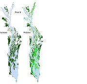
. Side-scan sonar allows biologists to map out a river bottom to gain a representation of possible habitats that are used. These two sets of data can be overlaid to delineate the distribution of fish and their habitats for fish. This method has been used in the study of the pallid sturgeon
Pallid sturgeon
The pallid sturgeon is an endangered species of ray-finned fish, endemic to the waters of the Missouri and lower Mississippi River basins of the United States...
.
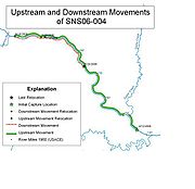
Over a period of time large amounts of data are collected and can be used to track patterns of migration, spawning locations and preferred habitat. Before, this data would be mapped and overlaid manually. Now this data can be entered into a GIS program and be layered, organized and analyzed in a way that was not possible to do in the past. Layering within a GIS program allows for the scientist to look at multiple species at once to find possible watersheds that are shared by these species, or to specifically choose one species for further examination.
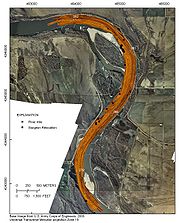
The US Geological Survey (USGS) in, cooperation with other agencies, were able to use GIS in helping map out habitat areas and movement patterns of pallid sturgeon
Pallid sturgeon
The pallid sturgeon is an endangered species of ray-finned fish, endemic to the waters of the Missouri and lower Mississippi River basins of the United States...
. At the Columbia Environmental Research Center their effort relies on a customized ArcPad and ArcGIS
ArcGIS
ArcGIS is a suite consisting of a group of geographic information system software products produced by Esri.ArcGIS is a system for working with maps and geographic information...
, both ESRI
ESRI
Esri is a software development and services company providing Geographic Information System software and geodatabase management applications. The headquarters of Esri is in Redlands, California....
(Environmental Systems Research Institute) applications, to record sturgeon movements to streamline data collection. A relational database was developed to manage tabular data for each individual sturgeon, including initial capture and reproductive physiology. Movement maps can be created for individual sturgeon. These maps help track the movements of each sturgeon through space and time. This allowed these researchers to prioritize and schedule field personnel efforts to track, map, and recapture sturgeon.
GIS and macrophytes
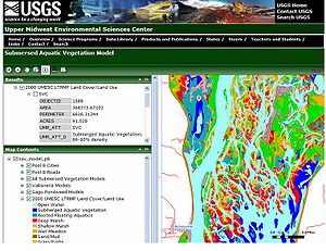
It is possible to predict the possible occurrences of aquatic vegetation. For example, the USGS has created a model for the American wild celery (Vallisneria americana) by developing a statistical model that calculates the probability of submersed aquatic vegetation. They established a web link to an Environmental Systems Research Institute (ESRI) ArcGIS Server website *Submersed Aquatic Vegetation Model to make their model predictions available online. These predictions for distribution of submerged aquatic vegetation can potentially have an effect on foraging birds by creating avoidance zones by humans. If it is known where these areas are, birds can be left alone to feed undisturbed. When there are years where the aquatic vegetation is predicted to be limited in these important wildlife habitats, managers can be alerted.
Invasive species
Invasive species
"Invasive species", or invasive exotics, is a nomenclature term and categorization phrase used for flora and fauna, and for specific restoration-preservation processes in native habitats, with several definitions....
have become a great conservation concern for resource managers. GIS allows managers to map out plant locations and abundances. These maps can then be used to determine the threat of these invasive plants and help the managers decide on management strategies. Surveys of these species can be conducted and then downloaded into a GIS system. Coupled with this, native species can be included to determine how these communities respond with each other. By using known data of preexisting invasive species GIS models could predict future outbreaks by comparing biological factors. The Connecticut Agricultural Experiment Station Invasive Aquatic Species Program (CAES IAPP) is using GIS to evaluate risk factors. GIS allows managers to georeference
Georeference
To georeference something means to define its existence in physical space. That is, establishing its location in terms of map projections or coordinate systems. The term is used both when establishing the relation between raster or vector images and coordinates, and when determining the spatial...
plant locations and abundance. This allows for managers to display invasive communities alongside native species for study and management.
External links
- Smithsonian National Zoological Park
- Missouri River InfoLINK
- Fisheries and Aquatics Bulletin
- Columbia Environmental Research Center
- Geographical Information Systems (GIS) for Fish Conservation
- GIS and Fish Population Dynamics
- ArcNews Online
- THE CONNECTICUT AGRICULTURAL EXPERIMENT STATION INVASIVE AQUATIC PLANT PROGRAM (CAES IAPP)
- Using GIS to Map Invasive Aquatic Plants in Connecticut Lakes
- Upper Midwest Environmental Sciences Center
- Smart River GIS for Improved Decision Making