

Fukue Island
Encyclopedia
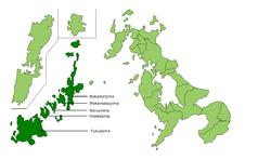
Goto Islands
The are Japanese islands in the East China Sea, off the western coast of Kyūshū. The islands are a part of Nagasaki Prefecture.- Geography :There are 140 islands in total, including five main islands:,,,, and....
in Japan
Japan
Japan is an island nation in East Asia. Located in the Pacific Ocean, it lies to the east of the Sea of Japan, China, North Korea, South Korea and Russia, stretching from the Sea of Okhotsk in the north to the East China Sea and Taiwan in the south...
. The island is part of the city of Gotō
Goto, Nagasaki
is a city in Nagasaki Prefecture, Japan. It comprises the south-west half of the Gotō Islands in the East China Sea, some 100 kilometers from Nagasaki. The city consists of 11 inhabited and 52 uninhabited islands...
in the Nagasaki Prefecture
Nagasaki Prefecture
is a prefecture of Japan located on the island of Kyūshū. The capital is the city of Nagasaki.- History :Nagasaki Prefecture was created by merging of the western half of the former province of Hizen with the island provinces of Tsushima and Iki...
. The Gotō-Fukue Airport
Goto-Fukue Airport
, is a third class airport located southwest of Gotō, Nagasaki Prefecture, off the western coast of Kyūshū, Japan. The airport also serves the city of Fukue. It is also known as .-External links:*...
is located on this island.
Climate
Fukue has a generally warm and very wet climate (KöppenKöppen climate classification
The Köppen climate classification is one of the most widely used climate classification systems. It was first published by Crimea German climatologist Wladimir Köppen in 1884, with several later modifications by Köppen himself, notably in 1918 and 1936...
Cfa) with hot and oppressively humid summers and cool, wet winters with practically no snowfall owing to the island’s southerly latitude. Despite this, during the winter months cold water transported south from the Sea of Okhotsk
Sea of Okhotsk
The Sea of Okhotsk is a marginal sea of the western Pacific Ocean, lying between the Kamchatka Peninsula on the east, the Kuril Islands on the southeast, the island of Hokkaidō to the far south, the island of Sakhalin along the west, and a long stretch of eastern Siberian coast along the west and...
by the eastern side of the Siberian High
Siberian High
The Siberian High is a massive collection of cold or very cold dry air that accumulates on the Eurasian terrain for much of the year. It reaches its greatest size and strength in the winter, when the air temperature near the center of the high-pressure cell or anticyclone is often lower than...
makes for very gloomy weather with scarcely any more sunshine than the “San‘in” coast from Hagi
Hagi, Yamaguchi
is a city located in Yamaguchi, Japan and was incorporated as a city on July 1, 1932. Formerly part of Abu District.On March 6, 2005, the former city of Hagi merged with the towns of Susa and Tamagawa, and the villages of Asahi, Fukue, Kawakami and Mutsumi to form the new city of Hagi.Iwami Airport...
to Wakkanai
Wakkanai, Hokkaido
is a city located in Sōya, Hokkaidō. It is the capital of Sōya Subprefecture and the northernmost city in Japan. It contains Japan's northernmost point, Cape Soya, from which the Russian island of Sakhalin can be seen....
. Like the rest of Kyūshū, Fukue and the other Gotō Islands are prone to typhoons during summer and autumn which can give daily rainfalls as high as 432.5 millimetres (17 in) on 10 September 2005 and 433.5 millimetres (17.1 in) on 7 July of 1987. The wettest month on record was July 1987 with 872 millimetres (34 in) and the driest was November 1971 with 3.5 millimetre (0.137795275590551 in).