

Friesland Ridge
Encyclopedia
South Shetland Islands
The South Shetland Islands are a group of Antarctic islands, lying about north of the Antarctic Peninsula, with a total area of . By the Antarctic Treaty of 1959, the Islands' sovereignty is neither recognized nor disputed by the signatories and they are free for use by any signatory for...
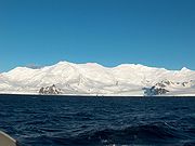
, part of the Tangra Mountains
Tangra Mountains
Tangra Mountains form the principal mountain range of Livingston Island in the South Shetland Islands, Antarctica...
. The summit, Mount Friesland
Mount Friesland
Mount Friesland is the summit of Tangra Mountains on Livingston Island, in the South Shetland Islands, Antarctica. The peak is rising to 1700 m sharp, and is heavily glaciated and crevassed. Situated 12.5 km northeast of Barnard Point, 9.7 km east-southeast of St...
, which rises to 1700 metres (5,577.4 ft), is the northwesternmost of the ridge’s six main peaks. The summit elevation was estimated at 1684 metres (5,524.9 ft) by a 1995/96 Bulgarian survey; the present figure was produced by a 2003 Australian GPS survey, and confirmed by the Bulgarian survey Tangra 2004/05
Tangra 2004/05
The Tangra 2004/05 Expedition was commissioned by the Antarctic Place-names Commission at the Ministry of Foreign Affairs of Bulgaria, managed by the Manfred Wörner Foundation, and supported by the Bulgarian Antarctic Institute, the Institute of Mathematics and Informatics at the Bulgarian Academy...
.
First ascent of the summit Mount Friesland by the Catalans Francesc Sàbat and Jorge Enrique from Juan Carlos I Base
Juan Carlos I Base
Juan Carlos I Antarctic Base, named after the king of Spain, Juan Carlos I, is a seasonal scientific station operated by Spain, opened in January 1988...
on 30 December 1991.
The feature takes its name from Mount Friesland
Mount Friesland
Mount Friesland is the summit of Tangra Mountains on Livingston Island, in the South Shetland Islands, Antarctica. The peak is rising to 1700 m sharp, and is heavily glaciated and crevassed. Situated 12.5 km northeast of Barnard Point, 9.7 km east-southeast of St...
.
Location
The midpoint of the ridge is located at 62°42′15"S 60°13′30"W (UK Directorate of Overseas Surveys mapping in 1968, partial mapping by the Spanish Servicio Geográfico del Ejército in 1991, and Bulgarian mapping in 2005 from topographic surveys in 1995/96 and 2004/05).Maps
- L.L. Ivanov et al. Antarctica: Livingston Island and Greenwich Island, South Shetland Islands. Scale 1:100000 topographic map. Sofia: Antarctic Place-names Commission of Bulgaria, 2005.
- L.L. Ivanov. Antarctica: Livingston Island and Greenwich, Robert, Snow and Smith Islands. Scale 1:120000 topographic map. Troyan: Manfred Wörner Foundation, 2009. ISBN 978-954-92032-6-4