

Fraser, Colorado
Encyclopedia
Fraser is a Statutory Town in Grand County
, Colorado
, United States. The population was 910 at the 2000 census
. The town is in Middle Park
in the valley of the Fraser River
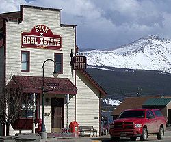
along U.S. Highway 40. Its location northwest of Winter Park
, the location of several popular ski resorts, has provided growth in recent years with new condominium
and other real estate
developments.
This town is at an elevation of 8550 feet (2601 m) and was established in 1904 in anticipation of the arrival of the Moffat Railroad. It was laid out on the western high bank of the Fraser River by George Eastom and originally named for him, but this name did not stick, for the town soon resorted to the name given the original rural post office: Fraser. The origin of the name Fraser cannot be confirmed. Rueben Frazier, an early settler in the area, was well known by most of the locals and it wasn't long before people started calling the town Frazier. When the US Postal Authority granted a post office they wanted an easier spelling so took the name of the nearby Fraser River. It was the center of the timber industry until the Forest Service headquarters was moved to Hot Sulphur Springs in 1915, and the Ranger Station to Idlewild. The town was incorporated in 1953.
Fraser, with an annual mean temperature of 32.5 °F (or 34.8 °F (1.6 °C) based on another station in town) is the coldest incorporated town in the lower 48 states. It also has the shortest growing season with an average of only 4 to 7 days (depending on which weather station data is used) and can and does get frost year-round. Both Fraser and International Falls, Minnesota
have claimed the title "Icebox of the Nation," which has caused conflict between the two towns over the years.
, the national passenger rail system, provides service to Fraser and nearby Winter Park
, operating its California Zephyr
daily in each direction between Chicago
and Emeryville, California
, across the bay from San Francisco.
 Fraser is located at 39°56′39"N 105°48′48"W (39.944158, -105.813355).
According to the United States Census Bureau
, the town has a total area of 1.9 square miles (4.9 km²), of which, 1.9 square miles (4.9 km²) of it is land and 0.04 square mile (0.1035995244 km²) of it (1.07%) is water.
of 2000, there were 910 people, 410 households, and 191 families residing in the town. The population density
was 491.1 people per square mile (189.9/km²). There were 622 housing units at an average density of 335.7 per square mile (129.8/km²). The racial makeup of the town was 94.51% White, 0.88% African American, 0.88% Native American, 0.88% Asian, 0.22% Pacific Islander, 1.10% from other races
, and 1.54% from two or more races. Hispanic or Latino of any race were 3.30% of the population.
There were 410 households out of which 25.1% had children under the age of 18 living with them, 33.2% were married couples living together, 9.0% had a female householder with no husband present, and 53.2% were non-families. 27.6% of all households were made up of individuals and 3.2% had someone living alone who was 65 years of age or older. The average household size was 2.21 and the average family size was 2.71.
In the town the population was spread out with 17.9% under the age of 18, 14.2% from 18 to 24, 46.2% from 25 to 44, 18.0% from 45 to 64, and 3.7% who were 65 years of age or older. The median age was 31 years. For every 100 females there were 129.8 males. For every 100 females age 18 and over, there were 130.6 males.
The median income for a household in the town was $38,173, and the median income for a family was $39,643. Males had a median income of $29,583 versus $26,346 for females. The per capita income
for the town was $20,628. About 11.1% of families and 8.8% of the population were below the poverty line, including 9.8% of those under age 18 and none of those age 65 or over.
Grand County, Colorado
Grand County is the 21st largest of the 64 counties of the State of Colorado of the United States. The county population was 12,442 at U.S. Census 2000...
, Colorado
Colorado
Colorado is a U.S. state that encompasses much of the Rocky Mountains as well as the northeastern portion of the Colorado Plateau and the western edge of the Great Plains...
, United States. The population was 910 at the 2000 census
United States Census, 2000
The Twenty-second United States Census, known as Census 2000 and conducted by the Census Bureau, determined the resident population of the United States on April 1, 2000, to be 281,421,906, an increase of 13.2% over the 248,709,873 persons enumerated during the 1990 Census...
. The town is in Middle Park
Middle Park (Colorado basin)
Middle Park is a high basin in the Rocky Mountains of north-central Colorado in the United States. It is located in Grand County, on the southwest slope of Rocky Mountain National Park, approximately 50 miles west of Boulder.-Description:The basin surrounds the headwaters of the Colorado River...
in the valley of the Fraser River
Fraser River (Colorado)
The Fraser River is a tributary of the Colorado River, approximately long, in north central Colorado in the United States. It drains large portion of the Middle Park basin in Grand County in the Rocky Mountains west of Boulder and southwest of Rocky Mountain National Park. It rises at the...
along U.S. Highway 40. Its location northwest of Winter Park
Winter Park, Colorado
Winter Park is a Home Rule Municipality in Grand County, Colorado, United States. The town population was 662 at the 2000 census, although tourists and seasonal workers significantly increase the population....
, the location of several popular ski resorts, has provided growth in recent years with new condominium
Condominium
A condominium, or condo, is the form of housing tenure and other real property where a specified part of a piece of real estate is individually owned while use of and access to common facilities in the piece such as hallways, heating system, elevators, exterior areas is executed under legal rights...
and other real estate
Real estate
In general use, esp. North American, 'real estate' is taken to mean "Property consisting of land and the buildings on it, along with its natural resources such as crops, minerals, or water; immovable property of this nature; an interest vested in this; an item of real property; buildings or...
developments.
This town is at an elevation of 8550 feet (2601 m) and was established in 1904 in anticipation of the arrival of the Moffat Railroad. It was laid out on the western high bank of the Fraser River by George Eastom and originally named for him, but this name did not stick, for the town soon resorted to the name given the original rural post office: Fraser. The origin of the name Fraser cannot be confirmed. Rueben Frazier, an early settler in the area, was well known by most of the locals and it wasn't long before people started calling the town Frazier. When the US Postal Authority granted a post office they wanted an easier spelling so took the name of the nearby Fraser River. It was the center of the timber industry until the Forest Service headquarters was moved to Hot Sulphur Springs in 1915, and the Ranger Station to Idlewild. The town was incorporated in 1953.
Fraser, with an annual mean temperature of 32.5 °F (or 34.8 °F (1.6 °C) based on another station in town) is the coldest incorporated town in the lower 48 states. It also has the shortest growing season with an average of only 4 to 7 days (depending on which weather station data is used) and can and does get frost year-round. Both Fraser and International Falls, Minnesota
International Falls, Minnesota
International Falls is a city in and the county seat of Koochiching County, Minnesota, United States. The population was 6,424 at the 2010 census....
have claimed the title "Icebox of the Nation," which has caused conflict between the two towns over the years.
Transportation
AmtrakAmtrak
The National Railroad Passenger Corporation, doing business as Amtrak , is a government-owned corporation that was organized on May 1, 1971, to provide intercity passenger train service in the United States. "Amtrak" is a portmanteau of the words "America" and "track". It is headquartered at Union...
, the national passenger rail system, provides service to Fraser and nearby Winter Park
Winter Park, Colorado
Winter Park is a Home Rule Municipality in Grand County, Colorado, United States. The town population was 662 at the 2000 census, although tourists and seasonal workers significantly increase the population....
, operating its California Zephyr
California Zephyr
The California Zephyr is a long passenger train route operated by Amtrak in the midwestern and western United States.It runs from Chicago, Illinois, in the east to Emeryville, California, in the west, passing through the states of Illinois, Iowa, Nebraska, Colorado, Utah, Nevada, and California...
daily in each direction between Chicago
Union Station (Chicago)
Union Station is a major train station that opened in 1925 in Chicago, replacing an earlier 1881 station. It is now the only intercity rail terminal in Chicago, as well as being the city's primary terminal for commuter trains. The station stands on the west side of the Chicago River between Adams...
and Emeryville, California
Emeryville, California
Emeryville is a small city located in Alameda County, California, in the United States. It is located in a corridor between the cities of Berkeley and Oakland, extending to the shore of San Francisco Bay. Its proximity to San Francisco, the Bay Bridge, the University of California, Berkeley, and...
, across the bay from San Francisco.
Geography
According to the United States Census Bureau
United States Census Bureau
The United States Census Bureau is the government agency that is responsible for the United States Census. It also gathers other national demographic and economic data...
, the town has a total area of 1.9 square miles (4.9 km²), of which, 1.9 square miles (4.9 km²) of it is land and 0.04 square mile (0.1035995244 km²) of it (1.07%) is water.
Demographics
As of the censusCensus
A census is the procedure of systematically acquiring and recording information about the members of a given population. It is a regularly occurring and official count of a particular population. The term is used mostly in connection with national population and housing censuses; other common...
of 2000, there were 910 people, 410 households, and 191 families residing in the town. The population density
Population density
Population density is a measurement of population per unit area or unit volume. It is frequently applied to living organisms, and particularly to humans...
was 491.1 people per square mile (189.9/km²). There were 622 housing units at an average density of 335.7 per square mile (129.8/km²). The racial makeup of the town was 94.51% White, 0.88% African American, 0.88% Native American, 0.88% Asian, 0.22% Pacific Islander, 1.10% from other races
Race (United States Census)
Race and ethnicity in the United States Census, as defined by the Federal Office of Management and Budget and the United States Census Bureau, are self-identification data items in which residents choose the race or races with which they most closely identify, and indicate whether or not they are...
, and 1.54% from two or more races. Hispanic or Latino of any race were 3.30% of the population.
There were 410 households out of which 25.1% had children under the age of 18 living with them, 33.2% were married couples living together, 9.0% had a female householder with no husband present, and 53.2% were non-families. 27.6% of all households were made up of individuals and 3.2% had someone living alone who was 65 years of age or older. The average household size was 2.21 and the average family size was 2.71.
In the town the population was spread out with 17.9% under the age of 18, 14.2% from 18 to 24, 46.2% from 25 to 44, 18.0% from 45 to 64, and 3.7% who were 65 years of age or older. The median age was 31 years. For every 100 females there were 129.8 males. For every 100 females age 18 and over, there were 130.6 males.
The median income for a household in the town was $38,173, and the median income for a family was $39,643. Males had a median income of $29,583 versus $26,346 for females. The per capita income
Per capita income
Per capita income or income per person is a measure of mean income within an economic aggregate, such as a country or city. It is calculated by taking a measure of all sources of income in the aggregate and dividing it by the total population...
for the town was $20,628. About 11.1% of families and 8.8% of the population were below the poverty line, including 9.8% of those under age 18 and none of those age 65 or over.
Climate
See also
- State of Colorado
- Colorado cities and towns
- Colorado municipalitiesColorado municipalitiesThe U.S. state of Colorado currently has 271 active incorporated municipalities, including 196 towns, 73 cities, and two consolidated city and county governments.-Municipal government:...
- Colorado municipalities
- Colorado countiesColorado countiesThe U.S state of Colorado is divided into 64 counties. Counties are important units of government in Colorado since the state has no secondary civil subdivisions, such as townships...
- Grand County, ColoradoGrand County, ColoradoGrand County is the 21st largest of the 64 counties of the State of Colorado of the United States. The county population was 12,442 at U.S. Census 2000...
- Grand County, Colorado
- Colorado cities and towns
- United States Forest ServiceUnited States Forest ServiceThe United States Forest Service is an agency of the United States Department of Agriculture that administers the nation's 155 national forests and 20 national grasslands, which encompass...
- Arapaho National ForestArapaho National ForestArapaho National Forest is a National Forest located in north-central Colorado, United States. The facility is managed jointly with the Roosevelt National Forest and the Pawnee National Grassland from the United States Forest Service office in Fort Collins, Colorado...
- Arapaho National Forest