

Frankston Freeway
Encyclopedia
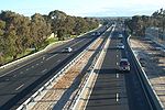
 Frankston Freeway is a very short stretch of Melbourne
Melbourne
Melbourne is the capital and most populous city in the state of Victoria, and the second most populous city in Australia. The Melbourne City Centre is the hub of the greater metropolitan area and the Census statistical division—of which "Melbourne" is the common name. As of June 2009, the greater...
freeway that was designed to upgrade Wells Road to freeway standard in the 1970s and provides a link from suburban Melbourne to Frankston. The freeway is commonly congested in holiday months due to the omission of the Frankston Bypass, but that bypass is now being built as part of the Peninsula Link project to be completed in 2013.
History
 an undivided highway between Frankston-Cranbourne Road and Seaford Road. It then continued on to Mordialloc
Mordialloc, Victoria
Mordialloc is a suburb in Melbourne, Victoria, Australia, 24 km south-east from Melbourne's central business district. Its Local Government Area is the City of Kingston...
as Wells Road. The Wells Road Bypass was upgraded to freeway standard in the early 1970s and by around 1980 the rest of the freeway was constructed to Springvale Road alongside the existing Wells Road.
With the route numbering conversion of the freeway, it was initially going to be changed to after the completion of EastLink
EastLink, Melbourne
EastLink is a A$2.5 billion tolled freeway linking a large area through the eastern and south-eastern suburbs of Melbourne, Australia. It is a part of Melbourne's Metropolitan Ring Road project....
in 2008, although plans fell through and the route was retained as
). However with the construction and completion of the Peninsula Link in the coming years, it will be replaced with  , with the Peninsula Link and Mornington Peninsula Freeway signed as .
Route
The Frankston Freeway was designed to accommodate Mornington Peninsula Freeway from the northern section, and it has had a missing Frankston Bypass for decades (VicroadsVicRoads
VicRoads or the Roads Corporation of Victoria is a statutory corporation which is the state road and traffic authority in the state of Victoria, Australia. It is responsible for maintenance and construction of the state arterial road network, as well as driver licensing and vehicle registration. ...
having decided that traffic on the route was not heavy enough to merit a Frankston Bypass, the middle section of the freeway), and at this stage the Frankston Freeway serves as the missing link between the two Mornington Peninsula Freeways.
The Frankston Freeway begins in Carrum Downs south until Cranbourne Road, as the incomplete section of the actual Mornington Peninsula Freeway, which bypasses Frankston, swings off to the south east. The newly-completed Eastlink
EastLink, Melbourne
EastLink is a A$2.5 billion tolled freeway linking a large area through the eastern and south-eastern suburbs of Melbourne, Australia. It is a part of Melbourne's Metropolitan Ring Road project....
toll road is continuous with the Carrum Downs end of the Frankston Freeway, providing a freeway standard road north through the Eastern suburbs of Melbourne to the Eastern end of the Eastern Freeway, and beyond.
The freeway is generally parallel to Nepean Highway
Nepean Highway
Nepean Highway runs south from the centre of Melbourne in Victoria, Australia to Portsea, along the eastern shore of Port Phillip. It is the primary road route to central Melbourne from Melbourne's southern suburbs.- History :...
along the route including the Mornington Peninsula Freeway
Mornington Peninsula Freeway
Mornington Peninsula Freeway is an incomplete freeway in Melbourne, Victoria, Australia, that provides a link from outer suburban Melbourne to the Mornington Peninsula.- History :...
and Moorooduc Highway
Moorooduc Highway
The Moorooduc Highway is a 19 km highway which runs from Frankston to Mount Martha. It is a dual carriageway with two or three lanes each way and, together with the Mornington Peninsula Freeway, is a main arterial road from Melbourne to the Mornington Peninsula.- History :It originally started...
.
Exits and Interchanges
| Frankston Freeway |
|||
| Northbound exits | Distance to Melbourne (km) |
Distance to Frankston (km) |
Southbound exits |
| End Frankston Freeway continues as EastLink EastLink, Melbourne EastLink is a A$2.5 billion tolled freeway linking a large area through the eastern and south-eastern suburbs of Melbourne, Australia. It is a part of Melbourne's Metropolitan Ring Road project.... to Melbourne Melbourne Melbourne is the capital and most populous city in the state of Victoria, and the second most populous city in Australia. The Melbourne City Centre is the hub of the greater metropolitan area and the Census statistical division—of which "Melbourne" is the common name. As of June 2009, the greater...  |
47 | 5 | Start Frankston Freeway from EastLink EastLink, Melbourne EastLink is a A$2.5 billion tolled freeway linking a large area through the eastern and south-eastern suburbs of Melbourne, Australia. It is a part of Melbourne's Metropolitan Ring Road project.... and Mornington Peninsula Freeway Mornington Peninsula Freeway Mornington Peninsula Freeway is an incomplete freeway in Melbourne, Victoria, Australia, that provides a link from outer suburban Melbourne to the Mornington Peninsula.- History :... |
| Springvale Springvale, Victoria Springvale is a suburb in Melbourne, Victoria, Australia, approximately 20 km south-east from Melbourne's central business district. Its Local Government Area is the City of Greater Dandenong... , Mordialloc Mordialloc, Victoria Mordialloc is a suburb in Melbourne, Victoria, Australia, 24 km south-east from Melbourne's central business district. Its Local Government Area is the City of Kingston... Mornington Peninsula Freeway Mornington Peninsula Freeway Mornington Peninsula Freeway is an incomplete freeway in Melbourne, Victoria, Australia, that provides a link from outer suburban Melbourne to the Mornington Peninsula.- History :... |
|||
| Seaford Seaford, Victoria Seaford is a suburb in Melbourne, Victoria, Australia, 36 km south-east from Melbourne's central business district. Its Local Government Area is the City of Frankston... , Skye Skye, Victoria Skye is a suburb in Melbourne, Victoria, Australia, 38 km south-east from Melbourne's central business district. Its Local Government Area is the City of Frankston. At the 2006 Census, Skye had a population of 6898.-History:... Seaford Road |
49 | 3 | Skye Skye, Victoria Skye is a suburb in Melbourne, Victoria, Australia, 38 km south-east from Melbourne's central business district. Its Local Government Area is the City of Frankston. At the 2006 Census, Skye had a population of 6898.-History:... , Seaford Seaford, Victoria Seaford is a suburb in Melbourne, Victoria, Australia, 36 km south-east from Melbourne's central business district. Its Local Government Area is the City of Frankston... Seaford Road |
| Frankston Frankston, Victoria Frankston is a suburb within the Greater Melbourne metropolitan area in Victoria, Australia. It is located 40 km southeast of the state capital Melbourne at the southernmost edge of Greater Melbourne, near the beginnings of the Mornington Peninsula... , Dandenong Dandenong, Victoria Dandenong is a suburb and major urban centre in metropolitan Melbourne, Victoria, Australia, 30 km south-east from Melbourne's central business district. Situated on Dandenong Creek and mostly flat land at the foothills of Mount Dandenong, it is the main administrative centre for the City of... Dandenong Valley Highway Dandenong Valley Highway The Dandenong Valley Highway stretches almost 30 kilometres from Wantirna South in Melbourne's eastern suburbs to Frankston in the south. For its entire length, its main name is not actually Dandenong Valley Highway, and very few locals use it...  |
51 | 1 | Dandenong Dandenong, Victoria Dandenong is a suburb and major urban centre in metropolitan Melbourne, Victoria, Australia, 30 km south-east from Melbourne's central business district. Situated on Dandenong Creek and mostly flat land at the foothills of Mount Dandenong, it is the main administrative centre for the City of... , Frankston Frankston, Victoria Frankston is a suburb within the Greater Melbourne metropolitan area in Victoria, Australia. It is located 40 km southeast of the state capital Melbourne at the southernmost edge of Greater Melbourne, near the beginnings of the Mornington Peninsula... Dandenong Valley Highway Dandenong Valley Highway The Dandenong Valley Highway stretches almost 30 kilometres from Wantirna South in Melbourne's eastern suburbs to Frankston in the south. For its entire length, its main name is not actually Dandenong Valley Highway, and very few locals use it... |
| Northbound exits | Distance to Melbourne (km) |
Distance to Portsea (km) |
Southbound exits |
| Beach Street | 54 | 56 | no exit |
| Start Frankston Freeway |
End Frankston Freeway |
||
.svg.png)  Traffic Lights (clockwise from freeway) Traffic Lights (clockwise from freeway) Cranbourne Road  to Cranbourne to CranbourneCranbourne, Victoria Cranbourne is a suburb in Melbourne, Victoria, Australia, 43 km south-east from Melbourne's central business district. Its Local Government Area is the City of Casey. At the 2006 Census, Cranbourne had a population of 14,750.... McMahons Road Moorooduc Highway The Moorooduc Highway is a 19 km highway which runs from Frankston to Mount Martha. It is a dual carriageway with two or three lanes each way and, together with the Mornington Peninsula Freeway, is a main arterial road from Melbourne to the Mornington Peninsula.- History :It originally started... to PortseaPortsea, Victoria Portsea is a resort town located across Port Phillip from Melbourne, Victoria, Australia. Its Local Government Area is the Shire of Mornington Peninsula.... and Flinders Flinders, Victoria Flinders is a historic town south of Melbourne, Victoria, Australia, located on the Mornington Peninsula at the point where Western Port meets Bass Strait. Its Local Government Area is the Shire of Mornington Peninsula... Cranbourne Road to Frankston City CentreFrankston, Victoria Frankston is a suburb within the Greater Melbourne metropolitan area in Victoria, Australia. It is located 40 km southeast of the state capital Melbourne at the southernmost edge of Greater Melbourne, near the beginnings of the Mornington Peninsula... |
|||
See also
- Freeways in AustraliaFreeways in AustraliaThis is a list of freeways and motorways in Australia, sorted by states and territories and their corresponding routes. This list includes toll roads such as the CityLink freeway system in Melbourne. This list has over 70 entries...
- Freeways in Melbourne
- Road transport in Victoria