

Frank Swannell
Encyclopedia
British Columbia
British Columbia is the westernmost of Canada's provinces and is known for its natural beauty, as reflected in its Latin motto, Splendor sine occasu . Its name was chosen by Queen Victoria in 1858...
's most famous surveyors
Surveying
See Also: Public Land Survey SystemSurveying or land surveying is the technique, profession, and science of accurately determining the terrestrial or three-dimensional position of points and the distances and angles between them...
.
He came to British Columbia during the era of the Klondike Gold Rush
Klondike Gold Rush
The Klondike Gold Rush, also called the Yukon Gold Rush, the Alaska Gold Rush and the Last Great Gold Rush, was an attempt by an estimated 100,000 people to travel to the Klondike region the Yukon in north-western Canada between 1897 and 1899 in the hope of successfully prospecting for gold...
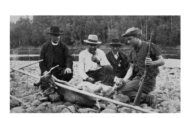
and became a surveyor's assistant. Then, from 1908, he was a professional surveyor and surveyed many regions of British Columbia. He kept a journal of his work and collected over 5000 unique pictures of the era, which were donated to BC Archives for the benefit of future researchers. The photographs span a period of more than 40 years and cover many areas of the province. Their subjects include stagecoaches, sternwheelers, old forts and remote villages, mountains and rivers, pioneer settlers, miners and First Nations
First Nations
First Nations is a term that collectively refers to various Aboriginal peoples in Canada who are neither Inuit nor Métis. There are currently over 630 recognised First Nations governments or bands spread across Canada, roughly half of which are in the provinces of Ontario and British Columbia. The...
people. Swannell's pictures are a priceless contribution to the history of British Columbia.
Early years
Swannell graduated from high school in Toronto and then attended a two year program in mining engineering at the University of TorontoUniversity of Toronto
The University of Toronto is a public research university in Toronto, Ontario, Canada, situated on the grounds that surround Queen's Park. It was founded by royal charter in 1827 as King's College, the first institution of higher learning in Upper Canada...
from 1897-1899. In the summer of 1898, he worked for a surveying firm in New Denver, British Columbia
New Denver, British Columbia
New Denver is a village in southeastern British Columbia, Canada, along the shore of Slocan Lake. New Denver was founded as a mining town in 1892, and briefly known as Eldorado City before being renamed after Denver, Colorado. It was incorporated as a village in 1929 and currently has approximately...
.
After he graduated, he intended to travel to the Yukon
Yukon
Yukon is the westernmost and smallest of Canada's three federal territories. It was named after the Yukon River. The word Yukon means "Great River" in Gwich’in....
to participate in the Klondike Gold Rush, but instead obtained work with the Victoria surveyors, Gore and McGregor, receiving his Provincial Land Surveying licence and Dominion Land Surveying licence in 1903 and 1904 respectively. In 1908, Swannell left the firm and struck out on his own and sooned gained a reputation for being among the best in the business.
1908-1914
Grand Trunk Pacific Railway
The Grand Trunk Pacific Railway was a historical Canadian railway.A wholly owned subsidiary of the Grand Trunk Railway , the GTPR was constructed by GTR using loans provided by the Government of Canada. The company was formed in 1903 with a mandate to build west from Winnipeg, Manitoba to the...
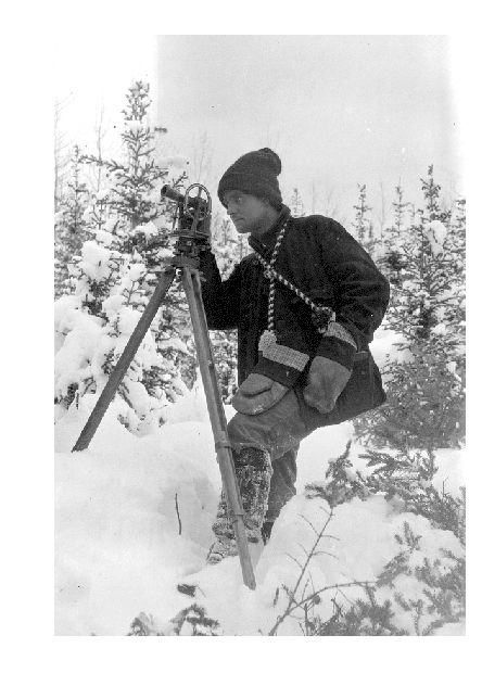
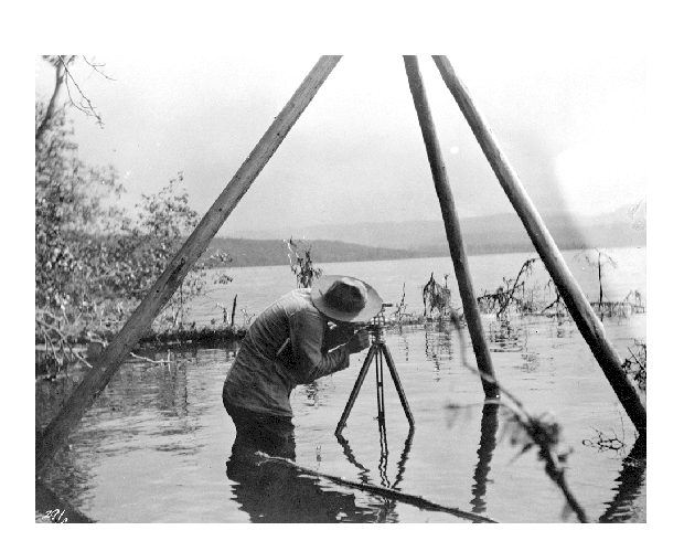
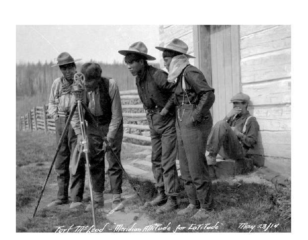
caused a great deal of interest in Central and Northern British Columbia, and settlers were arriving looking for agricultural land, which needed to be surveyed before it could be sold or pre-empted. The equipment the surveyors used would be considered simple by today's standards, but it was remarkably accurate: a transit
Theodolite
A theodolite is a precision instrument for measuring angles in the horizontal and vertical planes. Theodolites are mainly used for surveying applications, and have been adapted for specialized purposes in fields like metrology and rocket launch technology...
and a 66 foot length of chain (80 lengths to a mile). The pioneer surveyors did more than survey land, they also recorded the topography
Topography
Topography is the study of Earth's surface shape and features or those ofplanets, moons, and asteroids...
, soil conditions and potential uses of the land, information that was a necessity for the government and land-seekers alike.
Swannell and his crew worked in the summers and he kept his winter home in Victoria.
When spring came, they would travel from Vancouver on the Canadian Pacific Railway
Canadian Pacific Railway
The Canadian Pacific Railway , formerly also known as CP Rail between 1968 and 1996, is a historic Canadian Class I railway founded in 1881 and now operated by Canadian Pacific Railway Limited, which began operations as legal owner in a corporate restructuring in 2001...
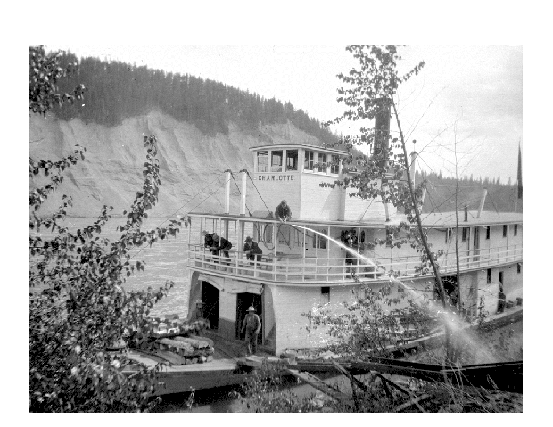
to Ashcroft and take a stagecoach to Soda Creek where the sternwheeler Charlotte
Charlotte (sternwheeler)
The Charlotte sternwheeler was built in 1896 by Alexander Watson for the Northern British Columbia Navigation Company. The partners of the NBCNC were Stephen Tingley, Senator James Reid and John Irving...
would take them to Quesnel
Quesnel, British Columbia
-Demographics:Quesnel had a population of 9,326 people in 2006, which was a decrease of 7.1% from the 2001 census count. The median household income in 2005 for Quesnel was $54,044, which is slightly above the British Columbia provincial average of $52,709....
. From Quesnel it was ten day hike along the Yukon Telegraph Trail to the Nechako Valley.
Aside from surveying, Swannell also had to worry about keeping food supplies on hand for his crew, a problem which was quite often nearly insurmountable as there were few farms in the region and goods often took three weeks or longer to arrive from Hudson's Bay Company
Hudson's Bay Company
The Hudson's Bay Company , abbreviated HBC, or "The Bay" is the oldest commercial corporation in North America and one of the oldest in the world. A fur trading business for much of its existence, today Hudson's Bay Company owns and operates retail stores throughout Canada...
stores on pack trains or by canoe.
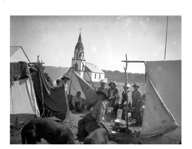
During that first summer, Swannell and his crew surveyed the area around Fort Fraser, Fraser Lake and Stoney Creek.
Lillooet, British Columbia
Lillooet is a community on the Fraser River in western Canada, about up the British Columbia Railway line from Vancouver. Situated at an intersection of deep gorges in the lee of the Coast Mountains, it has a dry climate- of precipitation is recorded annually at the town's weather station,...
and Pemberton
Pemberton, British Columbia
Pemberton is a village north of Whistler in the Pemberton Valley of British Columbia in Canada, with a population of 2,192. Until the 1960s the village could be accessed only by train but that changed when Highway 99 was built through Whistler and Pemberton.-Climate:The climate of Pemberton is...
areas and several locations around Anderson and Seton
Seton Lake
Seton Lake is a freshwater fjord draining east via the Seton River into the Fraser River at the town of Lillooet, British Columbia, about 22 km long and 243 m in elevation and 26.2 square kilometres in area...
Lakes. By July, they were finished and returned to Quesnel, transferring from the Charlotte to the new sternwheeler, Nechacco
Nechacco (sternwheeler)
The Nechacco sternwheeler was built for service on the Soda Creek to Fort George route on the upper Fraser River in British Columbia. She was owned by the Fort George Lumber and Navigation Company. The partners in this company were Nick Clark and Russel Peden of South Fort George, who operated a...
which was able to take the crew up the Fraser to Fort George and onto the Nechako River
Nechako River
The Nechako River arises on the Nechako Plateau east of the Kitimat Ranges of the Coast Mountains of British Columbia and flows north toward Fort Fraser, then east to Prince George where it enters the Fraser River...
all the way to Fraser Lake. In August, Swannell traveled to Fort St. James and inspected the surrounding area, including Stuart Lake
Stuart Lake
Stuart Lake, or Nak'albun in the Carrier language is a lake situated in the Northern Interior of British Columbia, Canada. The town of Fort St. James is situated by the lake near the outlet...
and Takla Lake
Takla Lake
Takla Lake is the fifth largest natural lake in British Columbia, Canada. It is a deep fjord-like lake with the Swannell Ranges to the east, the Driftwood River flowing into it from the north, and the Middle River draining it. It is the terminus of the early Stuart-Takla sockeye salmon run, and...
. From there, Swannell traveled to Moricetown, Hazelton
Hazelton, British Columbia
Hazelton is a small town located at the junction of the Bulkley and Skeena Rivers in northern British Columbia, Canada. It was founded in 1866 and has a population of 293...
and Prince Rupert
Prince Rupert, British Columbia
Prince Rupert is a port city in the province of British Columbia, Canada. It is the land, air, and water transportation hub of British Columbia's North Coast, and home to some 12,815 people .-History:...
, taking many pictures of the pioneer communities and First Nations villages along the way before returning to his home in Victoria that November.
Saltspring Island
Saltspring Island is one of the Gulf Islands in the Strait of Georgia between mainland British Columbia, Canada and Vancouver Island. It is the largest, the most populous, and the most frequently visited of the Gulf Islands...
. In March, he went to the Gordon River from Port Renfrew and in mid March continued on to more surveying at Atla Lake in the Whistler
Whistler, British Columbia
Whistler is a Canadian resort town in the southern Pacific Ranges of the Coast Mountains in the province of British Columbia, Canada, approximately north of Vancouver...
region. By early April Swannell had moved on to the Lillooet River
Lillooet River
The Lillooet River is a major river of the southern Coast Mountains of British Columbia. It begins at Silt Lake, on the southern edge of the Lillooet Crown Icecap about 80 kilometres northwest of Pemberton and about 85 kilometres northwest of Whistler...
. By July, he and his crew had returned to the Nechako Valley and surveyed the areas around Fraser Lake and the Nechako River and the Endako Valley. That year, Swannell left Endako in December, taking a 400 mile sleigh ride to Ashcroft to meet the CPR. He arrived home on New Year's Eve.

Barnard's Express
Barnard's Express, later known as the British Columbia Express Company or BX, was a pioneer transportation company that served the Cariboo and Fraser Fort George regions in British Columbia, Canada from 1861 until 1921....
stagecoach from Ashcroft to Soda Creek, where they boarded the BC Express Company's sternwheeler, BX
BX (sternwheeler)
The BX sternwheeler was the first of two river steamers built for service on the upper Fraser River by the BC Express Company during the busy era of Grand Trunk Pacific Railway construction....
. By the end of May, they arrived back in the Nechako region aboard the Fort Fraser
Fort Fraser (sternwheeler)
The Fort Fraser was a small sternwheeler owned by the Fort George Lumber and Transportation Company a partnership originally held by Nick Clarke and Russell Peden from the Fort George town-site of South Fort George...
and recommenced their surveying work in the area around Fort St. James.
Omineca Country
The Omineca Country, also called the Omineca District or the Omineca, is a historical geographic region of the Northern Interior of British Columbia, roughly defined by the basin of the Omineca River but including areas to the south which allowed access to the region during the Omineca Gold Rush of...
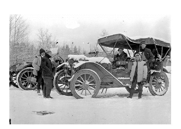
. He and his crew would travel a total of 1,700 miles that season, most of it by raft, but some of them by a relative newcomer to the route into Northern British Columbia, the automobile
Automobile
An automobile, autocar, motor car or car is a wheeled motor vehicle used for transporting passengers, which also carries its own engine or motor...
.
Surveyor General
The Surveyor General is an official responsible for government surveying in a specific country or territory. Originally this would often have been a military appointment, but is now more likely to be a civilian post....
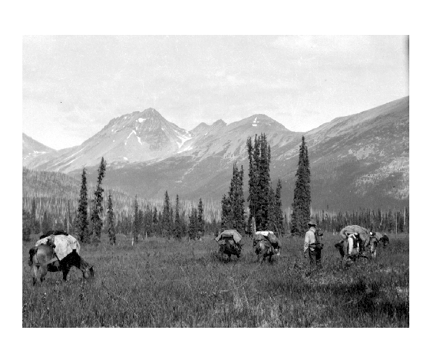
, impressed with Swannell's progress in the Nechako and Omineca regions, sent him back to the area, with the intention of extending his surveys further north and east, further into the Omineca. Swannell resurveyed Mount Pope and Takla Lake and then surveyed the area around Fort Babine, Driftwood River
Driftwood River
The Driftwood River is a tributary of the East Fork of the White River in central Indiana in the United States. Via the White, Wabash and Ohio rivers, it is part of the watershed of the Mississippi River...
and the Omineca River
Omineca River
Omineca River is a river in northern British Columbia, Canada. It flows into the Williston Lake, and is part of the Peace River basin. It was originally a tributary of the Finlay River before the creation of Lake Williston.-References:...
and the Finlay River
Finlay River
The Finlay River is a 402 km long river in north-central British Columbia flowing north and thence south from Thutade Lake in the Omineca Mountains to Williston Lake, the impounded waters of the Peace River formed by the completion of the W.A.C. Bennett Dam in 1968. Prior to this, the Finlay...
. Swannell's party travelled on the North-West Mounted Police Trail that ran between Fort Grahame and Bear Lake. On November 1, they travelled to Burns Lake
Burns Lake, British Columbia
thumb|309px|right|Burns Lake's welcome signBurns Lake is a rural village in the North-Central Interior of British Columbia, Canada, incorporated in 1923...
from Fort St. James, and Swannell observed and photographed the ongoing construction of the Grand Trunk Pacific Railway, before travelling on to Prince Rupert and returning to Victoria.
Peace River (Canada)
The Peace River is a river in Canada that originates in the Rocky Mountains of northern British Columbia and flows to the northeast through northern Alberta. The Peace River flows into the Slave River, a tributary of the Mackenzie River. The Mackenzie is the 12th longest river in the world,...
to Hudson's Hope
Hudson's Hope, British Columbia
Hudson's Hope is a district municipality in northeastern British Columbia, Canada, in the Peace River Regional District. It covers an area of with a population of 1,157 people. Having been first settled in 1805, it is the third oldest community in the province, although it was not incorporated...
and Fort St. John
Fort St. John, British Columbia
The City of Fort St. John is a city in northeastern British Columbia, Canada. A member municipality of the Peace River Regional District, the city covers an area of about 22 km² with 22,000 residents . Located at Mile 47, it is one of the largest cities along the Alaska Highway. Originally...
, eventually arriving at Lesser Slave Lake
Lesser Slave Lake
Lesser Slave Lake is a lake located in central Alberta, Canada, northwest of Edmonton. It is the second largest lake entirely within Alberta boundaries , covering and measuring over long and at its widest point. Lesser Slave Lake averages in depth and is at its deepest...
where they took the steamer Northland Sun to Sawridge, Alberta and then they drove to the train which took them to Edmonton and then continued home by rail.
The Great War
Late in 1914, Swannell enlisted to fight in World War IWorld War I
World War I , which was predominantly called the World War or the Great War from its occurrence until 1939, and the First World War or World War I thereafter, was a major war centred in Europe that began on 28 July 1914 and lasted until 11 November 1918...
and in 1919, joined an anti-Bolshevik
Bolshevik
The Bolsheviks, originally also Bolshevists , derived from bol'shinstvo, "majority") were a faction of the Marxist Russian Social Democratic Labour Party which split apart from the Menshevik faction at the Second Party Congress in 1903....
force in Siberia
Siberia
Siberia is an extensive region constituting almost all of Northern Asia. Comprising the central and eastern portion of the Russian Federation, it was part of the Soviet Union from its beginning, as its predecessor states, the Tsardom of Russia and the Russian Empire, conquered it during the 16th...
where he was wounded in the shoulder.
Bedaux Expedition
Bedaux Expedition
The Bedaux Expedition also named the Bedaux Canadian Subarctic Expedition was an attempt by eccentric French millionaire, Charles Eugène Bedaux to cross the British Columbia wilderness, while making a movie, testing Citroën half-tracks and generating publicity for himself...
of 1934. The expedition was intended to run 2,400 kilometers from Edmonton, Alberta to Telegraph Creek, British Columbia
Telegraph Creek, British Columbia
Telegraph Creek is a small community located off Highway 37 in Northern British Columbia at the confluence of the Stikine River and Telegraph Creek. The only permanent settlement on the Stikine River, it is home to approximately 350 members of the Tahltan First Nation, as well as another 50...
and was led by American, Charles Bedaux
Charles Bedaux
Charles Eugène Bedaux was one of the most colorful millionaires of the early twentieth century. Friends with British royalty and Nazis alike, he amassed a fortune expanding on the Taylorism style of scientific management and was a big game hunter and explorer.-Early years:Charles Bedaux was born...
, who was acquainted with car manufacturer, Andre Citroen
André Citroën
André-Gustave Citroën was a French industrialist. He is remembered chiefly for the make of car named after him, but also for his application of double helical gears.- Life and career :...
, who designed the Kégresse track equipped half-track trucks Bedaux used on his journey. Aside from Beduax and Swannell were fellow mapmaker, Ernest Lemarque, three women: Bedaux's wife, an Italian countess, and a maid, several cameramen, a group of cowboys from Alberta, and the man who would direct the film High Noon
High Noon
High Noon is a 1952 American Western film directed by Fred Zinnemann and starring Gary Cooper and Grace Kelly. The film tells in real time the story of a town marshal forced to face a gang of killers by himself...
, filmmaker, Floyd Crosby
Floyd Crosby
Floyd Delafield Crosby, A.S.C. was an American cinematographer.Crosby was born and raised in West Philadelphia, the son of Julia Floyd and Frederick Van Schoonhoven Crosby...
. Of the five Citroens, two slid off of cliffs, one was sent downriver and the last two were abandoned. The expedition continued on horseback, but in late September, with winter fast approaching and the horses beginning to die of disease and starvation, Bedaux called a halt to the trip just short of their destination.