

Fortress Saint-Maurice
Encyclopedia
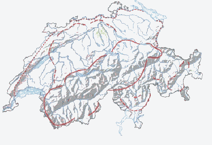
National Redoubt (Switzerland)
The Swiss National Redoubt was a defensive plan developed by the Swiss government beginning in the 1880s to respond to foreign invasion. In the opening years of World War II the plan was expanded and refined to deal with a potential German invasion. The German plan, Operation Tannenbaum, was real,...
. The westernmost of the three, Fortress Saint-Maurice complements Fortress Saint Gotthard and Fortress Sargans to secure the central alpine region
Alps
The Alps is one of the great mountain range systems of Europe, stretching from Austria and Slovenia in the east through Italy, Switzerland, Liechtenstein and Germany to France in the west....
of Switzerland
Switzerland
Switzerland name of one of the Swiss cantons. ; ; ; or ), in its full name the Swiss Confederation , is a federal republic consisting of 26 cantons, with Bern as the seat of the federal authorities. The country is situated in Western Europe,Or Central Europe depending on the definition....
against an invading force. The National Redoubt was first conceived in the 1880s as an easily defensible area to secure the survival of the Swiss Confederation. In the late 1930s and 1940s when neutral
Neutrality (international relations)
A neutral power in a particular war is a sovereign state which declares itself to be neutral towards the belligerents. A non-belligerent state does not need to be neutral. The rights and duties of a neutral power are defined in Sections 5 and 13 of the Hague Convention of 1907...
Switzerland was threatened with invasion from Germany
Operation Tannenbaum
Operation Tannenbaum , known earlier as Operation Green, was a planned but cancelled invasion of Switzerland by Nazi Germany during World War II.-Background:...
, the National Redoubt and its components were modernized and expanded on a massive scale. The fortification system was maintained and upgraded during the Cold War
Cold War
The Cold War was the continuing state from roughly 1946 to 1991 of political conflict, military tension, proxy wars, and economic competition between the Communist World—primarily the Soviet Union and its satellite states and allies—and the powers of the Western world, primarily the United States...
. With the collapse of the Soviet Union
Soviet Union
The Soviet Union , officially the Union of Soviet Socialist Republics , was a constitutionally socialist state that existed in Eurasia between 1922 and 1991....
, the possibility of a Warsaw Pact
Warsaw Pact
The Warsaw Treaty Organization of Friendship, Cooperation, and Mutual Assistance , or more commonly referred to as the Warsaw Pact, was a mutual defense treaty subscribed to by eight communist states in Eastern Europe...
invasion disappeared, and by 1995 many positions were abandoned by the military.
Fortress Saint-Maurice encompasses the area around Saint-Maurice in the western, French-speaking portion of Switzerland. The Rhône
Rhône
Rhone can refer to:* Rhone, one of the major rivers of Europe, running through Switzerland and France* Rhône Glacier, the source of the Rhone River and one of the primary contributors to Lake Geneva in the far eastern end of the canton of Valais in Switzerland...
river leaves the central Alpine region at Saint-Maurice through a narrow defile, between 4000m mountains to the south and 3000m mountains to the north. The only comparatively easy access to the upper Rhône valley, and thus to the western National Redoubt, is through Saint-Maurice. Fortress Saint-Maurice is a series of fortifications set into the mountains on either side of the valley, dominating the region as far as Lac Léman with their artillery. The principal fortification is the enormous Fort de Dailly
Fort de Dailly
The Fort de Dailly is the largest component of Fortress Saint-Maurice, which is in turn one of the three principal fortified regions of the National Redoubt of Switzerland. Almost entirely subterranean, the Fort de Dailly was built in the Massif de Dailly to the east of Saint-Maurice beginning in...
, supported by forts Savartan, Scex
Fort du Scex
The Fort du Scex is a component of Fortress Saint-Maurice, which is in turn one of the three principal fortified regions of the National Redoubt of Switzerland. The Fort du Scex was built in the Scex cliff face immediately to the west of Saint-Maurice beginning in 1911...
and Cindey
Fort de Cindey
The Fort de Cindey is a component of Fortress Saint-Maurice, which is in turn one of the three principal fortified regions of the National Redoubt of Switzerland. The Fort de Cindey was built between 1941 and 1946 in the Scex cliff face immediately to the west of Saint-Maurice to complement the...
, as well as lesser positions. The extent of the area designated as Fortress Saint-Maurice is not clearly defined, but according to the Association Fort de Litroz, the Saint-Maurice sector comprises the Rhône narrows from just north of Saint-Maurice to Martigny, excluding Chillon
Chillón
Chillón is a municipality in Ciudad Real, Castile-La Mancha, Spain. It has a population of 2,271....
and Champillon
Champillon
Champillon is a commune in the Marne department in north-eastern France....
, as well as the fortifications of the lateral valleys.
Concept and organization
Fortress Saint-Maurice is not a single, connected fortified position, but rather a series of mutually supporting self-sufficient fortifications that dominate 10 kilometres (6.2 mi) the Rhône valley between Saint-Maurice and Martigny. The Rhône in this area runs through a deep valley with the classic U-shaped glacial profile. These steep cliff walls, framing a flat valley floor averaging about 1500 metres (4,921.3 ft) wide, create a natural gauntlet. The individual forts are mined as galleries running in the valley walls overlooking the valley and each other. The higher-level forts are accessed by aerial cableways or by inclined funicularFunicular
A funicular, also known as an inclined plane or cliff railway, is a cable railway in which a cable attached to a pair of tram-like vehicles on rails moves them up and down a steep slope; the ascending and descending vehicles counterbalance each other.-Operation:The basic principle of funicular...
s mined within the mountains. Fortress Saint-Maurice bars an enemy moving from France into the central Alps, and to a lesser extent, prevents an enemy crossing the Great Saint Bernard Pass or the Simplon Pass
Simplon Pass
Simplon Pass is a high mountain pass between the Pennine Alps and the Lepontine Alps in Switzerland. It connects Brig in the canton of Valais with Domodossola in Piedmont . The pass itself and the villages on each side of it, such as Gondo, are in Switzerland...
from moving against Lausanne
Lausanne
Lausanne is a city in Romandy, the French-speaking part of Switzerland, and is the capital of the canton of Vaud. The seat of the district of Lausanne, the city is situated on the shores of Lake Geneva . It faces the French town of Évian-les-Bains, with the Jura mountains to its north-west...
. The Saint-Maurice fortifications were supported by additional positions in advance of the main strongpoint, with major forts at Chillon
Fort de Chillon
The Fort de Chillon is a twentieth-century fortification directly adjacent to the medieval Château de Chillon on the edge of Lac Léman in Switzerland. The fort secures the road and rail lines that pass along the lakeshore running east from Lausanne to the mountainous interior of Switzerland...
and Champillon
Fort de Champillon
The Fort de Champillon is a twentieth-century Swiss fortification located in the heights overlooking the Rhône valley from the north between Montreux and Monthey. Completed in 1944, the fort secures the road and rail lines running east from Lausanne to the mountainous interior of Switzerland...
, as well as additional fortifications in side valleys and lesser thoroughfares.
While the Saint-Maurice area has been fortified since medieval times, work on the National Redoubt began in the 1880s with Forts Dailly, Savatan and Scex. World War II and the prospect of invasion by Germany and possibly Italy gave new impetus to the fortification program, causing existing fortifications to be updated and new fortifications to be constructed. In particular, Fort Dailly became one of the largest and most heavily armed fortifications in Switzerland.
Virtually every constriction, bridge, tunnel or other defensible position in the valley was fortified with blockhouses, anti-tank barriers, permanent minefields or pre-surveyed artillery coverage. Industrial facilities, such as the Vezey hydroelectric plant, incorporated fortifications into their construction. All construction was carefully camouflaged using light shells to simulate rock formations, or with a house-shaped superstructure.
The fortifications were maintained and progressively upgraded through the close of the Cold War. By 1995, many were deactivated. The Saint-Maurice fortifications are considered potential historic monuments and have remained in relatively good repair.
Principal fortifications
The Saint-Maurice fortifications are disposed in mutually supporting groups, often with pairs of forts that provide mutual support by direct fireDirect fire
Direct fire refers to the launching of a projectile directly at a target on a relatively flat trajectory. The firing weapon must have a sighting device and an unobstructed line of sight to the target, which means no objects or friendly units can be between it and the target...
as well as supporting more distant parts of the ensemble by means of indirect fire
Indirect fire
Indirect fire means aiming and firing a projectile in a high trajectory without relying on a direct line of sight between the gun and its target, as in the case of direct fire...
. From north to south, the principal components are as follows:
North of Saint-Maurice
Fort de Toveyeres is an infantry fort built to cover the eastern end of the Lavey anti-tank barrier. The barrier, made up of dragon's teeth and a deep ditch, spans the Rhône valley north of Saint-Maurice. The Courset stream runs in the ditch. The tailwater stream from the Lavey hydroelectric station affords an additional barrier, while the power station is itself fortified, with covering fire from the Fort de Cindey.Fort du Petit-Mont is just to the north of Toveyres, providing more cover to the Lavey barrier.
Galerie du Scex and Cindey
The Scex and Cindey fortifications are built into the dramatic Scex escarpment overlooking Saint-Maurice. These two forts, opposite the earlier Savatan and Dailly forts, completed the major portion of the Fortress Saint-Maurice ensemble in the early 20th century. Scex is primarily an artillery fort, which Cindey is a mixed artillery and infantry position. The forts, together with the Grotte aux Fées natural cave, are open to public tours.Fort du Scex
Fort du Scex
The Fort du Scex is a component of Fortress Saint-Maurice, which is in turn one of the three principal fortified regions of the National Redoubt of Switzerland. The Fort du Scex was built in the Scex cliff face immediately to the west of Saint-Maurice beginning in 1911...
(A166) 46°12′50.03"N 6°59′45.62"E comprises part of a fortress complex encased in rock high above the strategic Saint Maurice valley. Scex is connected to Cindey by the natural caves of the Grotte aux Fées. The fort was planned to provide supporting fire to the larger and earlier forts Savatan and Dailly on the right bank of the Rhône. The Galerie du Scex was initially armed with four 75mm guns in 1911. From 1915 it was expanded. The connection to the Grotte aux Fées was built in 1935-36. The Ermitage battery of four 75mm guns was constructed in 1938-39, with further improvements to habitation during and after World War II. The artillery was deactivated in 1984, when the position was converted to use as a command post. By 1995 the fort was entirely deactivated. Routine access to the fort for supplies was provided by an aerial cableway.
Fort de Cindey
Fort de Cindey
The Fort de Cindey is a component of Fortress Saint-Maurice, which is in turn one of the three principal fortified regions of the National Redoubt of Switzerland. The Fort de Cindey was built between 1941 and 1946 in the Scex cliff face immediately to the west of Saint-Maurice to complement the...
(A155) 46°13′14.67"N 7°00′12.44"E was built between 1941 and 1946 and expanded between 1948 and 1952. Located in rock galleries in a northern continuation of the Scex cliff, the fort controlled the narrow defile of the Rhône
Rhône
Rhone can refer to:* Rhone, one of the major rivers of Europe, running through Switzerland and France* Rhône Glacier, the source of the Rhone River and one of the primary contributors to Lake Geneva in the far eastern end of the canton of Valais in Switzerland...
river. The fort was initially armed with two 105mm guns, with four 90mm anti-tank guns and three machine guns added in the 1950s, part of the program begun at Dailly.The fort served until 1995, when it was taken out of service. Power and communications were supplied by Fort de Scex Access for supplies was provided by an aerial ropeway similar to that of Scex.
Savatan-Dailly
The forts at Savatan and Dailly were completed in 1894 and became the central elements of Fortress Saint-Maurice. They were progressively expanded and upgraded through the twentieth century.Fort de Dailly
Fort de Dailly
The Fort de Dailly is the largest component of Fortress Saint-Maurice, which is in turn one of the three principal fortified regions of the National Redoubt of Switzerland. Almost entirely subterranean, the Fort de Dailly was built in the Massif de Dailly to the east of Saint-Maurice beginning in...
(A250) 46°12′24.91"N 7°01′43.31"E is one of the largest and most heavily armed forts in Switzerland, and the central position in Fortress Saint-Maurice. The artillery fort is located on the end of the Dailly massif at a higher level than Savatan. Work began at Dailly in 1892. The entrance to the underground fort lies at 1400 metres (4,593.2 ft) at the end of 29 switchbacks. The fort initially was armed with six 120mm gun turrets with additional open artillery positions. Two 75mm guns were mounted in casemates, while portable 53mm gun turrets occupied prepared surface positions. Dailly was upgraded with 105mm artillery during the 1940s, with as many as ten 105mm guns in casemate positions.
Dailly was the scene of an ammunition explosion on 28 May, 1946, when about 5500 105mm shells, amounting to 449 tons, exploded in three separate magazines successively. The blast threw four 105mm guns from their emplacements and damaged six more. Six construction workers were killed, part of a crew working on a funicular shaft linking Dailly to the upper part of Savatan. The explosion was attributed to decomposition of nitrocellulose propellant. Two similar explosions happened at Grisons in June 1946 and at Blausee-Mitholz in 1947, without loss of life. The damage to Dailly resulted in a comprehensive modernization of the fort, with additions of 81mm and 120mm mortars, removal of obsolete weapons and the installation of two modern 155mm gun turrets. An underground caserne for 650 men was built at this time, with NBC protection. The four 105mm guns of the northern casemates and the two 105mm guns of the central casemate were repaired and upgraded, but the four guns of the south battery were never replaced. The new 155mm gun turrets were mounted on barbettes50 metres (164 ft) deep, with an individual rate of fire of 30 rounds per minute in bursts, or 15 rounds per minute sustained. Design began in 1949, with the first test firings in 1960.
Dailly was deactivated in 1995 and decommissioned in 2003. With the other Saint-Maurice fortifications, it has been designated as a candidate for preservation, but is not open to the public.
Fort de Savatan (A200) 46°12′40.77"N 7°01′15.33"E occupies a shelf on the northwest side of the Dailly massif on the eastern side of the Rhône valley, overlooking Saint-Maurice to the northwest. With up to 1600 troops, the artillery fort mounted five turrets for 120mm guns, a number of 53mm gun turrets and four 84mm guns in caponiers for close defense. Savatan was upgraded at the same time as Dailly, adding an NBC-protected 350-man underground caserne.
South of Saint-Maurice
Fort d'Evionnaz (A80) 46°10′25.63"N 7°01′17.14"E is an infantry fort in rock-cut galleries, designed to support the anti-tank line between Evionnaz and Collognes. The position was garrisoned by an infantry company and extends over four levels. The fort flanks the west side of the "dragon's teeth" anti-tank line that spans the flat floor of the valley. As constructed in 1939, Evionnaz was armed with 47mm anti-tank guns and machine guns. These were upgraded in the 1970s to 90mm guns and improved machine guns. The anti-tank line was planned principally to block an advance from the south toward Lac Léman, rather than the other way around, as most of the area's fortifications were planned.Martigny area
Fort Follatères (A66) 46°07′31.22"N 7°04′02.30"E is located near Martigny on the north side of the Rhône, and a point where the river bend at a right angle and joins the Drance. Follatères was armed with four 75mm guns covering Martigny and two 105mm guns aimed in the direction of the Great Saint Bernard Pass.Fort de Vernayaz (A68/69) complements Follatères on the south side of the Rhône at Vernayaz
Vernayaz
Vernayaz is a municipality in the district of Saint-Maurice, in the canton of Valais, Switzerland.-History:In 1913 the municipality was created when it separated from Salvan.-Geography:...
. The fort occupies a unique location at the mouth of the Trient Gorges overlooking the rail line and Verayaz. The fort is accessed by walkways on the cliffside above the torrent, with footbridges connecting tunnel portals over the water. Materials were delivered by a ropeway. There are three levels of galleries, which are no longer military property. Plans are underway to open the complex to visits by the public.
Present status
Many of the Saint-Maurice fortifications have been deactivated and are considered potential historic monuments. The Forts de Scex and Cindey are open for tours, and plans are being developed to open the Fort de Vernayaz to the public..External links
- www.fort.ch (in German)
- Festung-Oberland.ch (in German)
- Forts de Scex and Cindey
- Photos APSF
- Association Saint-Maurice d'Études Militaires
- Schweizer-Fustungen
- Military monuments in the Valais (in German and French)