
Fort Rock Basin
Encyclopedia
Portions of this article include public domain
text from the USFS Deschutes & Ochoco National Forests - Crooked River National Grassland.
The Fort Rock-Christmas Lake Valley Basin is the basin of a former inland sea that existed in that region from Pliocene
through late Pleistocene
time.
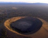
The Fort Rock basin maar field includes over 30 hydrovolcanic landforms spread over an area of 1500 square mile.
probably encountered permeable aquifers beneath the cone. A line of tuff rings between Moffitt Butte and the Fort Rock-Christmas Lake Valley Basin are located roughly along what would have been an early drainage route between the Fort Rock Basin and the La Pine Basin. The crater floor of Moffitt Butte is about 260 foot above the surrounding plain. A smaller vent and small tuff ring, 1700 foot in diameter, are located on Moffitt Butte's southwestern flank. The crater of the smaller vent is filled with lava
that issued from a dike
on its northwest edge.
which once filled the crater, but erosion has modified the original cone, exposing the once ponded basalt lava lake
. Dikes extend north and south of the crater's lava lake. On the lower flanks of the cone, the rocks are mostly palagonite
lapilli-tuff
. Near the summit, the uppermost palagonites are overlain by massive cinders and bombs
from fire-fountaining that preceded the filling of the crater with lava.
Public domain
Works are in the public domain if the intellectual property rights have expired, if the intellectual property rights are forfeited, or if they are not covered by intellectual property rights at all...
text from the USFS Deschutes & Ochoco National Forests - Crooked River National Grassland.
The Fort Rock-Christmas Lake Valley Basin is the basin of a former inland sea that existed in that region from Pliocene
Pliocene
The Pliocene Epoch is the period in the geologic timescale that extends from 5.332 million to 2.588 million years before present. It is the second and youngest epoch of the Neogene Period in the Cenozoic Era. The Pliocene follows the Miocene Epoch and is followed by the Pleistocene Epoch...
through late Pleistocene
Pleistocene
The Pleistocene is the epoch from 2,588,000 to 11,700 years BP that spans the world's recent period of repeated glaciations. The name pleistocene is derived from the Greek and ....
time.
The Fort Rock basin maar field includes over 30 hydrovolcanic landforms spread over an area of 1500 square mile.
Moffitt Butte
Moffitt Butte is a dissected basaltic tuff ring, 4600 feet (1,402.1 m) in diameter and 400 feet (122 m). Moffitt Butte is not associated with a lake basin, as is the case for Fort Rock and Hole-in-the-Ground, but rising magmaMagma
Magma is a mixture of molten rock, volatiles and solids that is found beneath the surface of the Earth, and is expected to exist on other terrestrial planets. Besides molten rock, magma may also contain suspended crystals and dissolved gas and sometimes also gas bubbles. Magma often collects in...
probably encountered permeable aquifers beneath the cone. A line of tuff rings between Moffitt Butte and the Fort Rock-Christmas Lake Valley Basin are located roughly along what would have been an early drainage route between the Fort Rock Basin and the La Pine Basin. The crater floor of Moffitt Butte is about 260 foot above the surrounding plain. A smaller vent and small tuff ring, 1700 foot in diameter, are located on Moffitt Butte's southwestern flank. The crater of the smaller vent is filled with lava
Lava
Lava refers both to molten rock expelled by a volcano during an eruption and the resulting rock after solidification and cooling. This molten rock is formed in the interior of some planets, including Earth, and some of their satellites. When first erupted from a volcanic vent, lava is a liquid at...
that issued from a dike
Dike (geology)
A dike or dyke in geology is a type of sheet intrusion referring to any geologic body that cuts discordantly across* planar wall rock structures, such as bedding or foliation...
on its northwest edge.
Table Rock
Table Rock is an erosional remnant of a tuff cone, which at present is a symmetrical cone about 5020 foot in diameter at the base, tapering to a diameter of about 1180 foot at a height of 1180 foot above the surrounding plain. The cone is capped with flat-lying basaltBasalt
Basalt is a common extrusive volcanic rock. It is usually grey to black and fine-grained due to rapid cooling of lava at the surface of a planet. It may be porphyritic containing larger crystals in a fine matrix, or vesicular, or frothy scoria. Unweathered basalt is black or grey...
which once filled the crater, but erosion has modified the original cone, exposing the once ponded basalt lava lake
Lava lake
Lava lakes are large volumes of molten lava, usually basaltic, contained in a volcanic vent, crater, or broad depression. The term is used to describe both lava lakes that are wholly or partly molten and those that are solidified...
. Dikes extend north and south of the crater's lava lake. On the lower flanks of the cone, the rocks are mostly palagonite
Palagonite
Palagonite is an alteration product from the interaction of water with volcanic glass of chemical composition similar to basalt. Palagonite can also result from the interaction between water and basalt melt...
lapilli-tuff
Lapilli
Lapilli is a size classification term for tephra, which is material that falls out of the air during a volcanic eruption or during some meteorite impacts. Lapilli means "little stones" in Latin. They are in some senses similar to ooids or pisoids in calcareous sediments.By definition lapilli range...
. Near the summit, the uppermost palagonites are overlain by massive cinders and bombs
Volcanic bomb
A volcanic bomb is a mass of molten rock larger than 65 mm in diameter, formed when a volcano ejects viscous fragments of lava during an eruption. They cool into solid fragments before they reach the ground. Because volcanic bombs cool after they leave the volcano, they do not have grains...
from fire-fountaining that preceded the filling of the crater with lava.
Notable Vents
| Name | Elevation | Location | Last eruption |
| Big Hole Big Hole (Oregon) Big Hole is a large maar in the Fort Rock Basin of Lake County, central Oregon, northeast of Crater Lake, near Oregon Route 31. It is approximately 6000 ft across and deep.... |
- | - | possibly 20,000 years ago |
| Black Hills (Oregon) Black Hills (Oregon) The Black Hills are a mountain range in Lake County, Oregon. They are located to the immediate south of the community of Christmas Valley; just off of Old Lake Highway.... |
- | - | - |
| Boat-Wright Ranch | - | - | - |
| Flat Top Flat Top Flat Top, with an elevation of 4,142 feet, is the 20th-highest peak in Georgia. It is located in Rabun County, Georgia and is within the boundaries of the Chattahoochee National Forest. There is a view of the rock face of Flat Top from the Bartram Trail.... |
- | - | - |
| Flatiron | - | - | - |
| Fort Rock | - | 43.37°N 121.06°W | 50,000 to 100,000 years ago |
| Hole-in-the-Ground Hole-in-the-Ground Hole-in-the-Ground is a large maar in the Fort Rock Basin of Lake County, central Oregon, northeast of Crater Lake, near Oregon Route 31.... |
- | 43.41°N 121.20°W | 50,000 to 100,000 years ago |
| Horning Bend | - | - | - |
| Moffitt Butte | - | 43.51°N 121.44°W | 50,000 to 100,000 years ago |
| Reed Rock | - | - | - |
| Ridge 28 | - | - | - |
| St. Patrick Mountain | - | - | - |
| Sand Rock | - | 43.37°N 120.32°W | 50,000 to 100,000 years ago |
| Seven-Mile Ridge | - | - | - |
| South Green Mountain | - | - | - |
| Table Mountain | - | - | - |
| Table Rock Upper and Lower Table Rock Upper Table Rock and Lower Table Rock are two prominent volcanic plateaus located just north of the Rogue River in Jackson County, Oregon. Created by an andesitic lava flow approximately seven million years ago and shaped by erosion, they now stand about above the surrounding valley... |
- | 43.17°N 120.88°W | 50,000 to 100,000 years ago |
| Wastina Butte | - | - | - |
| Wildcat Butte | - | - | - |