

Foots Cray Meadows
Encyclopedia
London Borough of Bexley
The London Borough of Bexley lies in south east Greater London, and is a borough referred to as part of Outer London. It has common borders with the London Borough of Bromley to the south, the London Borough of Greenwich to the west, across the River Thames to the north it borders the London...
, England
England
England is a country that is part of the United Kingdom. It shares land borders with Scotland to the north and Wales to the west; the Irish Sea is to the north west, the Celtic Sea to the south west, with the North Sea to the east and the English Channel to the south separating it from continental...
. It borders the suburbs of Albany Park, Sidcup
Sidcup
Sidcup is a district in South East London in the London Borough of Bexley and small parts of the district in the London Borough of Greenwich.Located south east of Charing Cross, Sidcup is bordered by the London Boroughs of Greenwich and Bromley and Kent County Council, and whilst now part of...
, Foots Cray
Foots Cray
Foots Cray is a place in the London Borough of Bexley, near the town of Sidcup, in southeast London, England, United Kingdom.It took its name from Godwin Fot, a local Saxon landowner recorded in the Domesday Book of 1086, and from the River Cray that passes through the village. It lay on the old...
, and North Cray
North Cray
North Cray is a place in the London Borough of Bexley, southeast London, England, east southeast of Charing Cross. It lies on the River Cray and is in the Cray Meadows electoral ward which also includes Foots Cray...
. The River Cray
River Cray
The River Cray is a tributary of the River Darent in southern England. It rises in Priory Gardens in Orpington in the London Borough of Bromley, where rainwater permeates the chalk bedrock and forms a pond at the boundary between the chalk and impermeable clay...
runs through it in a north-easterly direction. The London Loop, a public recreational walking path around London, also known as the "M25 for walkers", runs through the meadows parallel to the river from Sidcup Place, just south of the meadows.
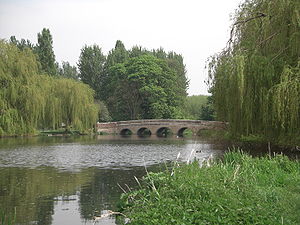
A notable feature of the area is the Five Arches bridge, which crosses the River Cray, as does the smaller Penny Farthing Bridge.
The Meadows are a Local Nature Reserve
Local Nature Reserve
Local nature reserve or LNR is a designation for nature reserves in the United Kingdom. The designation has its origin in the recommendations of the Wild Life Conservation Special Committee which established the framework for nature conservation in the United Kingdom and suggested a national suite...
and have received a Green Flag Award
Green Flag Award
The Green Flag Award is the benchmark national standard for parks and green spaces in the United Kingdom. The scheme was set up in 1996 to recognise and reward green spaces in England and Wales that met the laid down high standards...
. There is access from Rectory Lane, among other places.
Adjacent to the meadows is an area known locally as the "wasteland" and the ruins of a destroyed boules
Boules
Boules is a collective name for games played with metal balls.Two of the most played boule games are pétanque and boule lyonnaise. The aim of the game is to get large, heavy balls as close to the 'jack' as you can. It is very popular especially in France, but also Italy, where it may often be seen...
alley.
History
The area was originally a part of the Footscray Place estate, and during the 18th century the Five Arches bridge was built. At the same time, an almshouse was built adjacent to the woods, which, as of 2008, was being excavated by archaeologistsArchaeology
Archaeology, or archeology , is the study of human society, primarily through the recovery and analysis of the material culture and environmental data that they have left behind, which includes artifacts, architecture, biofacts and cultural landscapes...
belonging to Bexley Archaeological Group.
After the house's destruction, in the late 1940s, the area was turned into a public recreation park. In the early 2000s, Five Arches bridge was renovated with new stone.