
.gif)
Five Points (MARTA station)
Encyclopedia
Five Points is a tri-level underground multi-platform metro station
of the Metropolitan Atlanta Rapid Transit Authority
(MARTA) rail system. It is the transfer point between the Red
and Gold
Lines and the Blue
and Green
Lines and serves as MARTA's transportation hub. It provides access to the Five Points Business District
, Underground Atlanta
, City Hall, the Richard B. Russell Federal Building
, Atlanta Visitors Bureau, The Braves Shuttle, Cobb Community Transit, Gwinnett County Transit, GRTA Xpress Transit, and the tourism heart of Downtown Atlanta
. It provides Connecting bus service To: The City of Atlanta, South Fulton, Fulton, South Dekalb, and South Cobb Counties.
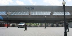
 The station is composed of three levels, and an additional plaza level. At the surface is the plaza level, which provides access to the concourse level, Alabama Street, and shopping along a pedestrian only portion of Broad Street. The plaza level also houses the MARTA police precinct. The plaza level connect to the concourse level, which has the faregates and provides access to the rail platforms. Outside the paid area are the MARTA Ride Store, Half Fare Office, and Lost and Found, and a Zip car location. Outside the faregates is a tunnel to Underground Atlanta
and stairs to Peachtree Street
, Alabama Street, and Forsyth Street. Within the faregates are restrooms, and information kiosk, and stairs to the platforms. Directly underneath the concourse level is the Blue Line
and Green Line
platform. Running underneath and perpendicular to the Blue/Green platform is the Red Line
and Gold Line
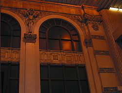
platform. At the end of the platform is the original facade of the Eiseman Building, which was demolished to make way for the station; however, the facade is more visible from the Blue/Green platform. Elevators provide disabled access to all levels of the station. This is the busiest station in the MARTA system, handling an average of 57,000 people per business day, and over 27,000 on weekends.
Major renovations to both the east and west street-level plazas of the station began in April 2006.
Metro station
A metro station or subway station is a railway station for a rapid transit system, often known by names such as "metro", "underground" and "subway". It is often underground or elevated. At crossings of metro lines, they are multi-level....
of the Metropolitan Atlanta Rapid Transit Authority
Metropolitan Atlanta Rapid Transit Authority
The Metropolitan Atlanta Rapid Transit Authority or MARTA is the principal rapid-transit system in the Atlanta metropolitan area and the ninth-largest in the United States. Formed in 1971 as strictly a bus system, MARTA operates a network of bus routes linked to a rapid transit system consisting...
(MARTA) rail system. It is the transfer point between the Red
Red Line (MARTA)
The Red Line is a rapid transit line in the MARTA rail system. It operates between North Springs and Airport stations, running through Sandy Springs, Atlanta, East Point and College Park....
and Gold
Gold Line (MARTA)
The Gold Line is a rapid transit line in the MARTA rail system. It operates between Doraville and Airport stations, running through Doraville, Chamblee, Atlanta, East Point and College Park....
Lines and the Blue
Blue Line (MARTA)
The Blue Line is a rapid transit line in the MARTA rail system. It operates between Hamilton E. Holmes and Indian Creek stations, running through Atlanta, Decatur and portions of unincorporated DeKalb County....
and Green
Green Line (MARTA)
The Green Line is a rapid transit line in the MARTA rail system. It operates between Bankhead and Edgewood/Candler Park stations, running exclusively inside the Atlanta city limits....
Lines and serves as MARTA's transportation hub. It provides access to the Five Points Business District
Five Points (Atlanta)
Five Points is a district of Atlanta, Georgia, United States, the primary reference for the downtown area. The name refers to the convergence of Marietta Street, Edgewood Avenue, Decatur Street, and two legs of Peachtree Street Five Points is a district of Atlanta, Georgia, United States, the...
, Underground Atlanta
Underground Atlanta
Underground Atlanta is a shopping and entertainment district in the Five Points neighborhood of downtown Atlanta, Georgia, United States, near the intersection of the east and west MARTA rail lines. First opened in 1969, it takes advantage of the viaducts built over the city's many railroad tracks...
, City Hall, the Richard B. Russell Federal Building
Richard B. Russell Federal Building
The Richard B. Russell Federal Building is a 26-storey International style building in Atlanta, Georgia housing U.S. government agency offices and federal courts.-External links:*...
, Atlanta Visitors Bureau, The Braves Shuttle, Cobb Community Transit, Gwinnett County Transit, GRTA Xpress Transit, and the tourism heart of Downtown Atlanta
Downtown Atlanta
Downtown Atlanta is the first and largest of the three financial districts in the city of Atlanta. Downtown Atlanta is the location of many corporate or regional headquarters, city, county, state and federal government facilities, sporting facilities, and is the central tourist attraction of the city...
. It provides Connecting bus service To: The City of Atlanta, South Fulton, Fulton, South Dekalb, and South Cobb Counties.
Station complex
Underground Atlanta
Underground Atlanta is a shopping and entertainment district in the Five Points neighborhood of downtown Atlanta, Georgia, United States, near the intersection of the east and west MARTA rail lines. First opened in 1969, it takes advantage of the viaducts built over the city's many railroad tracks...
and stairs to Peachtree Street
Peachtree Street
Peachtree Street is the main street of Atlanta. The city grew up around the street, and many of its historical and municipal buildings are or were located along it...
, Alabama Street, and Forsyth Street. Within the faregates are restrooms, and information kiosk, and stairs to the platforms. Directly underneath the concourse level is the Blue Line
Blue Line (MARTA)
The Blue Line is a rapid transit line in the MARTA rail system. It operates between Hamilton E. Holmes and Indian Creek stations, running through Atlanta, Decatur and portions of unincorporated DeKalb County....
and Green Line
Green Line (MARTA)
The Green Line is a rapid transit line in the MARTA rail system. It operates between Bankhead and Edgewood/Candler Park stations, running exclusively inside the Atlanta city limits....
platform. Running underneath and perpendicular to the Blue/Green platform is the Red Line
Red Line (MARTA)
The Red Line is a rapid transit line in the MARTA rail system. It operates between North Springs and Airport stations, running through Sandy Springs, Atlanta, East Point and College Park....
and Gold Line
Gold Line (MARTA)
The Gold Line is a rapid transit line in the MARTA rail system. It operates between Doraville and Airport stations, running through Doraville, Chamblee, Atlanta, East Point and College Park....
platform. At the end of the platform is the original facade of the Eiseman Building, which was demolished to make way for the station; however, the facade is more visible from the Blue/Green platform. Elevators provide disabled access to all levels of the station. This is the busiest station in the MARTA system, handling an average of 57,000 people per business day, and over 27,000 on weekends.
Construction
Design and engineering begin in 1973, existing properties were acquired and demolished in 1974-1975, and actual construction begin in early 1976. The station was constructed using the cut-and-cover method. The Gold Line (then called North-South line) was built beneath Broad Street, and the Blue Line (then called East-West line) was constructed next to the railroad freight lines that run through Downtown Atlanta. Five Points Station opened on December 22, 1979 with the original East-West platform open only. The initial opening of the station was almost delayed because of construction on the lower level. The North-South platform did not open until December 4, 1981.Major renovations to both the east and west street-level plazas of the station began in April 2006.
Attractions
- Underground AtlantaUnderground AtlantaUnderground Atlanta is a shopping and entertainment district in the Five Points neighborhood of downtown Atlanta, Georgia, United States, near the intersection of the east and west MARTA rail lines. First opened in 1969, it takes advantage of the viaducts built over the city's many railroad tracks...
- City Hall
- Fulton County AnnexFulton County, GeorgiaFulton County is a county located in the U.S. state of Georgia. Its county seat is Atlanta, the state capital since 1868 and the principal county of the Atlanta metropolitan area...
- Richard B. Russell Federal BuildingRichard B. Russell Federal BuildingThe Richard B. Russell Federal Building is a 26-storey International style building in Atlanta, Georgia housing U.S. government agency offices and federal courts.-External links:*...
- Five Points (Atlanta)Five Points (Atlanta)Five Points is a district of Atlanta, Georgia, United States, the primary reference for the downtown area. The name refers to the convergence of Marietta Street, Edgewood Avenue, Decatur Street, and two legs of Peachtree Street Five Points is a district of Atlanta, Georgia, United States, the...
Bus routes
- Route 1 - Centennial Olympic ParkCentennial Olympic ParkCentennial Olympic Park is a 21 acre public park located in downtown Atlanta, Georgia, USA that is owned and operated by the Georgia World Congress Center Authority. The park was built by the Atlanta Committee for the Olympic Games as part of the infrastructure improvements for the Centennial...
/ Coronet Way - Route 3 - Martin Luther King Jr. Drive / Auburn Avenue
- Route 13 - Fair Street / Mozley Park
- Route 16 - Noble
- Route 32 - Bouldercrest / Georgia AquariumGeorgia AquariumThe Georgia Aquarium, located in Atlanta, Georgia, United States, at Pemberton Place, is the world's largest aquarium with more than of marine and fresh water housing more than 120,000 animals of 500 different species...
- Route 42 - Pryor Road / McDainel Street
- Route 49 - McDonough Boulevard
- Route 51 - Joseph E Boone Boulevard / Dixie Hills
- Route 55 - Jonesboro Road / Hutchens Road
- Route 74 - Flat Shoals
- Route 110 - Peachtree Street "The Peach"
- Route 155 - Windsor Street / Lakewood Avenue
- Route 186 - Rainbow Drive / South DeKalb
- Braves Shuttle
Connection to other transit systems
- Cobb Community TransitCobb Community TransitCobb Community Transit or CCT is the bus public transit system in Cobb County, Georgia, one of metro Atlanta's three most populous suburban counties...
- Gwinnett County TransitGwinnett County TransitGwinnett County Transit or GCT is the bus public transit system in Gwinnett County, Georgia, USA, one of metro Atlanta's three most populous suburban counties...
- Georgia Regional Transportation AuthorityGeorgia Regional Transportation AuthorityThe Georgia Regional Transportation Authority or GRTA is a government agency in the U.S. state of Georgia...