

Fish Creek Mountains Wilderness
Encyclopedia
Brawley, California
Brawley is a city in Imperial County, California, United States. Brawley is located north of El Centro. The population was 24,953 at the 2010 census, up from 22,052 at the 2000 census. The town has a significant cattle and feed industry, and hosts the annual Cattle Call Rodeo. Year-round...
, and southeast of the Vallecito Mountains
Vallecito Mountains
The Vallecito Mountains are located in southern California about north of the U.S. border with Mexico. The mountains lie in Anza-Borrego Desert State Park in an east-west direction southwest of the community of Ocotillo Wells, and south of Highway 78...
in the United States
United States
The United States of America is a federal constitutional republic comprising fifty states and a federal district...
. The wilderness is located in the Fish Creek Mountains
Fish Creek Mountains
The Fish Creek Mountains are a mountain range in Lander County, Nevada....
region in the northern part of the Carrizo Impact Area
Carrizo Impact Area
The Carrizo Impact Area was used by the United States Navy as an air-to-ground bombing range during World War II and the Korean War. It is in the Anza-Borrego Desert in south central California and covers about . The majority of the range is in Anza-Borrego Desert State Park and about a third is...
, which is closed to the public.
Geography
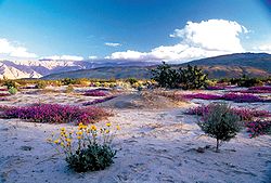
The Fish Creek Mountains resemble a plateau rising as a great wall above the desert basin. From a distance, few dramatic peaks are visible. However, on closer examination, a rugged land of jagged ridges and peaks appears above twisting canyons and small valleys, creating a pristine natural environment. The steep mountain slopes contain limestone outcrops that have resisted erosion. As a result, water from cloudbursts has created narrow chutes swirling with water. Shielded from the sun's evaporating rays, water at the base of these chutes remains year-round serving wildlife as natural tanks. A portion of the ancient Lake Cahuilla shoreline is visible within this wilderness. The lake was a great body of freshwater once covering the Imperial and Coachella Valleys, receding 500 years ago.Visiting
Camping is permitted outside of the Carrizo Impact Area, but is limited to 14 days. After 14 days, campers must relocate at least 25 miles (40 km) from previous site. The wilderness covers 21425 acres (86.7 km²). It is south of Anza-Borrego Desert State ParkAnza-Borrego Desert State Park
Anza-Borrego Desert State Park is a state park located within the Colorado Desert of Southern California. The park takes its name from 18th century, Spanish explorer Juan Bautista de Anza and borrego, the Spanish word for bighorn sheep...
in the Colorado Desert
Colorado Desert
California's Colorado Desert is a part of the larger Sonoran Desert, which extends across southwest North America. The Colorado Desert region encompasses approximately , reaching from the Mexican border in the south to the higher-elevation Mojave Desert in the north and from the Colorado River in...
, and west of the Imperial Valley
Imperial Valley
The Imperial Valley is an agricultural area of Southern California's Imperial County. It is located in southeastern Southern California, centered around the city of El Centro. Locally, the terms "Imperial Valley" and "Imperial County" are used synonymously. The Valley is bordered between the...
.
l