
Ferny Creek Trail
Encyclopedia
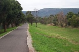
The Ferny Creek Trail is a shared use path for cyclists
and pedestrian
s, which follows Ferny and Corhanwarrabul Creeks through the suburbs of Knoxfield
and Ferntree Gully
in Melbourne
, Victoria
, Australia
.
Bicycle Victoria
is campaigning for a connection between the Dandenong Creek Trail
and the western end of the Ferny Creek Trail at Stud Road. The path would have to be extended along Corhanwarrabul Creek beside the Caribbean Gardens
. The connection is also as proposed by Parks Victoria
and support for the project is ALP policy. An underpass would have to be built as part of the EastLink
project.
Ferny and Monbulk creeks combine to become the Corhanwarrabul Creek, 1.2 km east of Stud Road.
runs beside Kings Park along Forest Oak Drive south west of and close to Upper Ferntree Gully Station. Forest Oak Drive turns to the east with a 90 degree bend, at the north end of the park. At the bend go straight ahead for the Ferny Creek trail and for the Belgrave Rail Trail
turn to the right and head for the pedestrian lights at Burwood Highway
.
Within 100m the trail starts to run parallel to Acacia Road. After the far end of Acacia Road, the trail is straightforward. About 4.7km from the start is an intersection with a rough track that quickly leads to Scoresby Road. The point is marked by one of the many pieces of art dedicated to Hubert Opperman
, that are found in the City of Knox
. See also the Oppy Family Fun Ride
.
Another 2.1 km and the trail reaches Stud Road after a nice run in pleasant surroundings.
Turn right (north) and continue on the Stud Road path to Ferntree Gully Road. At Ferntree Gully Road, using the path on the north side of the road, head west to arrive at the EastLink Trail
.
West end at 37.902702°S 145.214301°E.
East end at 37.893094°S 145.301510°E.
Cycling
Cycling, also called bicycling or biking, is the use of bicycles for transport, recreation, or for sport. Persons engaged in cycling are cyclists or bicyclists...
and pedestrian
Pedestrian
A pedestrian is a person traveling on foot, whether walking or running. In some communities, those traveling using roller skates or skateboards are also considered to be pedestrians. In modern times, the term mostly refers to someone walking on a road or footpath, but this was not the case...
s, which follows Ferny and Corhanwarrabul Creeks through the suburbs of Knoxfield
Knoxfield, Victoria
Knoxfield is a suburb in Melbourne, Victoria, Australia, 27 km south-east from Melbourne's central business district. Its Local Government Area is the City of Knox...
and Ferntree Gully
Ferntree Gully, Victoria
Ferntree Gully is a suburb in Melbourne, Victoria, Australia, in the Dandenong Ranges, 29 km east from Melbourne's central business district. It is in the Local Government Area's of the Shire of Yarra Ranges and the City of Knox...
in Melbourne
Melbourne
Melbourne is the capital and most populous city in the state of Victoria, and the second most populous city in Australia. The Melbourne City Centre is the hub of the greater metropolitan area and the Census statistical division—of which "Melbourne" is the common name. As of June 2009, the greater...
, Victoria
Victoria (Australia)
Victoria is the second most populous state in Australia. Geographically the smallest mainland state, Victoria is bordered by New South Wales, South Australia, and Tasmania on Boundary Islet to the north, west and south respectively....
, Australia
Australia
Australia , officially the Commonwealth of Australia, is a country in the Southern Hemisphere comprising the mainland of the Australian continent, the island of Tasmania, and numerous smaller islands in the Indian and Pacific Oceans. It is the world's sixth-largest country by total area...
.
Bicycle Victoria
Bicycle Victoria
Bicycle Network Victoria is a community-based not-for-profit organisation, one of the largest cycling membership organisations in the world , whose mission is to get More People Cycling More Often. The name was changed from Bicycle Victoria to Bicycle Network Victoria in July 2011...
is campaigning for a connection between the Dandenong Creek Trail
Dandenong Creek Trail
The Dandenong Creek Trail is a shared use path for cyclists and pedestrians, which follows Dandenong Creek through the outer eastern and south-eastern suburbs of Melbourne, Victoria, Australia.-Following the Path:...
and the western end of the Ferny Creek Trail at Stud Road. The path would have to be extended along Corhanwarrabul Creek beside the Caribbean Gardens
Caribbean Gardens
Caribbean Gardens is a market and gardens located in the outer eastern suburb of Scoresby in Melbourne, Australia. It is one of the largest privately run markets in Australia and has been operating since the late 1960s....
. The connection is also as proposed by Parks Victoria
Parks Victoria
-Department:Parks Victoria was established in December 1996 as a statutory authority, reporting to the Minister for Environment and Climate Change. The Parks Victoria Act 1998 makes Parks Victoria responsible for managing national parks, reserves and other land under the control of the state,...
and support for the project is ALP policy. An underpass would have to be built as part of the EastLink
EastLink, Melbourne
EastLink is a A$2.5 billion tolled freeway linking a large area through the eastern and south-eastern suburbs of Melbourne, Australia. It is a part of Melbourne's Metropolitan Ring Road project....
project.
Ferny and Monbulk creeks combine to become the Corhanwarrabul Creek, 1.2 km east of Stud Road.
Following the path
The Belgrave Rail TrailBelgrave Rail Trail
The Ringwood - Belgrave Rail Trail is a shared-use path for cyclists and pedestrians, which follows the Belgrave railway line from the Mullum Mullum Creek Trail in Ringwood to Belgrave railway station in Belgrave, in the outer eastern suburbs of Melbourne, Victoria, Australia.This trail is known to...
runs beside Kings Park along Forest Oak Drive south west of and close to Upper Ferntree Gully Station. Forest Oak Drive turns to the east with a 90 degree bend, at the north end of the park. At the bend go straight ahead for the Ferny Creek trail and for the Belgrave Rail Trail
Belgrave Rail Trail
The Ringwood - Belgrave Rail Trail is a shared-use path for cyclists and pedestrians, which follows the Belgrave railway line from the Mullum Mullum Creek Trail in Ringwood to Belgrave railway station in Belgrave, in the outer eastern suburbs of Melbourne, Victoria, Australia.This trail is known to...
turn to the right and head for the pedestrian lights at Burwood Highway
Burwood Highway
Burwood Highway is a major transportation link with Melbourne's eastern suburbs. It begins in the suburb of Kooyong, Melbourne at the junction of the Monash Freeway as Toorak Road between Monash Freeway and Warrigal Road, and finishes in Belgrave, Victoria in the Dandenong Ranges...
.
Within 100m the trail starts to run parallel to Acacia Road. After the far end of Acacia Road, the trail is straightforward. About 4.7km from the start is an intersection with a rough track that quickly leads to Scoresby Road. The point is marked by one of the many pieces of art dedicated to Hubert Opperman
Hubert Opperman
Sir Hubert Ferdinand Opperman, OBE , referred to as Oppy by Australian and French crowds, was an Australian cyclist and politician, whose endurance cycling feats in the 1920s and 1930s earned him international acclaim....
, that are found in the City of Knox
City of Knox
The City of Knox is a Local Government Area in Victoria, Australia, located in the eastern suburbs of Melbourne. It has an area of and has a estimated population of 155,969 people.-History:...
. See also the Oppy Family Fun Ride
Oppy Family Fun Ride
A non competitive ride held in City of Knox, Melbourne, Australia, by the Knox City Council, in the memory of Hubert Opperman, who resided in Knox just before his death in 1996....
.
Another 2.1 km and the trail reaches Stud Road after a nice run in pleasant surroundings.
Turn right (north) and continue on the Stud Road path to Ferntree Gully Road. At Ferntree Gully Road, using the path on the north side of the road, head west to arrive at the EastLink Trail
EastLink Trail
The EastLink Trail is a shared use path for cyclists and pedestrians, which follows the EastLink tollway for most of its length from Ringwood to Dandenong, in the outer eastern suburbs of Melbourne, Victoria, Australia.-Following the path:...
.
Connections
- Connects to the Belgrave Rail TrailBelgrave Rail TrailThe Ringwood - Belgrave Rail Trail is a shared-use path for cyclists and pedestrians, which follows the Belgrave railway line from the Mullum Mullum Creek Trail in Ringwood to Belgrave railway station in Belgrave, in the outer eastern suburbs of Melbourne, Victoria, Australia.This trail is known to...
in the east. - At Knox park, one can use a decrepit path along Scoresby Road, that leads to the Blind Creek TrailBlind Creek TrailThe Blind Creek Trail is a shared-use path for cyclists and pedestrians, which follows the Blind Creek from the Dandenong Creek Trail in Wantirna South to the Ringwood - Belgrave Rail Trail in Boronia, in the outer eastern suburbs of Melbourne, Victoria, Australia.This trail is one of the major...
in the north. - Connects to EastLink TrailEastLink TrailThe EastLink Trail is a shared use path for cyclists and pedestrians, which follows the EastLink tollway for most of its length from Ringwood to Dandenong, in the outer eastern suburbs of Melbourne, Victoria, Australia.-Following the path:...
and Dandenong Creek TrailDandenong Creek TrailThe Dandenong Creek Trail is a shared use path for cyclists and pedestrians, which follows Dandenong Creek through the outer eastern and south-eastern suburbs of Melbourne, Victoria, Australia.-Following the Path:...
in the west.
West end at 37.902702°S 145.214301°E.
East end at 37.893094°S 145.301510°E.