
Farm to Market Road 1
Encyclopedia
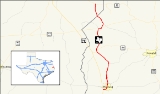
Farm to Market Road 1, or FM 1, is a farm-to-market road, a state maintained road which serves to connect rural and agricultural areas to market towns, in the U.S. state
of Texas
. The road was the first farm-to-market road to be designated in Texas at the request of local industry for a paved road. The 18.6 miles (29.9 km) road provides access to rural areas of East Texas
from U.S. Highway 96.
northward to Magasco from its inception in 1941 until 1954 when FM 1776 was cancelled and combined with FM 1. Also, FM 1 was rerouted and its old route became a spur connection to Magasco. Throughout its history the road has predominantly served the logging industry.
at a junction with U.S. Highway 96. In Pineland, FM 1 is known as Temple Avenue and travels eastward and then northward through the town. North of Pineland, the road's name changes to Magasco Drive as it travels northward to the town of Magasco. Just south of Magasco, FM 1 has a short spur that travels on the west side of the BNSF Railway
tracks as the main road crosses the tracks and parallels the spur to the east of the tracks.
FM 1 continues northward through Sabine County then turns to a more northwesterly route after its junction with FM 2024. FM 1 is known as North Temple Road as it enters the town of Bronson
. A short break occurs in the road as it intersects SH 184
in Bronson. FM 1 begins again at a point farther north on SH 184 and heads north as Bronson Road.
FM 1 heads north from Bronson until it intersects with SH 103 west of Rosevine
. At this point another break in the road occurs. FM 1 begins again at a point farther east along SH 103. The road heads to the northeast and is known as Rosevine Road. The road changes course to the north-northwest after a junction with FM 1592. FM 1 leaves Sabine County northwest of Rosevine. Only a couple of miles of FM 1 exist in San Augustine County
. The road enters the northeastern portion of the county heading north until it terminates at State Highway 21 at Fords Corner.
|rowspan=11|Sabine
|rowspan=3|Pineland
|0.0
|
|
|-
|0.7
|
|
|-
|1.1
|
|
|-
|
|5.8
|
|
|-
|rowspan=3|Bronson
|8.8
|
|SH 184 continues to the west and north
|-
!colspan=3|Break in route at SH 184
|-
|8.8
|
|FM 1 continues to the north
SH 184 continues to the east
|-
|
|13.4
|
|SH 103 continues to the east and west
FM 3229 continues to the north
|-
|
!colspan=3|Break in route at SH 103
|-
|
|13.4
|
|FM 1 continues to the north-northeast
SH 103 continues to the east-northeast
|-
|Rosevine
|14.4
|
|
|-
|San Augustine
|
|18.6
|
|
U.S. state
A U.S. state is any one of the 50 federated states of the United States of America that share sovereignty with the federal government. Because of this shared sovereignty, an American is a citizen both of the federal entity and of his or her state of domicile. Four states use the official title of...
of Texas
Texas
Texas is the second largest U.S. state by both area and population, and the largest state by area in the contiguous United States.The name, based on the Caddo word "Tejas" meaning "friends" or "allies", was applied by the Spanish to the Caddo themselves and to the region of their settlement in...
. The road was the first farm-to-market road to be designated in Texas at the request of local industry for a paved road. The 18.6 miles (29.9 km) road provides access to rural areas of East Texas
East Texas
East Texas is a distinct geographic and ecological area in the U.S. state of Texas.According to the Handbook of Texas, the East Texas area "may be separated from the rest of Texas roughly by a line extending from the Red River in north central Lamar County southwestward to east central Limestone...
from U.S. Highway 96.
History
The road was designated on April 23, 1941, the first Farm to Market Road to be designated in Texas. It was designated shortly after it was upgraded from a dirt road to a paved road at the request of The Temple Lumber Company and two gas companies. It wasn't until eight years later that legislation to establish the farm-to-market road system was passed. FM 1 originally ran from PinelandPineland, Texas
Pineland is a city in Sabine County, Texas, United States. The population was 980 at the 2000 census.-Geography:Pineland is located at ....
northward to Magasco from its inception in 1941 until 1954 when FM 1776 was cancelled and combined with FM 1. Also, FM 1 was rerouted and its old route became a spur connection to Magasco. Throughout its history the road has predominantly served the logging industry.
Route description
FM 1 begins in southwestern Sabine County near PinelandPineland, Texas
Pineland is a city in Sabine County, Texas, United States. The population was 980 at the 2000 census.-Geography:Pineland is located at ....
at a junction with U.S. Highway 96. In Pineland, FM 1 is known as Temple Avenue and travels eastward and then northward through the town. North of Pineland, the road's name changes to Magasco Drive as it travels northward to the town of Magasco. Just south of Magasco, FM 1 has a short spur that travels on the west side of the BNSF Railway
BNSF Railway
The BNSF Railway is a wholly owned subsidiary of Berkshire Hathaway Inc., and is headquartered in Fort Worth, Texas. It is one of seven North American Class I railroads and the second largest freight railroad network in North America, second only to the Union Pacific Railroad, its primary...
tracks as the main road crosses the tracks and parallels the spur to the east of the tracks.
FM 1 continues northward through Sabine County then turns to a more northwesterly route after its junction with FM 2024. FM 1 is known as North Temple Road as it enters the town of Bronson
Bronson, Texas
Bronson is an unincorporated community in west central Sabine County, Texas, United States. It is located on U.S. Highway 96 at the junction of State Highway 184, nine miles west of Hemphill....
. A short break occurs in the road as it intersects SH 184
Texas State Highway 184
State Highway 184 or SH 184 is a Texas state highway running from Bronson east to Hemphill. This route was designated in 1929 along its current route, and traverses several highly scenic vistas as it meanders through the Texas landscape....
in Bronson. FM 1 begins again at a point farther north on SH 184 and heads north as Bronson Road.
FM 1 heads north from Bronson until it intersects with SH 103 west of Rosevine
Rosevine, Texas
Rosevine is an unincorporated community in northwestern Sabine County, Texas, United States, on State Highway 103. In distance, it is located 10 miles northwest of Hemphill. As early as 1936, the population was an estimated 75 residents...
. At this point another break in the road occurs. FM 1 begins again at a point farther east along SH 103. The road heads to the northeast and is known as Rosevine Road. The road changes course to the north-northwest after a junction with FM 1592. FM 1 leaves Sabine County northwest of Rosevine. Only a couple of miles of FM 1 exist in San Augustine County
San Augustine County, Texas
As of the census of 2000, there were 8,946 people, 3,575 households, and 2,520 families residing in the county. The population density was 17 people per square mile . There were 5,356 housing units at an average density of 10 per square mile...
. The road enters the northeastern portion of the county heading north until it terminates at State Highway 21 at Fords Corner.
Junction list
|-|rowspan=11|Sabine
|rowspan=3|Pineland
Pineland, Texas
Pineland is a city in Sabine County, Texas, United States. The population was 980 at the 2000 census.-Geography:Pineland is located at ....
|0.0
|
|
|-
|0.7
|
|
|-
|1.1
|
|
|-
|
|5.8
|
|
|-
|rowspan=3|Bronson
Bronson, Texas
Bronson is an unincorporated community in west central Sabine County, Texas, United States. It is located on U.S. Highway 96 at the junction of State Highway 184, nine miles west of Hemphill....
|8.8
|
|SH 184 continues to the west and north
|-
!colspan=3|Break in route at SH 184
|-
|8.8
|
|FM 1 continues to the north
SH 184 continues to the east
|-
|
|13.4
|
|SH 103 continues to the east and west
FM 3229 continues to the north
|-
|
!colspan=3|Break in route at SH 103
|-
|
|13.4
|
|FM 1 continues to the north-northeast
SH 103 continues to the east-northeast
|-
|Rosevine
Rosevine, Texas
Rosevine is an unincorporated community in northwestern Sabine County, Texas, United States, on State Highway 103. In distance, it is located 10 miles northwest of Hemphill. As early as 1936, the population was an estimated 75 residents...
|14.4
|
|
|-
|San Augustine
San Augustine County, Texas
As of the census of 2000, there were 8,946 people, 3,575 households, and 2,520 families residing in the county. The population density was 17 people per square mile . There were 5,356 housing units at an average density of 10 per square mile...
|
|18.6
|
|