

Fala, Midlothian
Encyclopedia
Midlothian
Midlothian is one of the 32 council areas of Scotland, and a lieutenancy area. It borders the Scottish Borders, East Lothian and the City of Edinburgh council areas....
, Scotland
Scotland
Scotland is a country that is part of the United Kingdom. Occupying the northern third of the island of Great Britain, it shares a border with England to the south and is bounded by the North Sea to the east, the Atlantic Ocean to the north and west, and the North Channel and Irish Sea to the...
, and about 15 miles from Edinburgh
Edinburgh
Edinburgh is the capital city of Scotland, the second largest city in Scotland, and the eighth most populous in the United Kingdom. The City of Edinburgh Council governs one of Scotland's 32 local government council areas. The council area includes urban Edinburgh and a rural area...
.
Location
The parish is about five miles long from east to west, and one mile broad from north to south, and contains about 3120 acres (12.6 km²). It is bounded by the following parishes: HumbieHumbie
Humbie is a hamlet and rural parish in East Lothian, Scotland. It lies in the south-west of the county, approximately 10 miles south-west of Haddington and 15 miles south-east of Edinburgh. Humbie as we know it today was formed as the result of the union between Keith Marischal and Keith Hundeby in...
to the east, Soutra (to which it is now conjoined) on the south, Heriot & Stow on the west, and on the north by the detached parts of Borthwick
Borthwick
Borthwick is a small hamlet in Midlothian, Scotland. To the west of the village is the fifteenth-century Borthwick Castle. Other places nearby include Temple, Midlothian, Newbattle, Newbattle Abbey, Heriot, Scottish Borders.-External links:******...
, Cranstoun, and Crichton
Crichton, Midlothian
Crichton is a small village in Midlothian, Scotland, around 2 miles south of Pathhead and the same east of Gorebridge. The name is derived from the Gaelic word crioch, which means border, and the Old English word tune which means farm or settlement....
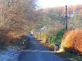
. Fala Hall Burn rises in the moor to the south of Fala Flow and forms the boundary between Fala and Soutra parishes. The streams eventually run into the Cakemuir Burn above Costerton. Due to its location south of the Soutra snow gate, the village, particularly Fala Dam, can often get cut off from the outside world during heavy snowfalls, with residents known to be snowed in for several days.
Highways
In 1834 a road (today the A68), with a still extant Toll House at Fala, was constructed between Edinburgh and LauderLauder
The Royal Burgh of Lauder is a town in the Scottish Borders 27 miles south east of Edinburgh. It is also a royal burgh in the county of Berwickshire. It lies on the edge of the Lammermuir Hills, on the Southern Upland Way.-Medieval history:...
and it bisects the parish, marking off the cultivated lands to the east from the pastures to the west.
To the west of this highway can be traced the King's Road, which is said to have been made by King Malcolm IV to cross the Lammermuirs
Lammermuir Hills
The Lammermuir Hills, usually simply called the Lammermuirs , in southern Scotland, form a natural boundary between Lothian and the Scottish Borders....
to Lauderdale
Lauderdale
Lauderdale, denoting "dale of the river Leader", is the dale and region around that river in south-eastern Scotland.It can also refer to:-People:*Earls of Lauderdale*Lord Lauderdale, member of The Cabal of Charles II of England-Place names:Australia...
. Dere Street
Dere Street
Dere Street or Deere Street, was a Roman road between Eboracum and Veluniate, in what is now Scotland. It still exists in the form of the route of many major roads, including the A1 and A68 just north of Corbridge.Its name corresponds with the post Roman Anglo-Saxon kingdom of Deira, through...
, the Roman road, can be traced at various places on the hills towards Channelkirk to the south west of the A68.
Dam
For many years the best-known thing connected with the parish (according to Andrew Bain) was Fala Dam, which at one time had a railway spur to it to assist with construction.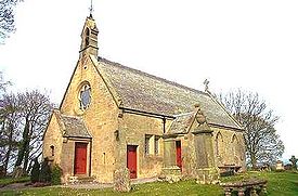
Church
In the ancient taxation of 1137, Fala KirkKirk
Kirk can mean "church" in general or the Church of Scotland in particular. Many place names and personal names are also derived from it.-Basic meaning and etymology:...
had to pay, as its proportion, the sum of six marks, and the Rectory
Rectory
A rectory is the residence, or former residence, of a rector, most often a Christian cleric, but in some cases an academic rector or other person with that title...
of Fala was, like the other churches in Midlothian during the tenth and eleventh centuries, under the diocese of St. Cuthbert. The patronage of Fala, from that time until the 19th century lay with the Lord of the Manor
Lord of the Manor
The Lordship of a Manor is recognised today in England and Wales as a form of property and one of three elements of a manor that may exist separately or be combined and may be held in moieties...
or principal laird of the parish. In ancient times there were some Trinity Friars who had charge of a small hospital in connection with Fala Church (not to be confused with Soutra Aisle
Soutra Aisle
Soutra Aisle, just within the Scottish Borders, not far from Fala, is the remains of the House of the Holy Trinity, a church that was part of a complex comprising a hospital and a friary...
), as is evidenced by an entry in the Exchequer Rolls of Scotland in 1365. In Forbes's Book on Tithes, he mentions that the Order of the Trinity Friars was appointed and confirmed by Pope Innocent III
Pope Innocent III
Pope Innocent III was Pope from 8 January 1198 until his death. His birth name was Lotario dei Conti di Segni, sometimes anglicised to Lothar of Segni....
in 1200. In the time of King James V
James V of Scotland
James V was King of Scots from 9 September 1513 until his death, which followed the Scottish defeat at the Battle of Solway Moss...
the Rectory of Fala was taxed at £6, 13s. 4p.
The present parish church is a long 18th century building, with a modest rebuild to an economically Gothicized design by David Bryce
David Bryce
David Bryce FRSE FRIBA RSA was a Scottish architect. Born in Edinburgh, he was educated at the Royal High School and joined the office of architect William Burn in 1825, aged 22. By 1841, Bryce had risen to be Burn's partner...
in 1863. The Manse
Manse
A manse is a house inhabited by, or formerly inhabited by, a minister, usually used in the context of a Presbyterian, Methodist, Baptist or United Church...
of 1792 also survives.
The school and connected school house of circa 1840 was extended in 1875. However, due to a declining roll, the primary school eventually closed but the building remains and is now used as a private nursery for children aged 6 months to 5 years. Children of primary school age are accommodated at the nearby Humbie Primary School. Secondary school education is provided at Dalkeith High School.