
Etropole Peak
Encyclopedia
Melnik Ridge
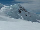
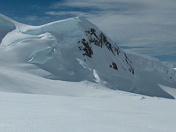
Melnik Ridge is a narrow ridge rising to 696 m in eastern Livingston Island in the South Shetland Islands, Antarctica bounded by Kaliakra Glacier to the north and west, and Struma Glacier to the south, and linked to Bowles Ridge by the 575 m high Yankov Gap...
, Livingston Island and is named after the town of Etropole
Etropole
Etropole is a town in western Bulgaria, part of Sofia Province. It is located close to the northern slopes of the Balkan Mountains in the valley of the Malki Iskar from Sofia.-History:...
in Central Bulgaria
Bulgaria
Bulgaria , officially the Republic of Bulgaria , is a parliamentary democracy within a unitary constitutional republic in Southeast Europe. The country borders Romania to the north, Serbia and Macedonia to the west, Greece and Turkey to the south, as well as the Black Sea to the east...
.
Maps
- L.L. Ivanov et al. Antarctica: Livingston Island and Greenwich Island, South Shetland Islands. Scale 1:100000 topographic map. Sofia: Antarctic Place-names Commission of Bulgaria, 2005.
- L.L. Ivanov. Antarctica: Livingston Island and Greenwich, Robert, Snow and Smith Islands. Scale 1:120000 topographic map. Troyan: Manfred Wörner Foundation, 2009.
Location
The peak is located at 62°36′07"S 60°08′25"W which is 660 m east of Melnik PeakMelnik Peak
Melnik Peak is the 696 m summit of Melnik Ridge in eastern Livingston Island, South Shetland Islands in Antarctica. Surmounting Kaliakra Glacier to the north and west, and Struma Glacier to the southeast...
, 620 m west of Sliven Peak
Sliven Peak
Sliven Peak rises to 530 m in the east extremity of Melnik Ridge, Livingston Island in the South Shetland Islands, Antarctica...
and 1.92 km northwest of Atanasoff Nunatak
Atanasoff Nunatak
Atanasoff Nunatak is a nunatak, a sharp peak rising to 523 m in the east extremity of Bowles Ridge, Livingston Island, Antarctica. The peak sumounts Huron Glacier to the south and east, and Struma Glacier to the north...
(Bulgarian mapping in 2005 and 2009 from the Tangra 2004/05
Tangra 2004/05
The Tangra 2004/05 Expedition was commissioned by the Antarctic Place-names Commission at the Ministry of Foreign Affairs of Bulgaria, managed by the Manfred Wörner Foundation, and supported by the Bulgarian Antarctic Institute, the Institute of Mathematics and Informatics at the Bulgarian Academy...
topographic survey).