
Ellis Beach, Queensland
Encyclopedia
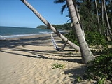
Ellis Beach is a locality in Tropical North Queensland
, Australia
. It lies on the Coral Sea
. At the 2006 census
, Ellis Beach had a population of 30.
The five-kilometre strip of Ellis Beach is located 20 km north of Cairns on the Captain Cook Highway
between Cairns
and Port Douglas
, within the Cairns Region local government area
.
Ellis Beach is also home to the Ellis Beach Surf Lifesaving Club which regularly hosts competitions and events. From November to May, a stinger net patrolled by the club helps protect swimmers from marine "stingers" (jellyfish species of Chironex
and Irukandji
) which inhabit the waters during those months.
Ellis Beach featured in the fourth season of the Amazing Race
.
Before World War II
the area was unnamed (in English) and had no houses. It was only during the war years that it became known as Ellis Beach and this fits with all other records. There are a number of mango trees at Ellis Beach, which it is believed were tended by Mr Ellis. After the construction of the Cook Highway through the area the authorities decided to plant many varieties of trees along each side of the roadway. This was done where the terrain permitted. Mangoes were particularly suitable for this purpose and many of the original trees survive along with other flowering trees. Those along the stretch of road at Ellis Beach would no doubt owe their existence to Dick Ellis. In other areas drought and fire have taken their toll but some still exist.
Far North Queensland
Far North Queensland, or FNQ, is the northernmost part of the Australian state of Queensland. The region, which contains a large section of the Tropical North Queensland area, stretches from the city of Cairns north to the Torres Strait...
, Australia
Australia
Australia , officially the Commonwealth of Australia, is a country in the Southern Hemisphere comprising the mainland of the Australian continent, the island of Tasmania, and numerous smaller islands in the Indian and Pacific Oceans. It is the world's sixth-largest country by total area...
. It lies on the Coral Sea
Coral Sea
The Coral Sea is a marginal sea off the northeast coast of Australia. It is bounded in the west by the east coast of Queensland, thereby including the Great Barrier Reef, in the east by Vanuatu and by New Caledonia, and in the north approximately by the southern extremity of the Solomon Islands...
. At the 2006 census
Census in Australia
The Australian census is administered once every five years by the Australian Bureau of Statistics. The most recent census was conducted on 9 August 2011; the next will be conducted in 2016. Prior to the introduction of regular censuses in 1961, they had also been run in 1901, 1911, 1921, 1933,...
, Ellis Beach had a population of 30.
The five-kilometre strip of Ellis Beach is located 20 km north of Cairns on the Captain Cook Highway
Captain Cook Highway
Captain Cook Highway is a short Queensland highway that starts in Cairns and ends in Mossman, where it joins Mossman-Daintree Road, which continues to Daintree.Captain Cook Highway is used by many tourists to travel to Port Douglas north of Cairns...
between Cairns
Cairns, Queensland
Cairns is a regional city in Far North Queensland, Australia, founded 1876. The city was named after William Wellington Cairns, then-current Governor of Queensland. It was formed to serve miners heading for the Hodgkinson River goldfield, but experienced a decline when an easier route was...
and Port Douglas
Port Douglas, Queensland
Port Douglas is a town in Far North Queensland, Australia, approximately north of Cairns. Its permanent population was 948 residents in 2006. The town's population can often double, however, with the influx of tourists during the peak tourism season May–September. The town is named in honour of...
, within the Cairns Region local government area
Local Government Areas of Queensland
This is a list of local government areas in Queensland, sorted by region. For the history and responsibilities of local government in that state, see Local government in Queensland.-LGAs sorted by region:...
.
Ellis Beach is also home to the Ellis Beach Surf Lifesaving Club which regularly hosts competitions and events. From November to May, a stinger net patrolled by the club helps protect swimmers from marine "stingers" (jellyfish species of Chironex
Chironex
Chironex is a genus of box jellyfish in the Chirodropidae family. Traditionally, only a single species, C. fleckeri, was recognized in this genus, but in 2009 a second species, C.yamaguchii, was described. Their stings are highly venomous, and both species have caused human fatalities...
and Irukandji
Irukandji jellyfish
Irukandji jellyfish are tiny and extremely venomous jellyfish that inhabit marine waters of Australia and which are able to fire their stingers into their victim, causing symptoms collectively known as Irukandji syndrome. Its size is roughly no larger than a cubic centimetre...
) which inhabit the waters during those months.
Ellis Beach featured in the fourth season of the Amazing Race
The Amazing Race 4
The Amazing Race 4 is the fourth installment of the reality television show on US television The Amazing Race. The Amazing Race 4 featured 12 teams of two, with a pre-existing relationship, in a race around the world...
.
History of Ellis Beach
While the history of Ellis Beach is somewhat vague, the Cairns Historical Society's records show that it was named after Dick Ellis, who at the time resided at this beach. He was a shot firer for the Queensland Department of Main Roads - presumably at the time the Cook Highway was constructed in the early 1930s. He lost a hand and the state government constructed a house for him at the beach now known as Ellis Beach on the spot where the café now stands. This was about 1940 and Dick Ellis died in 1960.Before World War II
World War II
World War II, or the Second World War , was a global conflict lasting from 1939 to 1945, involving most of the world's nations—including all of the great powers—eventually forming two opposing military alliances: the Allies and the Axis...
the area was unnamed (in English) and had no houses. It was only during the war years that it became known as Ellis Beach and this fits with all other records. There are a number of mango trees at Ellis Beach, which it is believed were tended by Mr Ellis. After the construction of the Cook Highway through the area the authorities decided to plant many varieties of trees along each side of the roadway. This was done where the terrain permitted. Mangoes were particularly suitable for this purpose and many of the original trees survive along with other flowering trees. Those along the stretch of road at Ellis Beach would no doubt owe their existence to Dick Ellis. In other areas drought and fire have taken their toll but some still exist.