

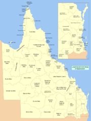
Local Government Areas of Queensland
Encyclopedia
Queensland
Queensland is a state of Australia, occupying the north-eastern section of the mainland continent. It is bordered by the Northern Territory, South Australia and New South Wales to the west, south-west and south respectively. To the east, Queensland is bordered by the Coral Sea and Pacific Ocean...
, sorted by region. For the history and responsibilities of local government in that state, see Local government in Queensland
Local government in Queensland
Local government in the Australian state of Queensland describes the institutions and processes by which towns and districts can manage their own affairs to the extent permitted by the Local Government Act 1993-2007. Queensland is divided into 73 local government areas which may be called Cities,...
.
LGAs sorted by region
| Name |
Council seat |
Region |
Year Estab. |
Area (km²) |
Pop'n (2006) |
Notes |
Map |
|---|---|---|---|---|---|---|---|
| Brisbane Brisbane central business district The Brisbane central business district , sometimes referred to as the city, is a suburb of Brisbane, Queensland, Australia and is located on a point on the northern bank of the Brisbane River. The triangular shaped area is bounded by the Brisbane River to the east, south and west... |
South East Queensland South East Queensland South East Queensland is a region of the state of Queensland in Australia, which contains approximately two-thirds of the state population... |
1924 | 1,367 | Capital city Capital City Capital City was a television show produced by Euston Films which focused on the lives of investment bankers in London living and working on the corporate trading floor for the fictional international bank Shane-Longman.... of Queensland Queensland Queensland is a state of Australia, occupying the north-eastern section of the mainland continent. It is bordered by the Northern Territory, South Australia and New South Wales to the west, south-west and south respectively. To the east, Queensland is bordered by the Coral Sea and Pacific Ocean... Administers the central portion of the South East Queensland South East Queensland South East Queensland is a region of the state of Queensland in Australia, which contains approximately two-thirds of the state population... agglomeration Amalgamation of cities of Brisbane and South Brisbane, towns of Hamilton, Ithaca Town of Ithaca Ithaca was a local government area of Queensland, located in western Brisbane. The Division of Ithaca was first proclaimed in 1879, and originally covered an area that stretched from Windsor, Kelvin Grove and Milton in the east, through to The Gap and beyond the Enoggera Dam in the west... , Sandgate, Toowong, Windsor and Wynnum, and shires of Balmoral, Belmont, Coorparoo, Enoggera, Kedron, Moggill, Sherwood, Stephens Shire of Stephens The Shire of Stephens was a Local Government Area in the inner southern suburbs of Brisbane, Queensland. The shire, administered from Annerley, covered an area of , and existed as a local government entity from 1886 until 1925, when it was amalgamated into the City of Brisbane under the City of... , Taringa, Tingalpa Shire of Tingalpa The Shire of Tingalpa was a Local Government Area in the south-eastern suburbs of Brisbane, Queensland. The shire, administered from Mount Cotton, covered an area of , and existed as a local government entity from 1879 until 1949.-History:... , Toombul and Yeerongpilly Shire of Yeerongpilly The Shire of Yeerongpilly was a Local Government Area in the southern suburbs of Brisbane, Queensland. The shire, administered from Rocklea, covered an area of , and existed as a local government entity from 1879 until 1925, when it was split up following the creation of the City of Brisbane under... . |
 |
||
| Nerang Nerang, Queensland Nerang is a suburb on the Gold Coast in Queensland, Australia, that lies upon the Nerang River. At the 2006 Census, Nerang had a population of 16,066.... |
South East Queensland South East Queensland South East Queensland is a region of the state of Queensland in Australia, which contains approximately two-thirds of the state population... |
1948 | 1,358 |  |
|||
| Ipswich Ipswich, Queensland Ipswich is a city in South-East Queensland, Australia. Situated along the Bremer River Valley approximately 40 kilometres away from the state's capital Brisbane. The suburb by the same name forms the city's Central Business District and administrative centre... |
South East Queensland South East Queensland South East Queensland is a region of the state of Queensland in Australia, which contains approximately two-thirds of the state population... |
1860 | 1,089 |  |
|||
| Gatton Gatton, Queensland Gatton is a town and the administrative centre of the Lockyer Valley Local Government Area situated in the Lockyer Valley of South East Queensland, Australia. At the 2006 census, Gatton had a population of 5,295.... |
South East Queensland South East Queensland South East Queensland is a region of the state of Queensland in Australia, which contains approximately two-thirds of the state population... |
2008 | 2,273 | ||||
| Logan Central Logan Central, Queensland Logan Central is a suburb of Logan City, Queensland, Australia.Once forming part of Woodridge, Logan Central is the official central business district of Logan City and is a major activity centre, with many shops and local businesses operating in the area, mostly along the Wembley Road corridor... |
South East Queensland South East Queensland South East Queensland is a region of the state of Queensland in Australia, which contains approximately two-thirds of the state population... |
1978 | 913 |  |
|||
| Strathpine Strathpine, Queensland Strathpine is a suburb north of Brisbane, Queensland, Australia. Its Local Government Area is the Moreton Bay Region. It is home to the Pine Rivers District offices of the Moreton Bay Region as well as many businesses. The area contains a medium-sized Westfield shopping centre... |
South East Queensland South East Queensland South East Queensland is a region of the state of Queensland in Australia, which contains approximately two-thirds of the state population... |
2008 | 2,011 | Amalgamation of City of Redcliffe City of Redcliffe City of Redcliffe is a defunct Local Government Area in South East Queensland, Australia. It is in the northern part of the County of Stanley. The council covers the suburbs of Clontarf, Kippa-Ring, Margate, Redcliffe, Rothwell, Scarborough and Woody Point – a total area of 38.1 km² with a... and the shires of Pine Rivers and Caboolture Shire of Caboolture The Shire of Caboolture was a Local Government Area located in the Australian state of Queensland on the northern urban fringe of the capital, Brisbane, and south of the Sunshine Coast... . |
|||
| Cleveland Cleveland, Queensland Cleveland is a suburb located approximately east-south-east of Brisbane, the capital of the Australian state of Queensland, and is the council seat for the Redland City local government area... |
South East Queensland South East Queensland South East Queensland is a region of the state of Queensland in Australia, which contains approximately two-thirds of the state population... |
1949 | 537 | ||||
| Beaudesert Beaudesert, Queensland Beaudesert is a town located on the Mount Lindesay Highway, some 64 km south of Brisbane. It is possibly named after Beau Desert Park, the property of Charles Henry Alexander Paget, 6th Marquess of Anglesey in Staffordshire, England... |
South East Queensland South East Queensland South East Queensland is a region of the state of Queensland in Australia, which contains approximately two-thirds of the state population... |
2008 | 4,256 | ||||
| Esk Esk, Queensland Esk is a town in the West Moreton region of South East Queensland, approximately 90 km northwest of Ipswich on the Brisbane Valley Highway. It was named after the River Esk in Scotland and England. It is the administrative centre of the Somerset Region... |
South East Queensland South East Queensland South East Queensland is a region of the state of Queensland in Australia, which contains approximately two-thirds of the state population... |
2008 | 5,379 |  |
|||
| Nambour Nambour, Queensland The area now known as Nambour, was first settled in 1870. The town was then called Petrie's Creek. In 1890 the Maroochy Divisional Board was established... |
South East Queensland South East Queensland South East Queensland is a region of the state of Queensland in Australia, which contains approximately two-thirds of the state population... |
3,126 |  |
||||
| Biloela Biloela, Queensland Biloela is a rural town in Central Queensland, Australia. It is situated inland from the port city of Gladstone at the junction of the Burnett and Dawson highways... |
Wide Bay-Burnett | 1879 | 28,577 | ||||
| Bundaberg | Wide Bay-Burnett | 2008 | 6,451 | 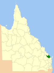 |
|||
| Cherbourg Cherbourg, Queensland Cherbourg is a town in the South Burnett region of Queensland, Australia. It is located off the Bunya Highway approximately north-west of Brisbane and from the town of Murgon. It is situated very close to the dam wall of Bjelke-Petersen Dam. Attractions in Cherbourg include the 'Bert Button... |
Wide Bay-Burnett | 1986 | 32 | ||||
| Hervey Bay | Wide Bay-Burnett | 2008 | 7,125 | ||||
| Gympie Gympie Gympie may refer to:* Gympie, a city in Queensland, Australia** Gympie Airport** Electoral district of Gympie** Gympie Region, its local government authority* Gympie Gympie , a stinging plant... |
Wide Bay-Burnett | 2008 | 6,898 | 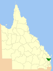 |
|||
| Gayndah Gayndah, Queensland Gayndah is a town located on the Burnett River in Queensland, Australia. It is north of the state capital, Brisbane, and west of the regional city of Maryborough. The Burnett Highway passes through the town. At the 2006 census, Gayndah had a population of 1,745.-History:Exploration of the... |
Wide Bay-Burnett | 2008 | 19,708 | ||||
| Kingaroy | Wide Bay-Burnett | 2008 | 8,399 | 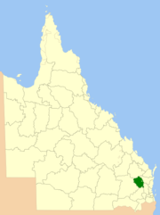 |
|||
| Goondiwindi | Darling Downs | 2008 | 19,294 | 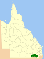 |
|||
| Warwick Warwick, Queensland Warwick is a town in Queensland, Australia, lying south-west of Brisbane. It is the administrative centre of the Southern Downs Local Government Area. In 2006 the town of Warwick had a population of 12,562.... |
Darling Downs | 2008 | 7,120 | 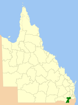 |
|||
| Toowoomba | Darling Downs | 2008 | 12,973 | 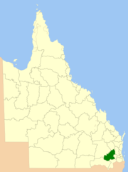 |
|||
| Dalby Dalby, Queensland Dalby is a town in the Darling Downs region of Queensland, Australia, and is located approximately west of the state capital, Brisbane, at the junction of the Warrego, Moonie and Bunya Highways. Dalby is the administrative centre of the Western Downs Region and the centre of Australia's richest... |
Darling Downs | 2008 | 38,039 | Renamed from Dalby in August 2009 |  |
||
| Emerald Emerald, Queensland Emerald is a town located in the Central Highlands district of Central Queensland, Australia. At the 2006 census, Emerald had a population of 10,999. The town is the business centre for the Central Highlands Regional Council.... |
Central Queensland Central Queensland Central Queensland is an ambiguous geographical division of Queensland that centres on the eastern coast, around the Tropic of Capricorn. Its major regional centre is Rockhampton and the Capricorn Coast and the area extends west to the Central Highlands at Emerald, north to the Mackay Regional... |
2008 | 59,884 | 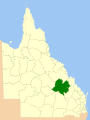 |
|||
| Gladstone Gladstone, Queensland - Education :Gladstone has several primary schools, three high schools, and one university campus, Central Queensland University. It is also home to CQIT Gladstone Campus.- Recreation :... |
Central Queensland Central Queensland Central Queensland is an ambiguous geographical division of Queensland that centres on the eastern coast, around the Tropic of Capricorn. Its major regional centre is Rockhampton and the Capricorn Coast and the area extends west to the Central Highlands at Emerald, north to the Mackay Regional... |
2008 | 10,488 | 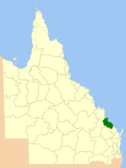 |
|||
| Clermont Clermont, Queensland Clermont is an agricultural town in the Isaac Region, Queensland, Australia. It is 274 km south-west of Mackay on the junction of the Gregory and Peak Downs highways... |
Central Queensland Central Queensland Central Queensland is an ambiguous geographical division of Queensland that centres on the eastern coast, around the Tropic of Capricorn. Its major regional centre is Rockhampton and the Capricorn Coast and the area extends west to the Central Highlands at Emerald, north to the Mackay Regional... |
2008 | 58,862 |  |
|||
| Mackay Mackay, Queensland Mackay is a city on the eastern coast of Queensland, Australia, about north of Brisbane, on the Pioneer River. Mackay is nicknamed the sugar capital of Australia because its region produces more than a third of Australia's cane sugar.... |
Central Queensland Central Queensland Central Queensland is an ambiguous geographical division of Queensland that centres on the eastern coast, around the Tropic of Capricorn. Its major regional centre is Rockhampton and the Capricorn Coast and the area extends west to the Central Highlands at Emerald, north to the Mackay Regional... |
2008 | 7,621 | ||||
| Rockhampton Rockhampton Rockhampton can refer to:* Rockhampton, Queensland is a city in Queensland, Australia* Rockhampton City, Queensland, a suburb of Rockhampton, Queensland* Electoral district of Rockhampton, Queensland, Australia... |
Central Queensland Central Queensland Central Queensland is an ambiguous geographical division of Queensland that centres on the eastern coast, around the Tropic of Capricorn. Its major regional centre is Rockhampton and the Capricorn Coast and the area extends west to the Central Highlands at Emerald, north to the Mackay Regional... |
2008 | 18,361 | ||||
| Woorabinda Woorabinda, Queensland Woorabinda is an Aboriginal community in central Queensland, Australia, inland of Rockhampton. At the 2006 census, Woorabinda had a population of 851.Woorabinda was first established in 1927 as a replacement for the Aboriginal camp at Taroom... |
Central Queensland Central Queensland Central Queensland is an ambiguous geographical division of Queensland that centres on the eastern coast, around the Tropic of Capricorn. Its major regional centre is Rockhampton and the Capricorn Coast and the area extends west to the Central Highlands at Emerald, north to the Mackay Regional... |
1986 | 391 | ||||
| Ayr Ayr, Queensland Ayr is a town in Queensland, Australia near the delta of the Burdekin River, named after the Scottish town of Ayr by the settlers from the United Kingdom... |
North Queensland North Queensland North Queensland or the Northern Region is the northern part of the state of Queensland in Australia. Queensland is a massive state, larger than most countries, and the tropical northern part of it has been historically remote and undeveloped, resulting in a distinctive regional character and... |
1888 | 5,052 | ||||
| Charters Towers Charters Towers, Queensland Charters Towers is a city in northern Queensland, Australia. It is located 137 kilometres inland from Townsville on the Flinders Highway. In 2006 the population was 7,979 people, some 450 fewer than in the 2001 census. During the last quarter of the 19th century the town boomed as the rich gold... |
North Queensland North Queensland North Queensland or the Northern Region is the northern part of the state of Queensland in Australia. Queensland is a massive state, larger than most countries, and the tropical northern part of it has been historically remote and undeveloped, resulting in a distinctive regional character and... |
2008 | 68,388 | ||||
| Ingham Ingham, Queensland Ingham is a town in the Great Green Way region of North Queensland, Australia. The town was founded in 1864, gazetted a shire in 1879, and is the service centre for many sugarcane plantations, pioneered in the 1870s by William Ingham, for whom the town is named... |
North Queensland North Queensland North Queensland or the Northern Region is the northern part of the state of Queensland in Australia. Queensland is a massive state, larger than most countries, and the tropical northern part of it has been historically remote and undeveloped, resulting in a distinctive regional character and... |
1879 | 2,811 | ||||
| Palm Island Palm Island, Queensland Palm Island is an Aboriginal community located on Great Palm Island, also called by the Aboriginal name "Bwgcolman", an island on the Great Barrier Reef in North Queensland, Australia The settlement is also known by a variety of other names including "the Mission", Palm Island Settlement or Palm... |
North Queensland North Queensland North Queensland or the Northern Region is the northern part of the state of Queensland in Australia. Queensland is a massive state, larger than most countries, and the tropical northern part of it has been historically remote and undeveloped, resulting in a distinctive regional character and... |
1986 | 71 | ||||
| Townsville | North Queensland North Queensland North Queensland or the Northern Region is the northern part of the state of Queensland in Australia. Queensland is a massive state, larger than most countries, and the tropical northern part of it has been historically remote and undeveloped, resulting in a distinctive regional character and... |
2008 | 3,733 | 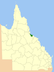 |
|||
| Bowen Bowen, Queensland Bowen is a town on the eastern coast of Queensland, Australia. At the 2006 census, Bowen had a population of 7,484.-Geography:Bowen is located on the north-east coast of Australia, at exactly twenty degrees south of the equator. In fact, the twentieth parallel crosses the main street... |
North Queensland North Queensland North Queensland or the Northern Region is the northern part of the state of Queensland in Australia. Queensland is a massive state, larger than most countries, and the tropical northern part of it has been historically remote and undeveloped, resulting in a distinctive regional character and... |
2008 | 23,856 | 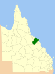 |
|||
| Aurukun Aurukun, Queensland Aurukun is an Indigenous community, situated approximately south of Weipa in far North Queensland, Australia. The town faces west to the Gulf of Carpentaria, and during the wet season, roads are impassable.... |
Far North Queensland Far North Queensland Far North Queensland, or FNQ, is the northernmost part of the Australian state of Queensland. The region, which contains a large section of the Tropical North Queensland area, stretches from the city of Cairns north to the Torres Strait... |
1978 | 7,375 | ||||
| Cairns | Far North Queensland Far North Queensland Far North Queensland, or FNQ, is the northernmost part of the Australian state of Queensland. The region, which contains a large section of the Tropical North Queensland area, stretches from the city of Cairns north to the Torres Strait... |
2008 | 4,128 | ||||
| Innisfail Innisfail, Queensland Innisfail is a town located in the far north of the state of Queensland, Australia. It is the major township of the Cassowary Coast and is well renowned for its sugar and banana industries, as well as for being one of Australia's wettest towns... |
Far North Queensland Far North Queensland Far North Queensland, or FNQ, is the northernmost part of the Australian state of Queensland. The region, which contains a large section of the Tropical North Queensland area, stretches from the city of Cairns north to the Torres Strait... |
2008 | 4,701 |  |
|||
| Cooktown Cooktown, Queensland Cooktown is a small town located at the mouth of the Endeavour River, on Cape York Peninsula in Far North Queensland where James Cook beached his ship, the Endeavour, for repairs in 1770. At the 2006 census, Cooktown had a population of 1,336... |
Far North Queensland Far North Queensland Far North Queensland, or FNQ, is the northernmost part of the Australian state of Queensland. The region, which contains a large section of the Tropical North Queensland area, stretches from the city of Cairns north to the Torres Strait... |
1919 | 106,188 | ||||
| Hopevale Hopevale, Queensland Hopevale, , Queensland, Australia is an Aboriginal community on Cape York Peninsula about 46 km northwest of Cooktown by road, and about 10 km off the Battlecamp Road that leads to Lakefield National Park and Laura... |
Far North Queensland Far North Queensland Far North Queensland, or FNQ, is the northernmost part of the Australian state of Queensland. The region, which contains a large section of the Tropical North Queensland area, stretches from the city of Cairns north to the Torres Strait... |
1986 | 1,118 | ||||
| Kowanyama Kowanyama, Queensland Kowanyama is a town on the Gulf of Carpentaria side of Cape York Peninsula in Far North Queensland, Australia.At the 2006 census, Kowanyama had a population of 1,017.... |
Far North Queensland Far North Queensland Far North Queensland, or FNQ, is the northernmost part of the Australian state of Queensland. The region, which contains a large section of the Tropical North Queensland area, stretches from the city of Cairns north to the Torres Strait... |
1987 | 2,576 | ||||
| Lockhart River Lockhart River, Queensland Lockhart River is a coastal Aboriginal community situated on the eastern coast of Cape York Peninsula in Queensland, Australia. The population consists mostly of Aboriginal and Torres Strait Islanders, whose ancestors were forcibly moved to the area beginning in 1924... |
Far North Queensland Far North Queensland Far North Queensland, or FNQ, is the northernmost part of the Australian state of Queensland. The region, which contains a large section of the Tropical North Queensland area, stretches from the city of Cairns north to the Torres Strait... |
1987 | 3,545 | ||||
| Mapoon | Far North Queensland Far North Queensland Far North Queensland, or FNQ, is the northernmost part of the Australian state of Queensland. The region, which contains a large section of the Tropical North Queensland area, stretches from the city of Cairns north to the Torres Strait... |
2002 | 530 | ||||
| Napranum Napranum, Queensland Napranum is a small community on the Cape York Peninsula in remote Far North Queensland. Formerly known as Weipa South, Napranum was established in 1898 by Moravian missionaries on behalf of the Presbyterian church. Napranum is now governed by a local Aboriginal council... |
Far North Queensland Far North Queensland Far North Queensland, or FNQ, is the northernmost part of the Australian state of Queensland. The region, which contains a large section of the Tropical North Queensland area, stretches from the city of Cairns north to the Torres Strait... |
1989 | 1,995 | ||||
| Bamaga Bamaga, Queensland -Language:The community languages of Bamaga are Kalaw Kawaw Ya, Brokan , and English, particularly for education and government business.-Industry:... |
Far North Queensland Far North Queensland Far North Queensland, or FNQ, is the northernmost part of the Australian state of Queensland. The region, which contains a large section of the Tropical North Queensland area, stretches from the city of Cairns north to the Torres Strait... |
2008 | 1,030 | ||||
| Pormpuraaw Pormpuraaw, Queensland Pormpuraaw is an Aboriginal community situated on the west coast of Cape York Peninsula approximately half way between Karumba and Weipa on the Edward River. It is by road from Cairns. Pormpuraaw currently has a 2-man police station... |
Far North Queensland Far North Queensland Far North Queensland, or FNQ, is the northernmost part of the Australian state of Queensland. The region, which contains a large section of the Tropical North Queensland area, stretches from the city of Cairns north to the Torres Strait... |
1987 | 4,433 | ||||
| Malanda Malanda, Queensland Malanda is a medium-sized town on the Atherton Tableland in Far North Queensland, Australia. It is located from Cairns and above sea level. Malanda first developed in the 1880s when the discovery of tin and copper at Herberton saw a steady stream of miners and engineers moving over the mountains... |
Far North Queensland Far North Queensland Far North Queensland, or FNQ, is the northernmost part of the Australian state of Queensland. The region, which contains a large section of the Tropical North Queensland area, stretches from the city of Cairns north to the Torres Strait... |
2008 | 64,999 |  |
|||
| Thursday Island | Far North Queensland Far North Queensland Far North Queensland, or FNQ, is the northernmost part of the Australian state of Queensland. The region, which contains a large section of the Tropical North Queensland area, stretches from the city of Cairns north to the Torres Strait... |
1974 | 886 | ||||
| Thursday Island | Far North Queensland Far North Queensland Far North Queensland, or FNQ, is the northernmost part of the Australian state of Queensland. The region, which contains a large section of the Tropical North Queensland area, stretches from the city of Cairns north to the Torres Strait... |
2008 | 489 | ||||
| Weipa Weipa, Queensland Weipa is the largest town on the Gulf of Carpentaria coast of the Cape York Peninsula in Queensland, Australia. At the 2006 census, Weipa had a population of 2,830; the largest community on Cape York Peninsula. It exists because of the enormous bauxite deposits along the coast... |
Far North Queensland Far North Queensland Far North Queensland, or FNQ, is the northernmost part of the Australian state of Queensland. The region, which contains a large section of the Tropical North Queensland area, stretches from the city of Cairns north to the Torres Strait... |
1963 | Administered under own Act by Rio Tinto Alcan | ||||
| Wujal Wujal | Far North Queensland Far North Queensland Far North Queensland, or FNQ, is the northernmost part of the Australian state of Queensland. The region, which contains a large section of the Tropical North Queensland area, stretches from the city of Cairns north to the Torres Strait... |
1987 | 11 | ||||
| Yarrabah Yarrabah, Queensland Yarrabah is an Aboriginal community situated approximately by road from Cairns CBD on Cape Grafton. It is much closer by direct-line distance but is separated from Cairns by the Murray Prior Range and an inlet of the Coral Sea. At the 2006 census, Yarrabah had a population of 2,371... |
Far North Queensland Far North Queensland Far North Queensland, or FNQ, is the northernmost part of the Australian state of Queensland. The region, which contains a large section of the Tropical North Queensland area, stretches from the city of Cairns north to the Torres Strait... |
1986 | 158 | ||||
| Burketown Burketown, Queensland - Morning glory cloud :From the months of August to November, a rare meteorological phenomenon known as "Morning Glory" - long, tubular clouds, some up to 1000 km in length - is often observed in the skies above Burketown..... |
North West | 1885 | 40,126 | ||||
| Normanton Normanton, Queensland -External links:****... |
North West | 1883 | 64,373 | ||||
| Cloncurry Cloncurry, Queensland -Notable residents:*Writer Alexis Wright grew up in Cloncurry.*Association Footballer Kasey Wehrman was born in Cloncurry . He went on to play domestically and in Scandinavia. His achievements include winning a NSL Championship in 1996-1997 with the Brisbane Strikers and being capped several times... |
North West | 1884 | 48,113 | ||||
| Croydon Croydon, Queensland Croydon is a town in Queensland, Australia. At the 2006 census, the town and surrounding area had a population of 255.-History:The historic goldrush town of Croydon is located in the heart of the Gulf Savannah, 562 km west of Cairns. Croydon was a large pastoral holding covering an area of... |
North West | 1887 | 29,578 | ||||
| Doomadgee Doomadgee, Queensland Doomadgee Aboriginal Mission, originally known as Dumaji, was located on Bayley Point on the Gulf of Carpentaria. In 1936 after being destroyed by a cyclone the community was relocated to Nicholson River... |
North West | 1987 | 1,862 | ||||
| Georgetown Georgetown, Queensland Georgetown is a town on the Etheridge River in Far North Queensland, Australia. The Gulf Developmental Road passes through the town, linking Cairns - 412 km to the east - and Normanton - 301 km to the west... |
North West | 1882 | 39,332 | ||||
| Hughenden Hughenden, Queensland Hughenden is a town in Queensland, Australia situated on the banks of the Flinders River. It was named after Hughenden Manor, the home of former British Prime Minister Benjamin Disraeli. At the 2006 census, Hughenden had a population of 1,154.-History:... |
North West | 1882 | 41,538 | ||||
| Julia Creek Julia Creek, Queensland Julia Creek is a town in mid northern Queensland, located on the Overlander's Way, the main road between Mount Isa and Townsville. It is west of Townsville, and is located 123 m above sea level. At the 2006 census, Julia Creek had a population of 368.... |
North West | 1891 | 40,880 | ||||
| Gununa Mornington Island Mornington Island is the northern most of 22 islands that form the Wellesley Islands group. The island is located in the Gulf of Carpentaria at and is part of the Gulf Country region in the Australian state of Queensland. The Manowar and Rocky Islands Important Bird Area lies about 40 km to... |
North West | 1978 | 1,232 | ||||
| Mount Isa | North West | 1914 | 43,349 | ||||
| Richmond Richmond, Queensland Richmond is a town in western Queensland, Australia. The town is located on the Flinders Highway, 498 km west of Townsville and 406 km east of Mount Isa. It is the administrative centre of the Richmond Shire. At the 2006 census, Richmond had a population of 554.The Flinders River forms... |
North West | 1910 | 26,602 | ||||
| Barcaldine Barcaldine, Queensland Barcaldine is a small town in Western Queensland, Australia, approximately by road west of the city of Rockhampton. The town is situated on Lagoon Creek, which flows into the Alice River approximately five kilometres south of the Barcaldine. This is the administrative centre of the Barcaldine... |
Central West | 2008 | 53,677 |  |
|||
| Jundah Jundah, Queensland Jundah is a town in far western Queensland, Australia. The administrative centre of the Barcoo Shire Local Government Area, the town is located on the Thomson River, west of the state capital, Brisbane. At the 2006 census, Jundah had a population of 93.... |
Central West | 1885 | 62,001 | ||||
| Blackall Blackall, Queensland -External links:*... |
Central West | 2008 | 30,451 |  |
|||
| Boulia Boulia, Queensland Boulia is a town in Central West Queensland, Australia. It is located approximately by road south of Mount Isa, and lies on the Burke River, which was named after the explorer Robert O'Hara Burke who passed through the area with the Burke and Wills expedition in 1860. The township was gazetted in... |
Central West | 1887 | 61,102 | ||||
| Bedourie Bedourie, Queensland Bedourie is a small town located in the Channel Country of western Queensland, Australia, lying on Eyre Creek. It is located 1600 kilometres west of the state capital, Brisbane, and 200 kilometres north of Birdsville. At the 2006 census, Bedourie and the surrounding area had a population of 142... |
Central West | 1879 | 94,823 | ||||
| Longreach | Central West | 2008 | 40,638 | 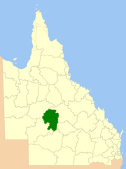 |
|||
| Winton Winton, Queensland -Qantas:Winton was one of the founding towns of the Australian airline Qantas. The first board meeting was held at the Winton Club on 10 February 1921.-Waltzing Matilda:... |
Central West | 1886 | 53,935 | ||||
| St George St George, Queensland St George is a town of approximately 2400 people in south-western Queensland, Australia. It is the administrative centre for the Shire of Balonne. It was named by Major Thomas Mitchell who crossed the Balonne River on St George's Day, 23 April 1846. At the 2006 census, St George had a population of... |
South West | 1883 | 31,150 | ||||
| Thargomindah Thargomindah, Queensland - External links:* * * *... |
South West | 1880 | 73,807 | ||||
| Roma Roma, Queensland Roma is a town in the western Darling Downs area of Queensland, Australia, by rail WNW of Brisbane. It is situated at the junction of the Warrego and Carnarvon highways... |
South West | 2008 | 58,830 | Renamed from Roma in June 2009 | |||
| Charleville Charleville, Queensland Charleville is a town in south western Queensland, Australia, 758 kilometres by road west of Brisbane . It is the largest town and administrative centre of the Murweh Shire, which covers an area of 43,905 square kilometres... |
South West | 1879 | 40,742 | ||||
| Cunnamulla Cunnamulla, Queensland Cunnamulla is a small town that lies on the Warrego River in south west Queensland, Australia, south of Charleville, and approximately west of the state capital, Brisbane.... |
South West | 1879 | 47,714 | ||||
| Quilpie Quilpie, Queensland -External links:* *... |
South West | 1930 | 67,633 |