
Eldorado Air Force Station
Encyclopedia
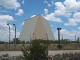
Eldorado Air Force Station located 35 miles south of San Angelo, Texas
and was one of the four unique AN/FPS-115 PAVE PAWS
, early-warning
phased-array radar systems. The 8th Space Warning Squadron
, 21st Space Wing
, Air Force Space Command
operated at Eldorado
Air Force Station.
As the likelihood of sea-based missile attacks from the Gulf of Mexico
decreased, and the low probability of missile attacks from the South, the United States Air Force
decided to close southern-facing PAVE PAWS
sites at Robins Air Force Base
and Eldorado, Texas
. Two radar faces, one each from Robins and Eldorado, were moved to Clear Air Force Station
, Alaska
as part of the BMEWS upgrade in 1998.
, 35 miles north, and was part of the NORAD at Cheyenne Mountain
command structure.
San Angelo, Texas
San Angelo is a city in the state of Texas. Located in West Central Texas it is the county seat of Tom Green County. As of 2010 according to the United States Census Bureau, the city had a total population of 93,200...
and was one of the four unique AN/FPS-115 PAVE PAWS
PAVE PAWS
PAVE PAWS is a United States Air Force Space Command radar system operated by three 21st Space Wing squadrons for missile warning and space surveillance. Operational PAVE PAWS radars are located at:...
, early-warning
Ballistic Missile Early Warning System
The United States Air Force Ballistic Missile Early Warning System was the first operational ballistic missile detection radar. The original system was built in 1959 and could provide long-range warning of a ballistic missile attack over the polar region of the Northern Hemisphere. They also...
phased-array radar systems. The 8th Space Warning Squadron
8th Space Warning Squadron
The United States Air Force's 8th Space Warning Squadron is an Air Force Reserve missile warning unit located at Buckley AFB, Colorado...
, 21st Space Wing
21st Space Wing
The 21st Space Wing is a unit of the Air Force Space Command based at Peterson Air Force Base, Colorado. The unit is tasked with the operation of early missile warning and space object detection equipment around the world in support of NORAD and USSTRATCOM through a network of command and control...
, Air Force Space Command
Air Force Space Command
Air Force Space Command is a major command of the United States Department of the Air Force, with its headquarters at Peterson Air Force Base, Colorado. AFSPC supports U.S. military operations worldwide through the use of many different types of satellite, launch and cyber operations....
operated at Eldorado
Eldorado, Texas
Eldorado is a city in and the county seat of Schleicher County, Texas, United States. The population was 1,951 at the 2000 census, but dropped to 1,800 according to a July 2009 estimate.Eldorado is located on U.S...
Air Force Station.
As the likelihood of sea-based missile attacks from the Gulf of Mexico
Gulf of Mexico
The Gulf of Mexico is a partially landlocked ocean basin largely surrounded by the North American continent and the island of Cuba. It is bounded on the northeast, north and northwest by the Gulf Coast of the United States, on the southwest and south by Mexico, and on the southeast by Cuba. In...
decreased, and the low probability of missile attacks from the South, the United States Air Force
United States Air Force
The United States Air Force is the aerial warfare service branch of the United States Armed Forces and one of the American uniformed services. Initially part of the United States Army, the USAF was formed as a separate branch of the military on September 18, 1947 under the National Security Act of...
decided to close southern-facing PAVE PAWS
PAVE PAWS
PAVE PAWS is a United States Air Force Space Command radar system operated by three 21st Space Wing squadrons for missile warning and space surveillance. Operational PAVE PAWS radars are located at:...
sites at Robins Air Force Base
Robins Air Force Base
Robins Air Force Base is a major United States Air Force base located in Houston County, Georgia, United States. The base is located just east of and adjacent to the city of Warner Robins, Georgia, SSE of Macon, Georgia, and about SSE of Atlanta, Georgia...
and Eldorado, Texas
Texas
Texas is the second largest U.S. state by both area and population, and the largest state by area in the contiguous United States.The name, based on the Caddo word "Tejas" meaning "friends" or "allies", was applied by the Spanish to the Caddo themselves and to the region of their settlement in...
. Two radar faces, one each from Robins and Eldorado, were moved to Clear Air Force Station
Clear Air Force Station
Clear Air Force Station is a United States Air Force Station located 5 miles south of Anderson, Alaska, USA, northeast of Mount McKinley, and southwest of Fairbanks. Its primary mission is to detect incoming ICBMs and submarine-launched ballistic missiles.-Overview:Clear AFS is operated by the...
, Alaska
Alaska
Alaska is the largest state in the United States by area. It is situated in the northwest extremity of the North American continent, with Canada to the east, the Arctic Ocean to the north, and the Pacific Ocean to the west and south, with Russia further west across the Bering Strait...
as part of the BMEWS upgrade in 1998.
Current status
The Station was associated with Goodfellow Air Force BaseGoodfellow Air Force Base
Goodfellow Air Force Base is a non-flying United States Air Force base located in San Angelo, Texas. As part of Air Education & Training Command , Goodfellow's main mission is cryptologic and intelligence training for the Air Force, Army, Navy and Marine Corps. Military firefighters are also...
, 35 miles north, and was part of the NORAD at Cheyenne Mountain
Cheyenne Mountain
Cheyenne Mountain is a mountain located just outside the southwest side of Colorado Springs, Colorado, U.S., and is home to the Cheyenne Mountain Air Force Station and its Cheyenne Mountain Directorate, formerly known as the Cheyenne Mountain Operations Center .Throughout the Cold War and...
command structure.