
.gif)
El Peñol (monolith)
Encyclopedia
Spanish language
Spanish , also known as Castilian , is a Romance language in the Ibero-Romance group that evolved from several languages and dialects in central-northern Iberia around the 9th century and gradually spread with the expansion of the Kingdom of Castile into central and southern Iberia during the...
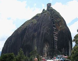
La Piedra de El Peñol, is a monolith
Monolith
A monolith is a geological feature such as a mountain, consisting of a single massive stone or rock, or a single piece of rock placed as, or within, a monument...
ic formation located at the town and municipality of Guatapé
Guatape
Guatapé is a town and municipality in Antioquia Department, Colombia. Part of the subregion of Eastern Antioquia. Guatapé is located in the outskirts of Medellín, bordering a reservoir created by the Colombian government for a hydro-electric dam, built in the late 1960s. This quaint town is the...
, 1 km inside the city limits (86 km northeast of Medellín
Medellín
Medellín , officially the Municipio de Medellín or Municipality of Medellín, is the second largest city in Colombia. It is in the Aburrá Valley, one of the more northerly of the Andes in South America. It has a population of 2.3 million...
) in Antioquia, Colombia
Colombia
Colombia, officially the Republic of Colombia , is a unitary constitutional republic comprising thirty-two departments. The country is located in northwestern South America, bordered to the east by Venezuela and Brazil; to the south by Ecuador and Peru; to the north by the Caribbean Sea; to the...
. The stone rises from the bottom of the hydroelectric dam of Peñol-Guatapé. This monolith was spotted as a border landmark between country farms and the two cities.
At its highest part, on the rear (southeast side), it has an elevation of 2135 metres (7,004.6 ft) over sea level. with an average temperature of 18 °C (64.4 °F). The "Peñón" has 185 cubic metres (6,533.2 cu ft) of rock mass and it is 385 metres (1,263.1 ft) long, with an approximate weight of 10000000 tonne. It has some rock breaks, one of which was used for the construction of the 644 stairs that can be used to go to the top.
The wide Antioquian rock base, called "batlolito antioqueño", and the "Peñón" were formed 70 million years ago.
The Tahamies Indians, former inhabitants of this region, worshipped the rock and called it on their language "mojarrá" or "mujará" (rock or stone). This rock is located in the country area called "La Piedra", just 5 minutes from Guatapé Town, and can be reached by road.
On the northern face of the stone are there painted large white letters, "G", and an incomplete "U" (only the single vertical stroke was completed). Guatapé and El Peñol had long disputed ownership of the rock, and the residents of Guatapé decided to settle the matter by painting the town's name on the rock in huge white letters. It did not take long for the residents of El Peñol to notice the work, and a large mob was assembled to stop it. Only the "G" and part of the "U" were completed.
The rock was climbed on July 1954. History tells that it was climbed by a group of friends, at the invitation of a local priest. Luis Villegas, Pedro Nel Ramírez and Ramón Díaz climbed the rock in a five-day endeavour, using sticks that were fixed against the rock's wall.
A new species of plant was found on the top of the rock, subsequently named Pitcairma heterophila by a German scientist.
A viewing spot was built on top of the rock, where it is possible to acquire handicrafts, postcards, and other local goods. It is possible to see the 500 km shore-perimeter dam.
In the 1940s, the Colombian government declared it a "National Monument".
Guatapé Major Office