

Eighth Street Crosstown Line
Encyclopedia
The Eighth Street Crosstown Line is a public transit line in Manhattan
, New York City
, United States
, running mostly along Eighth Street
, Ninth Street, Tenth Street, and Christopher Street
through the West Village
, Greenwich Village, and East Village
. Originally a streetcar line, it is now the M8 bus route, operated by the New York City Transit Authority
.
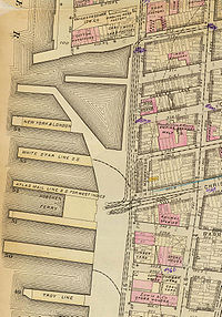 The Christopher and Tenth Street Railroad was chartered on April 25, 1873 and opened soon after (other sources give August 6, 1873 as the incorporation date). It traveled across the island between the Christopher Street Ferry on the Hudson River
and the East Tenth Street Ferry on the East River
. Tracks were built east from the Christopher Street Ferry dock to West Street, where it crossed the West Belt Line. Eastbound trains continued east on Christopher Street, while the westbound track curved north in West Street after crossing the West Belt Line and turned east on Tenth Street. The one-way pair
continued to Greenwich Avenue
, through which the Seventh Avenue Line
ran; cars turned southeast on Greenwich Avenue and east on Eighth Street along the Seventh Avenue Line tracks. The Seventh Avenue Line turned south at McDougal Street, while the Eighth Street Crosstown continued along Eighth Street to Cooper Square
. There the westbound track split to the northeast on Astor Place
/Stuyvesant Street
to reach Ninth Street, and the tracks were separated in Eighth and Ninth Streets to Avenue A
. Trains turned north in Avenue A for two blocks (eastbound) or one block (westbound), along Forty-Second Street and Grand Street Ferry Railroad
trackage, to Tenth Street, and then turned east again for the rest of the line to the East River. The trackage in Tenth Street east of Avenue C had been built by the Houston, West Street and Pavonia Ferry Railroad
.
On May 28, 1890, the Central Crosstown Railroad, which owned the 17th and 18th Streets Crosstown Line
from the Christopher Street Ferry east-northeast to the East 23rd Street Ferry, leased the Christopher and Tenth Street Railroad. The growing Metropolitan Street Railway acquired a majority of stock of the Central Crosstown in May 1897, and leased the companies on April 1, 1904. Two months after the Williamsburg Bridge
opened, on February 16, 1904, a second service pattern was added, taking some trains south on Avenue A and the one-way pair
of Essex Street
and Clinton Street (the latter via 1st Street) to reach Delancey Street
and the Williamsburg Bridge
, ending at a loop on the Brooklyn
side. Due to the Metropolitan's bankruptcy, their lines over the bridge were replaced in 1911 by a single one, the Seventh Avenue-Brooklyn Line, which shared trackage with the Seventh Avenue Line
from Central Park to Greenwich Village, turning east on the Eighth Street Crosstown Line and over the bridge to Brooklyn. That service was discontinued in 1919.
Buses were substituted for streetcars by the New York City Omnibus Corporation
on March 3, 1936. That company changed its name to Fifth Avenue Coach Lines in 1956; the Manhattan and Bronx Surface Transit Operating Authority
took over operations in 1962.
Because of economic troubles facing the MTA
in 2008–2009, the M8 bus was proposed for elimination. However, after community protests, the proposal was withdrawn in May 2009. But in June 2010, further budget cuts took away weekend and overnight service on this line.
Manhattan
Manhattan is the oldest and the most densely populated of the five boroughs of New York City. Located primarily on the island of Manhattan at the mouth of the Hudson River, the boundaries of the borough are identical to those of New York County, an original county of the state of New York...
, New York City
New York City
New York is the most populous city in the United States and the center of the New York Metropolitan Area, one of the most populous metropolitan areas in the world. New York exerts a significant impact upon global commerce, finance, media, art, fashion, research, technology, education, and...
, United States
United States
The United States of America is a federal constitutional republic comprising fifty states and a federal district...
, running mostly along Eighth Street
Eighth Street (Manhattan)
Eighth Street is a street in the New York City borough of Manhattan that runs from Sixth Avenue to Third Avenue, and Avenue B to Avenue D; it switches from west to east at Fifth Avenue. Between Third Avenue and Avenue A, the position in the grid that would be occupied by Eighth Street is known as...
, Ninth Street, Tenth Street, and Christopher Street
Christopher Street (Manhattan)
Christopher Street is a street in the West Village neighborhood of the New York City borough of Manhattan. It is the continuation of 9th St. to the west of its intersection with 6th Ave. The Stonewall Inn is located on Christopher Street, and, therefore, the street was at the center of New York's...
through the West Village
West Village, Manhattan
The West Village is the western portion of the Greenwich Village neighborhood in the New York City borough of Manhattan. The area is usually defined as bounded by the Hudson River on the west and either Sixth Avenue or Seventh Avenue on the east, extending from 14th Street down to Houston Street...
, Greenwich Village, and East Village
East Village, Manhattan
The East Village is a neighborhood in the borough of Manhattan in New York City, lying east of Greenwich Village, south of Gramercy and Stuyvesant Town, and north of the Lower East Side...
. Originally a streetcar line, it is now the M8 bus route, operated by the New York City Transit Authority
New York City Transit Authority
The New York City Transit Authority is a public authority in the U.S. state of New York that operates public transportation in New York City...
.
History
Hudson River
The Hudson is a river that flows from north to south through eastern New York. The highest official source is at Lake Tear of the Clouds, on the slopes of Mount Marcy in the Adirondack Mountains. The river itself officially begins in Henderson Lake in Newcomb, New York...
and the East Tenth Street Ferry on the East River
East River
The East River is a tidal strait in New York City. It connects Upper New York Bay on its south end to Long Island Sound on its north end. It separates Long Island from the island of Manhattan and the Bronx on the North American mainland...
. Tracks were built east from the Christopher Street Ferry dock to West Street, where it crossed the West Belt Line. Eastbound trains continued east on Christopher Street, while the westbound track curved north in West Street after crossing the West Belt Line and turned east on Tenth Street. The one-way pair
One-way pair
A one-way pair, one-way couple, or just couplet is a pair of parallel, usually one-way streets that carry opposite directions of a signed route or major traffic flow, or sometimes opposite directions of a bus or streetcar route....
continued to Greenwich Avenue
Greenwich Avenue (Manhattan)
Greenwich Avenue is a southeast-northwest avenue in Greenwich Village, in the New York City borough of Manhattan. It extends from the intersection of 6th Avenue and 8th Street at its southeast end to its northwestern end at 8th Avenue between 14th Street and 13th Street...
, through which the Seventh Avenue Line
Seventh Avenue Line (Manhattan surface)
The Seventh Avenue Line is a surface public transit line in Manhattan, New York City, United States, connecting Lower Manhattan with Central Park along Seventh Avenue...
ran; cars turned southeast on Greenwich Avenue and east on Eighth Street along the Seventh Avenue Line tracks. The Seventh Avenue Line turned south at McDougal Street, while the Eighth Street Crosstown continued along Eighth Street to Cooper Square
Cooper Square
__notoc__Cooper Square is a junction of streets in lower Manhattan, New York City located at the confluence of the neighborhoods of The Bowery to the south, NoHo to the west and southwest, Greenwich Village to the west and northwest, the East Village to the north and east, and the Lower East Side...
. There the westbound track split to the northeast on Astor Place
Astor Place (Manhattan)
__notoc__Astor Place is a short two-block street in lower Manhattan, New York City, which runs from Broadway just below East 8th Street, through Lafayette Street, past Cooper Square and Fourth Avenue, and ends at Third Avenue and St. Marks Place. The name is also used for the neighborhood around...
/Stuyvesant Street
Stuyvesant Street (Manhattan)
Stuyvesant Street is one of the oldest streets in the New York City borough of Manhattan. It runs diagonally from 9th Street at Third Avenue to 10th Street near Second Avenue, all within the East Village, Manhattan neighborhood. The majority of the street is included in the St...
to reach Ninth Street, and the tracks were separated in Eighth and Ninth Streets to Avenue A
Avenue A (Manhattan)
Avenue A runs from north to south and is the westernmost of the avenues to be defined by letters instead of using the numbering system in the New York City borough of Manhattan. Avenue A runs from Houston Street to 14th Street, where it continues into a loop road in Stuyvesant Town, connecting to...
. Trains turned north in Avenue A for two blocks (eastbound) or one block (westbound), along Forty-Second Street and Grand Street Ferry Railroad
Forty-Second Street and Grand Street Ferry Railroad
The Forty-second Street and Grand Street Ferry Railroad was a horse-drawn streetcar line in Manhattan, New York City, USA. It ran from the 42nd Street Ferry on the Hudson River to the Grand Street Ferry on the East River...
trackage, to Tenth Street, and then turned east again for the rest of the line to the East River. The trackage in Tenth Street east of Avenue C had been built by the Houston, West Street and Pavonia Ferry Railroad
Houston, West Street and Pavonia Ferry Railroad
The Houston, West Street and Pavonia Ferry Railroad was a street railway company in the U.S. state of New York. It owned and operated a system in Lower Manhattan, and became part of the Metropolitan Street Railway....
.
On May 28, 1890, the Central Crosstown Railroad, which owned the 17th and 18th Streets Crosstown Line
17th and 18th Streets Crosstown Line
The 17th and 18th Streets Crosstown Line was a public transit line in Manhattan, New York City, United States, running mostly along 14th Street, 17th Street, and 18th Street from the West 14th Street Ferry in Chelsea and Christopher Street Ferry in the West Village to the East 23rd Street Ferry at...
from the Christopher Street Ferry east-northeast to the East 23rd Street Ferry, leased the Christopher and Tenth Street Railroad. The growing Metropolitan Street Railway acquired a majority of stock of the Central Crosstown in May 1897, and leased the companies on April 1, 1904. Two months after the Williamsburg Bridge
Williamsburg Bridge
The Williamsburg Bridge is a suspension bridge in New York City across the East River connecting the Lower East Side of Manhattan at Delancey Street with the Williamsburg neighborhood of Brooklyn at Broadway near the Brooklyn-Queens Expressway...
opened, on February 16, 1904, a second service pattern was added, taking some trains south on Avenue A and the one-way pair
One-way pair
A one-way pair, one-way couple, or just couplet is a pair of parallel, usually one-way streets that carry opposite directions of a signed route or major traffic flow, or sometimes opposite directions of a bus or streetcar route....
of Essex Street
Essex Street (Manhattan)
Essex Street is a north-south street on the Lower East Side of the New York City borough of Manhattan. North of Houston Street, the street becomes Avenue A, and south of Canal Street it becomes Rutgers Street....
and Clinton Street (the latter via 1st Street) to reach Delancey Street
Delancey Street (Manhattan)
Delancey Street is one of the main thoroughfares of Manhattan's Lower East Side, running east from the Bowery to connect to the Williamsburg Bridge to Brooklyn. It is an eight-lane, median-divided street....
and the Williamsburg Bridge
Williamsburg Bridge
The Williamsburg Bridge is a suspension bridge in New York City across the East River connecting the Lower East Side of Manhattan at Delancey Street with the Williamsburg neighborhood of Brooklyn at Broadway near the Brooklyn-Queens Expressway...
, ending at a loop on the Brooklyn
Brooklyn
Brooklyn is the most populous of New York City's five boroughs, with nearly 2.6 million residents, and the second-largest in area. Since 1896, Brooklyn has had the same boundaries as Kings County, which is now the most populous county in New York State and the second-most densely populated...
side. Due to the Metropolitan's bankruptcy, their lines over the bridge were replaced in 1911 by a single one, the Seventh Avenue-Brooklyn Line, which shared trackage with the Seventh Avenue Line
Seventh Avenue Line (Manhattan surface)
The Seventh Avenue Line is a surface public transit line in Manhattan, New York City, United States, connecting Lower Manhattan with Central Park along Seventh Avenue...
from Central Park to Greenwich Village, turning east on the Eighth Street Crosstown Line and over the bridge to Brooklyn. That service was discontinued in 1919.
Buses were substituted for streetcars by the New York City Omnibus Corporation
New York City Omnibus Corporation
The New York City Omnibus Corporation was formed in 1926. It ran new bus services that replaced the New York Railways Corporation streetcars when they were dismantled in 1935/36. It purchased the Fifth Avenue Coach Company from The Omnibus Corporation in 1954 and renamed itself the 'Fifth Avenue...
on March 3, 1936. That company changed its name to Fifth Avenue Coach Lines in 1956; the Manhattan and Bronx Surface Transit Operating Authority
Manhattan and Bronx Surface Transit Operating Authority
The Manhattan and Bronx Surface Transit Operating Authority is a subsidiary of the New York City Transit Authority that was created in 1962 to take over bus services from the bankrupt Fifth Avenue Coach Company and Surface Transit, Inc...
took over operations in 1962.
Because of economic troubles facing the MTA
Metropolitan Transportation Authority (New York)
The Metropolitan Transportation Authority of the State of New York is a public benefit corporation responsible for public transportation in the U.S...
in 2008–2009, the M8 bus was proposed for elimination. However, after community protests, the proposal was withdrawn in May 2009. But in June 2010, further budget cuts took away weekend and overnight service on this line.