
Edgar Evins State Park
Encyclopedia
Edgar Evins State Park is a state park
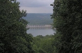
in DeKalb County, Tennessee, in the southeastern United States. The park consists of 6000 acres (24.3 km²) along the shores of Center Hill Lake
, an impoundment
of the Caney Fork. The State of Tennessee leases the land from the U.S. Army Corps of Engineers.
James Edgar Evins (1883–1954), the park's namesake, was a Smithville
businessman and state senator who played a vital role in the development of the Center Hill Dam and Reservoir in the 1940s. He was the father of former United States Representative Joe L. Evins
, for whom the nearby Joe L. Evins Appalachian Center for Craft is named. The Evins family began pushing for the establishment of a state park along the DeKalb portion of Center Hill Lake as early as the 1950s.
 The Caney Fork flows down from its source atop the Cumberland Plateau and winds its way northwestward across the Eastern Highland Rim
before emptying into the Cumberland River
near Carthage, Tennessee
. Center Hill Dam, located approximately 26.6 miles (42.8 km) above the mouth of the Caney Fork, has created a reservoir that spans a 68 miles (109.4 km) stretch of the river between the dam and the Great Falls Dam at Rock Island State Park
in adjacent Warren County. Edgar Evins State Park covers the northeast shore of the reservoir immediately upstream from Center Hill Dam.
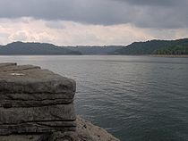
The park is situated amidst rolling hills ("knobs") that comprise part of the geological boundary between the Eastern Highland Rim
and the Central Basin
. These hills are typically underlain by Mississippian period limestone
, the erosion of which has created karst
-like formations throughout the Center Hill Basin. Outcroppings of this limestone are visible along the cliffs overlooking the lake.
Most of Edgar Evins State Park is coated in a second-growth hardwood forest typical of the Eastern Highland Rim. Common tree species include the tuliptree, white basswood, sugar maple
, white ash
, and various species of oak and hickory.
 A pre-inundation archaeological survey of the Center Hill Basin conducted by the Smithsonian Institution
located several possible prehistoric village and mound sites, including a 10 feet (3 m) platform mound at the mouth of Mine Lick Creek, just upstream from the modern park boundary. Early settlers in the area also claimed to have found Native American
graves and other objects. More extensive excavations, however, failed to uncover any major prehistoric sites.
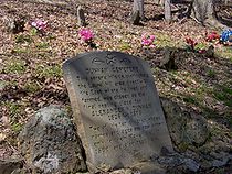
The earliest Euro-American settlers in the DeKalb area arrived in the late 1790s and established the town of Liberty
just west of the modern park. Over the years, several families settled in the hollows and valleys of what is now Edgar Evins State Park and adjacent lands that would eventually be inundated by Center Hill Lake. One such settler, Alexander Dunham (1826–1878), whose family arrived in the area in the 1830s, is buried on a hill within the park that overlooks Center Hill Lake. Dunham's son lived near the present site of Center Hill Dam.
The Caney Fork has long been notorious for its volatility. In the late 19th and early 20th centuries, business venture after business venture tried to harness the river's power, only to be defeated by one of several catastrophic floods that occurred along the river during this period. Major floods in 1902, 1915, 1928, and 1929 wiped out mills, bridges, houses, and farms, and led to increased calls for flood control. In the 1930s, the U.S. Army Corps of Engineers initiated several flood control projects in the Cumberland River
watershed, including Center Hill Dam, the construction of which was authorized in 1938. Flood control and power production were the primary goals of the Center Hill Dam project.
Center Hill Lake's revised management plan in the 1940s called for the inclusion of recreational areas along the lake's shores. These included several small local parks and boatramps at first. In the late 1960s, the State of Tennessee began construction of facilities for Edgar Evins State Park. The park was officially dedicated in 1975.
 Edgar Evins State Park maintains a 300-slip marina and full service dock. Various types of watercraft may be rented at the marina. Lodging areas include a 34-cabin lodging complex and a campground with both modern and primitive campsites.
Hiking trails maintained by the park include the 2 miles (3.2 km) Highland Rim Trail, which loops down, around, and back up through a hillside forest characteristic of the Eastern Highland Rim, and the Dunham Cemetery Trail, a short trail that ascends to a small cemetery where former resident Alexander Dunham and two of his children are buried (as of 2008, the trail was slated for expansion). The Millennium Trail consists of a 2.2 miles (3.5 km) loop that descends to the shores of Center Hill Lake and passes several pre-1940s homesteads (most of the ruins consist of rockwall-fences) before looping back into the forest. The Merritt Ridge Trail, a 5 miles (8 km) extension of the Millennium Trail, traverses Merritt Ridge, a steep ridge that became a peninsula with the reservoir's creation.
The Friends of Edgar Evins State Park was organized in 2003 to support park preservation efforts. The group conducts several annual tours of the park's flora, lake, and waterfalls.
State park
State parks are parks or other protected areas managed at the federated state level within those nations which use "state" as a political subdivision. State parks are typically established by a state to preserve a location on account of its natural beauty, historic interest, or recreational...
in DeKalb County, Tennessee, in the southeastern United States. The park consists of 6000 acres (24.3 km²) along the shores of Center Hill Lake
Center Hill Lake
Center Hill Lake is a reservoir in the U.S. state of Tennessee. It is located in Middle Tennessee near Smithville. Created by means of a dam constructed by the U.S. Army Corps of Engineers in 1948, the lake had a dual purpose: electricity production and flood control...
, an impoundment
Impoundment
Impoundment is the election of a President of the United States not to spend money that has been appropriated by the U.S. Congress. The precedent for presidential impoundment was first set by Thomas Jefferson in 1801. The power was available to all presidents up to and including Richard Nixon, and...
of the Caney Fork. The State of Tennessee leases the land from the U.S. Army Corps of Engineers.
James Edgar Evins (1883–1954), the park's namesake, was a Smithville
Smithville, Tennessee
Smithville is a city in DeKalb County, Tennessee, United States. The population was 3,994 at the 2000 census. It is the county seat of De Kalb County.-Geography:...
businessman and state senator who played a vital role in the development of the Center Hill Dam and Reservoir in the 1940s. He was the father of former United States Representative Joe L. Evins
Joe L. Evins
Joseph Landon Evins was a Democratic U.S. Representative from Tennessee from 1947 to 1977.Evins was a native of the Blend Community of DeKalb County, Tennessee, the son of James Edgar Evins and Myrtie Goodson Evins. His father was a Tennessee state senator and a successful local businessman.Joe L...
, for whom the nearby Joe L. Evins Appalachian Center for Craft is named. The Evins family began pushing for the establishment of a state park along the DeKalb portion of Center Hill Lake as early as the 1950s.
Geographical setting
Highland Rim
The Highland Rim is a geographic term for the area in Tennessee surrounding the Central Basin. Nashville is largely surrounded by higher terrain in all directions....
before emptying into the Cumberland River
Cumberland River
The Cumberland River is a waterway in the Southern United States. It is long. It starts in Harlan County in far southeastern Kentucky between Pine and Cumberland mountains, flows through southern Kentucky, crosses into northern Tennessee, and then curves back up into western Kentucky before...
near Carthage, Tennessee
Carthage, Tennessee
Carthage is a town in Smith County, Tennessee, United States, and is part of the Nashville Metropolitan Statistical Area. The population was 2,251 at the 2000 census. It is the county seat of Smith County, and perhaps best known as the hometown of former Vice President Al Gore, and his father,...
. Center Hill Dam, located approximately 26.6 miles (42.8 km) above the mouth of the Caney Fork, has created a reservoir that spans a 68 miles (109.4 km) stretch of the river between the dam and the Great Falls Dam at Rock Island State Park
Rock Island State Park (Tennessee)
Rock Island State Park is a state park in Warren County and White County, Tennessee, located in the Southeastern United States. The park is named after the community of Rock Island, Tennessee, which in turn received its name from an island on the Caney Fork upstream from the Collins River...
in adjacent Warren County. Edgar Evins State Park covers the northeast shore of the reservoir immediately upstream from Center Hill Dam.
The park is situated amidst rolling hills ("knobs") that comprise part of the geological boundary between the Eastern Highland Rim
Highland Rim
The Highland Rim is a geographic term for the area in Tennessee surrounding the Central Basin. Nashville is largely surrounded by higher terrain in all directions....
and the Central Basin
Nashville Basin
The Nashville Basin, also known as the Central Basin, is a term often used to describe the area surrounding Nashville, Tennessee. The Central Basin was caused by an uplifting known as the Nashville Dome. The Nashville Dome is evidenced by the underlying rock strata that all dip downwards away from...
. These hills are typically underlain by Mississippian period limestone
Limestone
Limestone is a sedimentary rock composed largely of the minerals calcite and aragonite, which are different crystal forms of calcium carbonate . Many limestones are composed from skeletal fragments of marine organisms such as coral or foraminifera....
, the erosion of which has created karst
KARST
Kilometer-square Area Radio Synthesis Telescope is a Chinese telescope project to which FAST is a forerunner. KARST is a set of large spherical reflectors on karst landforms, which are bowlshaped limestone sinkholes named after the Kras region in Slovenia and Northern Italy. It will consist of...
-like formations throughout the Center Hill Basin. Outcroppings of this limestone are visible along the cliffs overlooking the lake.
Most of Edgar Evins State Park is coated in a second-growth hardwood forest typical of the Eastern Highland Rim. Common tree species include the tuliptree, white basswood, sugar maple
Sugar Maple
Acer saccharum is a species of maple native to the hardwood forests of northeastern North America, from Nova Scotia west to southern Ontario, and south to Georgia and Texas...
, white ash
White Ash
For another species referred to as white ash, see Eucalyptus fraxinoides.Fraxinus americana is a species of Fraxinus native to eastern North America found in mesophytic hardwood forests from Nova Scotia west to Minnesota, south to northern Florida, and southwest to eastern...
, and various species of oak and hickory.
History
Smithsonian Institution
The Smithsonian Institution is an educational and research institute and associated museum complex, administered and funded by the government of the United States and by funds from its endowment, contributions, and profits from its retail operations, concessions, licensing activities, and magazines...
located several possible prehistoric village and mound sites, including a 10 feet (3 m) platform mound at the mouth of Mine Lick Creek, just upstream from the modern park boundary. Early settlers in the area also claimed to have found Native American
Native Americans in the United States
Native Americans in the United States are the indigenous peoples in North America within the boundaries of the present-day continental United States, parts of Alaska, and the island state of Hawaii. They are composed of numerous, distinct tribes, states, and ethnic groups, many of which survive as...
graves and other objects. More extensive excavations, however, failed to uncover any major prehistoric sites.
The earliest Euro-American settlers in the DeKalb area arrived in the late 1790s and established the town of Liberty
Liberty, Tennessee
Liberty is a town in DeKalb County, Tennessee, United States. The population was 367 at the 2000 census. Liberty's main street was listed on the National Register of Historic Places in 1987 as the Liberty Historic District.- History :...
just west of the modern park. Over the years, several families settled in the hollows and valleys of what is now Edgar Evins State Park and adjacent lands that would eventually be inundated by Center Hill Lake. One such settler, Alexander Dunham (1826–1878), whose family arrived in the area in the 1830s, is buried on a hill within the park that overlooks Center Hill Lake. Dunham's son lived near the present site of Center Hill Dam.
The Caney Fork has long been notorious for its volatility. In the late 19th and early 20th centuries, business venture after business venture tried to harness the river's power, only to be defeated by one of several catastrophic floods that occurred along the river during this period. Major floods in 1902, 1915, 1928, and 1929 wiped out mills, bridges, houses, and farms, and led to increased calls for flood control. In the 1930s, the U.S. Army Corps of Engineers initiated several flood control projects in the Cumberland River
Cumberland River
The Cumberland River is a waterway in the Southern United States. It is long. It starts in Harlan County in far southeastern Kentucky between Pine and Cumberland mountains, flows through southern Kentucky, crosses into northern Tennessee, and then curves back up into western Kentucky before...
watershed, including Center Hill Dam, the construction of which was authorized in 1938. Flood control and power production were the primary goals of the Center Hill Dam project.
Center Hill Lake's revised management plan in the 1940s called for the inclusion of recreational areas along the lake's shores. These included several small local parks and boatramps at first. In the late 1960s, the State of Tennessee began construction of facilities for Edgar Evins State Park. The park was officially dedicated in 1975.
The park today
Hiking trails maintained by the park include the 2 miles (3.2 km) Highland Rim Trail, which loops down, around, and back up through a hillside forest characteristic of the Eastern Highland Rim, and the Dunham Cemetery Trail, a short trail that ascends to a small cemetery where former resident Alexander Dunham and two of his children are buried (as of 2008, the trail was slated for expansion). The Millennium Trail consists of a 2.2 miles (3.5 km) loop that descends to the shores of Center Hill Lake and passes several pre-1940s homesteads (most of the ruins consist of rockwall-fences) before looping back into the forest. The Merritt Ridge Trail, a 5 miles (8 km) extension of the Millennium Trail, traverses Merritt Ridge, a steep ridge that became a peninsula with the reservoir's creation.
The Friends of Edgar Evins State Park was organized in 2003 to support park preservation efforts. The group conducts several annual tours of the park's flora, lake, and waterfalls.