
Easthaven
Encyclopedia

Subdivisions of Scotland
For local government purposes, Scotland is divided into 32 areas designated as "council areas" which are all governed by unitary authorities designated as "councils"...
of Angus
Angus
Angus is one of the 32 local government council areas of Scotland, a registration county and a lieutenancy area. The council area borders Aberdeenshire, Perth and Kinross and Dundee City...
, Scotland. It is situated 1.5 miles (2 km) east of Carnoustie
Carnoustie
Carnoustie is a town and former police burgh in the council area of Angus, Scotland. It is situated at the mouth of the Barry Burn on the North Sea coast...
and 5 miles (8 km) south west of Arbroath
Arbroath
Arbroath or Aberbrothock is a former royal burgh and the largest town in the council area of Angus in Scotland, and has a population of 22,785...
. The closest city, Dundee
Dundee
Dundee is the fourth-largest city in Scotland and the 39th most populous settlement in the United Kingdom. It lies within the eastern central Lowlands on the north bank of the Firth of Tay, which feeds into the North Sea...
, is 13 miles (21 km) to the west.
East Haven has a long history and is first recorded (as 'Stinchendehavene') in deeds granted in 1214 by Philip de Valognes
Philip de Valognes
Philip de Valognes, fifth son of Roger de Valognes, came to Scotland around 1165, at the end of Malcolm IV's reign. He was the attendant of William the Lion and was one of the hostages for his release named in the Treaty of Falaise in 1174...
, Lord of Panmure, to the Cistercian monks of Coupar Angus
Coupar Angus
Coupar Angus is a town in Perth and Kinross, Scotland, situated eight kilometres south of Blairgowrie.The name Coupar Angus serves to differentiate the town from Cupar, Fife...
, which gave them rights to build on the land there, to use the haven and to impose a toll on the fishings. East Haven can be seen on Pont's
Timothy Pont
Timothy Pont was a Scottish topographer, the first to produce a detailed map of Scotland. Pont's maps are among the earliest surviving to show a European country in minute detail, from an actual survey.-Life:...
map of Lower Angus, c1583-96., spelled 'East Heaven'. It has been known under various other names including 'Ross Haven', 'Mauleshaven' and 'Stinking Haven'. Formerly, a small fishing fleet operated from the natural harbour, catching cod
Cod
Cod is the common name for genus Gadus, belonging to the family Gadidae, and is also used in the common name for various other fishes. Cod is a popular food with a mild flavor, low fat content and a dense, flaky white flesh. Cod livers are processed to make cod liver oil, an important source of...
and haddock
Haddock
The haddock , also known as the offshore hake, is a marine fish distributed on both sides of the North Atlantic. Haddock is a popular food fish and is widely fished commercially....
which were sold in markets in Dundee
Dundee
Dundee is the fourth-largest city in Scotland and the 39th most populous settlement in the United Kingdom. It lies within the eastern central Lowlands on the north bank of the Firth of Tay, which feeds into the North Sea...
and Forfar
Forfar
Forfar is a parish, town and former royal burgh of approximately 13,500 people in Angus, located in the East Central Lowlands of Scotland. Forfar is the county town of Angus, which was officially known as Forfarshire from the 18th century until 1929, when the ancient name was reinstated, and...
, as well as Lobsters for export to London
London
London is the capital city of :England and the :United Kingdom, the largest metropolitan area in the United Kingdom, and the largest urban zone in the European Union by most measures. Located on the River Thames, London has been a major settlement for two millennia, its history going back to its...
and crabs for local use.
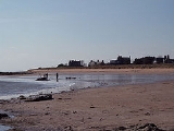
The beach at East Haven is popular with families from the local area during Summer months, and the Royal Family were regular visitors while holidaying at Glamis in the 1930s.
Several of the houses are situated only a few feet from the beach, a rocky and often windy sweep of sand typical of Scotland's rugged coastline, and so are popular both as permanent residences or summer houses.
In 1838, construction of the Dundee and Arbroath Railway
Dundee and Arbroath Railway
The Dundee and Arbroath Railway was a railway link between those two towns in Scotland.-History:The railway company received its Parliamentary Act on 19 May 1836. It was planned as a gauge railway, because, at that time, it was expected to be a purely local railway with no connection to the...
was completed, its route cutting through the village. East Haven was formerly served by a small railway station which closed in 1967. Twenty houses lie on land on the seaward side of the railway. These were formerly served by a private level crossing which was closed in 2003, leaving them inaccessible by vehicles larger than a car.
The village is on land owned by a limited company originally set up by a group of individuals who own the line of bigger houses to the west. The path that runs to the east is on top of sea defences that are formed from the stone recovered when the nearby Panmure Estate Mansion was demolished.
The village has a great outlook, although is exposed.