
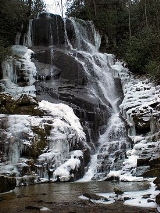
Eastatoe Falls
Encyclopedia
Eastatoe Falls is a waterfall
in Western North Carolina
, United States, located on private property near Rosman
.
between Nancy Mountain and Burnt Mountain near the Eastatoe Gap. The creek descends over 200 feet over a quarter mile, culminating in the 60 foot series of drops over granite bedrock at Eastatoe Falls. The creek continues on past the falls to join with other tributaries to form the Middle Fork French Broad River.
word for the Carolina Parakeet
, and was the name of a local tribe of Cherokee. Ownership of the falls has changed throughout the years, as has the name. The falls has been called Will Hines Falls, Shoal Creek Falls, and Rosman Falls.
Buttermilk Falls is located on private property off of State Road 1105. The falls is viewable from the road. From the intersection of US 64 and US 178, follow US 178 south for 1.6 miles and turn left of East Fork Road. Stay on East Fork Road for a total of 4.9 miles (bearing right at 3.6 miles). Turn right onto Glady Fork Road and go 1 mile to a poor view of the waterfall on the left.
Other falls in the region include:
Waterfall
A waterfall is a place where flowing water rapidly drops in elevation as it flows over a steep region or a cliff.-Formation:Waterfalls are commonly formed when a river is young. At these times the channel is often narrow and deep. When the river courses over resistant bedrock, erosion happens...
in Western North Carolina
North Carolina
North Carolina is a state located in the southeastern United States. The state borders South Carolina and Georgia to the south, Tennessee to the west and Virginia to the north. North Carolina contains 100 counties. Its capital is Raleigh, and its largest city is Charlotte...
, United States, located on private property near Rosman
Rosman, North Carolina
Rosman is a town in Transylvania County, North Carolina, United States. The population was 490 at the 2000 census. The northern terminus of U.S. Route 178 is less than one mile northwest of Rosman on U.S...
.
Shoal Creek
Shoal Creek rises in the Pisgah National ForestPisgah National Forest
Pisgah National Forest is a National Forest in the Appalachian Mountains of western North Carolina. It is administered by the United States Forest Service, part of the United States Department of Agriculture. The Pisgah National Forest is completely contained within the state of North Carolina...
between Nancy Mountain and Burnt Mountain near the Eastatoe Gap. The creek descends over 200 feet over a quarter mile, culminating in the 60 foot series of drops over granite bedrock at Eastatoe Falls. The creek continues on past the falls to join with other tributaries to form the Middle Fork French Broad River.
Natural history
"Eastatoe" was the local CherokeeCherokee language
Cherokee is an Iroquoian language spoken by the Cherokee people which uses a unique syllabary writing system. It is the only Southern Iroquoian language that remains spoken. Cherokee is a polysynthetic language.-North American etymology:...
word for the Carolina Parakeet
Carolina Parakeet
The Carolina Parakeet was the only parrot species native to the eastern United States. It was found from the Ohio Valley to the Gulf of Mexico, and lived in old forests along rivers. It was the only species at the time classified in the genus Conuropsis...
, and was the name of a local tribe of Cherokee. Ownership of the falls has changed throughout the years, as has the name. The falls has been called Will Hines Falls, Shoal Creek Falls, and Rosman Falls.
Visiting the Falls
The falls is located on private property whose owners allow access. From the junction of US Highway 64 and US Highway 178 in Rosman, follow US 178 south for 3.4 miles and turn right into the private driveway. Park at the parking area between the house and the now-closed Mountain Meadow Craft Shop. Follow the short, easy trail for about 200 yards to a viewing area of the falls. Visitors to the falls should respect the owner's private property and privacy by not visiting early in the morning or late in the day, letting pets run off-leash, blocking their driveway, or littering.Nearby Falls
Claypole Falls drains the cove to the west of Eastatoe Falls, but is located on private property and is not accessible to the public.Buttermilk Falls is located on private property off of State Road 1105. The falls is viewable from the road. From the intersection of US 64 and US 178, follow US 178 south for 1.6 miles and turn left of East Fork Road. Stay on East Fork Road for a total of 4.9 miles (bearing right at 3.6 miles). Turn right onto Glady Fork Road and go 1 mile to a poor view of the waterfall on the left.
Other falls in the region include:
- Pounding Mill Falls
- Chestnut Falls
- Kiesee Falls
- Dill Falls
- French Broad and Mill Shoals Falls
- Bird Rock Falls
- Courthouse FallsCourthouse FallsCourthouse Falls is a waterfall in Western North Carolina, located near Balsam Grove.-Geology:Courthouse Creek flows near in the Pisgah National Forest near a mountain called the Devil's Courthouse. Courthouse Creek flows through a narrow chute into a natural amphitheater of bedrock.-Visiting the...
- Boren Mill Shoals