

East Gippsland
Encyclopedia
East Gippsland is the eastern region of Gippsland
Gippsland
Gippsland is a large rural region in Victoria, Australia. It begins immediately east of the suburbs of Melbourne and stretches to the New South Wales border, lying between the Great Dividing Range to the north and Bass Strait to the south...
, Australia
Australia
Australia , officially the Commonwealth of Australia, is a country in the Southern Hemisphere comprising the mainland of the Australian continent, the island of Tasmania, and numerous smaller islands in the Indian and Pacific Oceans. It is the world's sixth-largest country by total area...
covering 31,740 square kilometres (14%) of Victoria
Victoria (Australia)
Victoria is the second most populous state in Australia. Geographically the smallest mainland state, Victoria is bordered by New South Wales, South Australia, and Tasmania on Boundary Islet to the north, west and south respectively....
. It has a population of 80,114.
The Shire of East Gippsland, also called Far East Gippsland, covers two-thirds (66%) of East Gippsland's area and holds half (50.0%) of its population.
The Shire of East Gippsland is confusingly also referred to simply as East Gippsland. It excludes the Shire of Wellington (Central Gippsland
Central Gippsland
The area known as Central Gippsland, also termed North Gippsland, is a region of Gippsland in Victoria, Australia, roughly corresponding to Shire of Wellington...
). This article (currently) refers mainly to "Far East Gippsland".
East Gippsland's major towns include, from west to east, Bairnsdale
Bairnsdale, Victoria
Bairnsdale is a small city in Gippsland, Victoria, Australia. With a population at the 2006 census of 11,282, it is a major regional centre of eastern Victoria along with Traralgon and Sale....
(the largest town and administrative centre), Lakes Entrance
Lakes Entrance, Victoria
Lakes Entrance is a tourist resort and fishing port in eastern Victoria, Australia. It is situated approximately east of Melbourne, near a managed, man-made channel connecting the Gippsland Lakes to the Bass Strait. At the 2006 census, Lakes Entrance had a population of 4,094.The township was...
, Orbost
Orbost, Victoria
Orbost is a town in the Shire of East Gippsland, Victoria, Australia, located east of Melbourne and south of Canberra where the Princes Highway crosses the Snowy River. It is about from the town of Marlo on the coast of Bass Strait. At the 2006 census, Orbost had a population of 2452...
,Paynsville and Mallacoota
Mallacoota, Victoria
-External links:***...
. Smaller, but significant, towns in the more mountainous northern areas include Ensay, Swifts Creek
Swifts Creek, Victoria
Swifts Creek is a rural community located between Omeo and Ensay on the Great Alpine Road in East Gippsland, Victoria, Australia, east of the state capital Melbourne. Swifts Creek is at an altitude of 300 m above sea level. The area was originally settled by Europeans in the gold rushes of the mid...
, Omeo
Omeo, Victoria
Omeo is a town in Victoria, Australia, located on the Great Alpine Road, east of Mount Hotham, in the Shire of East Gippsland. At the 2006 census, Omeo had a population of 452. The name is derived from the Aboriginal word for 'mountains' or 'hills'...
, and Buchan
Buchan, Victoria
Buchan is a town in Victoria, Australia, located on Buchan Road, in the Shire of East Gippsland near the Snowy River. At the 2006 census, Buchan and the surrounding area had a population of 326....
.
East Gippsland extends from the western watershed of the Mitchell and Thomson River catchments east and north to the New South Wales
New South Wales
New South Wales is a state of :Australia, located in the east of the country. It is bordered by Queensland, Victoria and South Australia to the north, south and west respectively. To the east, the state is bordered by the Tasman Sea, which forms part of the Pacific Ocean. New South Wales...
border. Rugged terrain makes farming difficult, even with fertilisers.
The major industry is often considered to be forestry, which provides less than 1 percent of employment for the region. The East Gippsland Regional Forest Agreement
Regional Forest Agreement
The Regional Forest Agreements are 20 year plans for the conservation and sustainable management of Australia's native forests, and are intended to provide certainty to commercial forestry operations while protecting environmental values. The 10 RFA's were progressively signed between 1997 and 2001...
(RFA) was signed by Commonwealth
Government of Australia
The Commonwealth of Australia is a federal constitutional monarchy under a parliamentary democracy. The Commonwealth of Australia was formed in 1901 as a result of an agreement among six self-governing British colonies, which became the six states...
and Victorian
Government of Victoria
The Government of Victoria, under the Constitution of Australia, ceded certain legislative and judicial powers to the Commonwealth, but retained complete independence in all other areas...
governments on 3 February 1997, and is Australia's first RFA. It covers a region similar, but not identical to the East Gippsland Shire. It sets aside 5,811 km² from logging, an increase of 1.3% over pre-RFA reserves. Central Gippsland is covered by the Gippsland RFA (Signed 31 March 2000), which covers an area similar to the Shire of Wellington, and places 7,805 km² in reserves.
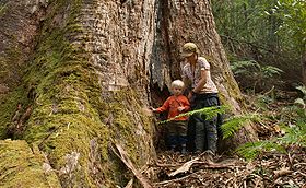
Logging of native forests has caused sustained controversy in East Gippsland, particularly due to the unique species found in areas east of the Snowy River, and the contentious public debate surrounding native forest, particularly old-growth, harvesting. This is despite managed forest having a mitigation effect in climate change
Global warming
Global warming refers to the rising average temperature of Earth's atmosphere and oceans and its projected continuation. In the last 100 years, Earth's average surface temperature increased by about with about two thirds of the increase occurring over just the last three decades...
.
The major river basins of the Mitchell, Tambo and Nicholson drain into the Gippsland Lakes
Gippsland Lakes
The Gippsland Lakes are a network of lakes, marshes and lagoons in east Gippsland, Victoria, Australia covering an area of about 600 km2. The largest of the lakes are Lake Wellington , Lake King and Lake Victoria. They are fed by the Avon, Thomson, Latrobe, Mitchell, Nicholson and Tambo...
, which in turn empty into the sea through an artificially maintained opening at Lakes Entrance
Lakes Entrance, Victoria
Lakes Entrance is a tourist resort and fishing port in eastern Victoria, Australia. It is situated approximately east of Melbourne, near a managed, man-made channel connecting the Gippsland Lakes to the Bass Strait. At the 2006 census, Lakes Entrance had a population of 4,094.The township was...
.
The area is a major tourist destination, especially for watersports, and is noted for its mild climate. The Great Alpine Road
Great Alpine Road
The Great Alpine Road is a country tourist road in Victoria, Australia, running from Wangaratta in the north to Bairnsdale in the east, and passing through the Australian Alps...
leads north from Bairnsdale into the Australian Alps
Australian Alps
The Australian Alps are the highest mountain ranges of mainland Australia. They are located in southeastern Australia and straddle the Australian Capital Territory, south-eastern New South Wales and eastern Victoria...
via Swifts Creek
Swifts Creek, Victoria
Swifts Creek is a rural community located between Omeo and Ensay on the Great Alpine Road in East Gippsland, Victoria, Australia, east of the state capital Melbourne. Swifts Creek is at an altitude of 300 m above sea level. The area was originally settled by Europeans in the gold rushes of the mid...
and Omeo
Omeo, Victoria
Omeo is a town in Victoria, Australia, located on the Great Alpine Road, east of Mount Hotham, in the Shire of East Gippsland. At the 2006 census, Omeo had a population of 452. The name is derived from the Aboriginal word for 'mountains' or 'hills'...
, and onto the major ski resorts of Dinner Plain
Dinner Plain, Victoria
Dinner Plain is a town in Victoria, Australia, located on the Great Alpine Road, 10 kilometres from Mount Hotham Alpine Resort, and 375 kilometres from Melbourne. At the 2006 census, Dinner Plain had a population of 88, yet has over 200 lodges and chalets for tourist accommodation...
and Mount Hotham
Mount Hotham
Mount Hotham is a mountain in Victoria, Australia. It is home to Hotham Alpine Resort. The mountain is located approximately north east of Melbourne, from Sydney, and from Adelaide by road. Mt Hotham's summit rises to an altitude of above sea level...
. This area is also very popular for bushwalking in the summer. The Buchan
Buchan
Buchan is one of the six committee areas and administrative areas of Aberdeenshire Council, Scotland. These areas were created by the council in 1996, when the Aberdeenshire unitary council area was created under the Local Government etc Act 1994...
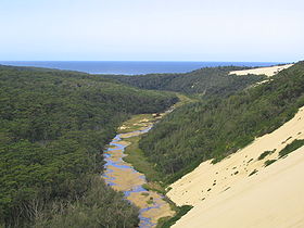
district is popular with tourists for its limestone caves. Further east, the Snowy River
Snowy River
The Snowy River is a major river in south-eastern Australia. It originates on the slopes of Mount Kosciuszko, Australia's highest mainland peak, draining the eastern slopes of the Snowy Mountains in New South Wales, before flowing through the Snowy River National Park in Victoria and emptying into...
and several smaller stream catchments, including the Thurra, Wingan, Genoa, Bemm River and Cann River
Cann River
The Cann River is a river of Gippsland in southeastern Victoria, Australia. It arises in the Bondi Forest in New South Wales and flows south to the Croajingolong National Park before entering Bass Strait via Tamboon Inlet....
, enter the Tasman Sea
Tasman Sea
The Tasman Sea is the large body of water between Australia and New Zealand, approximately across. It extends 2,800 km from north to south. It is a south-western segment of the South Pacific Ocean. The sea was named after the Dutch explorer Abel Janszoon Tasman, the first recorded European...
.
Snowy River National Park
Snowy River is a national park in Victoria , 323 km east of Melbourne.Much of the park is classified as wilderness area, where vehicles are unable to visit. The park provides one of the last natural habitats at the Little River Gorge for the endangered brush-tailed rock wallaby...
and Errinundra National Park
Errinundra National Park
Errinundra is a national park in Victoria, Australia, 352 km east of Melbourne. Errinundra National Park is centred on the Errinundra Plateau, a southwards extension of the Monaro Tablelands of New South Wales...
. Both are remote and inaccessible, but they are otherwise entirely different. Snowy River National Park features dramatic gorges and powerful rapids formed by the descent of the Snowy River
Snowy River
The Snowy River is a major river in south-eastern Australia. It originates on the slopes of Mount Kosciuszko, Australia's highest mainland peak, draining the eastern slopes of the Snowy Mountains in New South Wales, before flowing through the Snowy River National Park in Victoria and emptying into...
. Apart from gorges and southern slopes, this park is in a rain-shadow area forming the southern border of the Monaro Tableland
Monaro, New South Wales
Monaro is the name of a region in the south of New South Wales, Australia. A small area of Victoria near Snowy River National Park is geographically part of the Monaro, whilst the Australian Capital Territory is frequently considered part of the region: most towns have very close links with...
. Consequently, many species more typical of inland New South Wales and Victoria are found here. Errinundra National Park is much wetter - inaccessible from June to October in most years - and features some of the most ancient forests in Australia, a matter of controversy as employment in the remote areas east of the Snowy is mainly dependent upon timber milling. Croajingolong National Park
Croajingolong National Park
Croajingolong is a coastal national park in Victoria, Australia, 427 kilometres east of Melbourne.The name is thought to derive from the aboriginal word Krowathunkooloong, the name of the tribe inhabiting that area of Victoria.-Description:...
between Marlo
Marlo
Marlo may refer to:*Marlo Thomas , American actress*Marlo, Norway*Marlo, Victoria, a town near the mouth of the Snowy River in Australia*Marlo Stanfield, a fictional character on the television series The Wire...
and Mallacoota features extensive coastal heathlands and tea tree
Tea tree
Tea tree or Ti-tree is a popular name that has been applied to a number of different, unrelated plants:*Camellia sinensis , from which black, green, oolong and white tea are all obtained....
scrub, as well as the only major area of warm temperate rainforest in Victoria. The 4,193 km² of privately owned land is mainly red gum plains, coastal plains, mountain plateaux and fertile river valleys.
See also
- Electoral district of Gippsland EastElectoral district of Gippsland EastThe Electoral district of Gippsland East is an electoral district of the Victorian Legislative Assembly. It covers most of eastern Victoria and includes the towns of Bairnsdale, Lakes Entrance, Orbost, Omeo, Maffra and Heyfield....
- Shire of East Gippsland
- Forests of AustraliaForests of AustraliaAustralia has many forests of importance due to significant features, despite being one of the driest continents. Australia has approximately 147 million hectares of native forest which represents some 19% of land use....
- East Gippsland Catchment Management AuthorityEast Gippsland Catchment Management AuthorityThe East Gippsland Catchment Management Authority covers 22,000 km² of land, lakes and coastal waters in the easternmost part of Victoria.About 80% of the land of the region is in public ownership, mainly as State Forests and National Parks...