
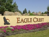
Eagle Crest Resort
Encyclopedia
Eagle Crest Resort is a destination resort complex in the U.S. state
of Oregon
. The resort has a large hotel, a conference center, three golf courses, and three major housing developments each with multiple subdivisions. The resort is located west of Redmond
in Central Oregon
. The development covers 1700 acres (6.9 km²) on the east slopes of Cline Butte running eastward to the Deschutes River plus a separate area on the northwest side of the butte.
The portion of Eagle Crest east of Cline Butte is located on the Matson Plateau. This area is generally flat with gentle swales sloping gradually down hill to the east until it reaches the edge of the Deschutes River canyon. Most of the area, around Cline Butte, including all of Eagle Crest, is western juniper woodland. In addition to juniper, there are also some native stands of lodgepole pine
in the area. The area’s ground cover is dominated by bitterbrush, sagebrush
, gray rabbitbrush
, and other high desert
plants. The plateau ends at the cliff edge just above the Deschutes River. The river flows through a deep canyon with 100 feet (30.5 m) high basalt
cliffs on both sides. Eagle Crest owns approximately one and a half miles of Deschutes River frontage on the west bank.
. Built in 1989, the Inn at Eagle Crest is located next to one of the resort’s three golf courses. There are 100 rooms in the main hotel and 80 condominium units that are part of the resort's lodging facility. Many of its guest rooms have decks or patios facing the golf course. Smith Rock
is northeast of the resort and can also be seen from many of the rooms. A large number of the condominiums overlook the Deschutes River canyon. The resort also operates a large conference center, three 18-hole golf courses, spa
facilities, two sports and fitness centers, three outdoor pools, an indoor pool, and numerous other amenities. The resort has 13 miles (20.9 km) of paved paths for biking, jogging
, and walks. There is also a hiking trail running two miles (3 km) along the west bank of the Deschutes River.
The Eagle Crest conference center is located adjacent to the Inn at Eagle Crest. It is a 10000 square feet (929 m²) facility with two separate conference areas. The larger area called Juniper Hall can accommodate 600 people for lectures or 425 banquet guests. The other conference area is known as the Golden Eagle Ballroom. It accommodates 511 people in a theatre configuration or 360 when arranged for banquets. Both the hall and the ballroom can be subdivided into smaller meeting rooms. This allows the center to handle as many as six smaller conferences, meeting, lectures, receptions, or luncheons at one time.
golf tournament has been held at the Ridge Course. The Challenge Course is an 18 hole par-63; however, it only covers 4,160 yards so it can be played in about three hours. It offers four tee boxes at each hole so the course is popular with beginners as well as experienced golfers. All three courses are open from mid-March through the first week in November. Either the Ridge or the Resort course is kept open year around, weather permitting.
In 1996, Eagle Crest began selling lots west of the Cline Falls Highway in the area of the Ridge golf course, which was completed in 1993. This second phase of development, is known as The Ridge. This area continued to grow as the Challenge golf course was built in 1999. Eagle Crest continued to sell housing lots in the ridge area for over a decade, and construction of new homes was still going on in 2009. There are five distinct subdivisions in the Ridge area: Forest Greens, Eagle Springs, Forest Ridge, Eagle Creek, and The Falls. The Falls is a community with 280 unit specifically for retired adults, 55 or older. The Falls has its own community center and private sports facility.
The third and final phase of Eagle Crest housing includes six distinct areas located northwest of Cline Butte. This area is separated from the Ridge area by approximately one mile of Bureau of Land Management property. However, there is a paved easement road that connects the two areas. The largest subdivision in this area is known as the West Ridge. The West Ridge development covers the lower slope of Cline Butte, and has approximately 425 lots for stand alone homes. The Creekside subdivision has 152 townhouses located near the West Ridge sports center. The Highland Park area has 41 smaller lots. There are over 100 lots in the Desert Sky subdivision. Houses in the Desert Sky area are all built in the western ranch style. Vista Rim was the last subdivision developed at Eagle Crest. Lots in that area began selling in 2008. There is also a small gated area with eight 1 acres (4,046.9 m²) properties called Scenic Ridge. These high-end properties are located on the western edge of the Eagle Crest with views of all the Cascade Mountains from Mount Bachelor
to Mount Hood
.
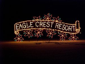 Each winter Eagle Crest Resort host StarFest, a night-time light display that begins on Thanksgiving
and runs through New Year’s Day. The lights are illuminated every evening from 5:30 p.m. until 9:30 p.m. along a one mile (1.6 km) drive through the resort. Admission to StarFest is free.
During StarFest, the Inn at Eagle Crest offers visitors coffee, hot cocoa, and cookies along with a fireside story time with Mrs. Claus. On weekends, a horse-drawn wagon provides rides for a modest fee. Reservations for StarFest wagon rides can be arranged through the Inn’s concierge. While StarFest is always popular with resort guests, a drive-through visit to see the light display with a stop off at the Inn has become a holiday tradition with many families in Central Oregon.
U.S. state
A U.S. state is any one of the 50 federated states of the United States of America that share sovereignty with the federal government. Because of this shared sovereignty, an American is a citizen both of the federal entity and of his or her state of domicile. Four states use the official title of...
of Oregon
Oregon
Oregon is a state in the Pacific Northwest region of the United States. It is located on the Pacific coast, with Washington to the north, California to the south, Nevada on the southeast and Idaho to the east. The Columbia and Snake rivers delineate much of Oregon's northern and eastern...
. The resort has a large hotel, a conference center, three golf courses, and three major housing developments each with multiple subdivisions. The resort is located west of Redmond
Redmond, Oregon
Redmond is a city in Deschutes County, Oregon, United States. Incorporated on July 6, 1910, the city is located on the eastern side of Oregon's Cascade Range, in the High Desert, and is considered the geographical heart of Central Oregon...
in Central Oregon
Central Oregon
Central Oregon is a geographic region in the U.S. state of Oregon and is traditionally considered to be made up of Deschutes, Jefferson, and Crook counties. Other definitions include larger areas, often encompassing areas to the north towards the Columbia River, eastward towards Burns, or south...
. The development covers 1700 acres (6.9 km²) on the east slopes of Cline Butte running eastward to the Deschutes River plus a separate area on the northwest side of the butte.
Geography
Eagle Crest is located six miles (10 km) west of Redmond on the Deschutes River. The Eagle Crest property includes the lower slope of Cline Butte on the eastern side, extending approximately one and a half miles to the Deschutes River, and one and a half miles north to south with Oregon Highway 126 as the northern boundary. The resort's main entrance is just off the Cline Falls Highway, approximately one mile south of Highway 126. In addition to the resort's main area east of Cline Butte, there is a large, separate parcel of Eagle Crest property northwest of the butte. This area has an entrance road connecting it directly to Highway 126. In total, Eagle Crest covers 1700 acres (6.9 km²).The portion of Eagle Crest east of Cline Butte is located on the Matson Plateau. This area is generally flat with gentle swales sloping gradually down hill to the east until it reaches the edge of the Deschutes River canyon. Most of the area, around Cline Butte, including all of Eagle Crest, is western juniper woodland. In addition to juniper, there are also some native stands of lodgepole pine
Lodgepole Pine
Lodgepole Pine, Pinus contorta, also known as Shore Pine, is a common tree in western North America. Like all pines, it is evergreen.-Subspecies:...
in the area. The area’s ground cover is dominated by bitterbrush, sagebrush
Sagebrush
Sagebrush is a common name of a number of shrubby plant species in the genus Artemisia native to western North America;Or, the sagebrush steppe ecoregion, having one or more kinds of sagebrush, bunchgrasses and others;...
, gray rabbitbrush
Chrysothamnus nauseosus
Ericameria nauseosa , commonly known as Chamisa, rubber rabbitbrush, and gray rabbitbrush, is a shrub of the genus Ericameria that grows in the arid regions of western North America. Two subspecies have been described, nauseosa and consimilis...
, and other high desert
High Desert (Oregon)
The Oregon High Desert is a region of the U.S. state of Oregon, located east of the Cascade Range and south of the Blue Mountains, in the central and eastern parts of the state. Divided into a southern region and a northern region, the desert covers most of five Oregon counties and averages above...
plants. The plateau ends at the cliff edge just above the Deschutes River. The river flows through a deep canyon with 100 feet (30.5 m) high basalt
Basalt
Basalt is a common extrusive volcanic rock. It is usually grey to black and fine-grained due to rapid cooling of lava at the surface of a planet. It may be porphyritic containing larger crystals in a fine matrix, or vesicular, or frothy scoria. Unweathered basalt is black or grey...
cliffs on both sides. Eagle Crest owns approximately one and a half miles of Deschutes River frontage on the west bank.
Resort
The Eagle Crest is one of eight destination resorts as defined by Oregon's Department of Land Conservation and DevelopmentOregon Department of Land Conservation and Development
The Oregon Department of Land Conservation and Development is the chief land use planning and regulatory agency of the government of the U.S. state of Oregon. The DLCD administers the statewide land use planning program...
. Built in 1989, the Inn at Eagle Crest is located next to one of the resort’s three golf courses. There are 100 rooms in the main hotel and 80 condominium units that are part of the resort's lodging facility. Many of its guest rooms have decks or patios facing the golf course. Smith Rock
Smith Rock State Park
Smith Rock State Park is a state park located in central Oregon's high desert near the towns of Redmond and Terrebonne. Its sheer cliffs of tuff and basalt are ideal for rock climbing of all difficulty levels...
is northeast of the resort and can also be seen from many of the rooms. A large number of the condominiums overlook the Deschutes River canyon. The resort also operates a large conference center, three 18-hole golf courses, spa
Spa
The term spa is associated with water treatment which is also known as balneotherapy. Spa towns or spa resorts typically offer various health treatments. The belief in the curative powers of mineral waters goes back to prehistoric times. Such practices have been popular worldwide, but are...
facilities, two sports and fitness centers, three outdoor pools, an indoor pool, and numerous other amenities. The resort has 13 miles (20.9 km) of paved paths for biking, jogging
Jogging
Jogging is a form of trotting or running at a slow or leisurely pace. The main intention is to increase fitness with less stress on the body than from faster running.-Definition:...
, and walks. There is also a hiking trail running two miles (3 km) along the west bank of the Deschutes River.
The Eagle Crest conference center is located adjacent to the Inn at Eagle Crest. It is a 10000 square feet (929 m²) facility with two separate conference areas. The larger area called Juniper Hall can accommodate 600 people for lectures or 425 banquet guests. The other conference area is known as the Golden Eagle Ballroom. It accommodates 511 people in a theatre configuration or 360 when arranged for banquets. Both the hall and the ballroom can be subdivided into smaller meeting rooms. This allows the center to handle as many as six smaller conferences, meeting, lectures, receptions, or luncheons at one time.
Golf courses
The resort's three golf courses are all well known and very popular. The Resort Course, adjacent to the Inn, is the resort’s original golf course. It is an 18 hole 6,673 yards, par-72 course designed by Gene Mason. The course runs along the rim of the Deschutes River canyon and throughout the original Eagle Crest housing development. The most spectacular holes follow the cliffs overlooking the river, 100 feet (30.5 m) below. The Ridge Course was designed by John Thronson. It is an 18 hole 6,927 yard, par-72 course that threads its way through native juniper trees with the Cascade Mountains in the background. The Oregon OpenOregon Open
The Oregon Open is the Oregon state open golf tournament, open to both amateur and professional golfers. It is organized by the Pacific Northwest section of the PGA of America. It was first played in 1905 and has been played annually since 1925 at a variety of courses around the state...
golf tournament has been held at the Ridge Course. The Challenge Course is an 18 hole par-63; however, it only covers 4,160 yards so it can be played in about three hours. It offers four tee boxes at each hole so the course is popular with beginners as well as experienced golfers. All three courses are open from mid-March through the first week in November. Either the Ridge or the Resort course is kept open year around, weather permitting.
Housing developments
Eagle Crest housing was developed in three phases. The original resort development was begun in 1985. It included individual home sites in a gated community along with condominiums and townhouse units in Riverview Vista Estates and Fairway Vista Estates. These areas are all on the east side of the Cline Falls Highway, between the Inn and the Deschutes River. Most are located along the fairways of the Resort golf course or overlooking the Deschutes River canyon. These three areas together are known as the Resort development.In 1996, Eagle Crest began selling lots west of the Cline Falls Highway in the area of the Ridge golf course, which was completed in 1993. This second phase of development, is known as The Ridge. This area continued to grow as the Challenge golf course was built in 1999. Eagle Crest continued to sell housing lots in the ridge area for over a decade, and construction of new homes was still going on in 2009. There are five distinct subdivisions in the Ridge area: Forest Greens, Eagle Springs, Forest Ridge, Eagle Creek, and The Falls. The Falls is a community with 280 unit specifically for retired adults, 55 or older. The Falls has its own community center and private sports facility.
The third and final phase of Eagle Crest housing includes six distinct areas located northwest of Cline Butte. This area is separated from the Ridge area by approximately one mile of Bureau of Land Management property. However, there is a paved easement road that connects the two areas. The largest subdivision in this area is known as the West Ridge. The West Ridge development covers the lower slope of Cline Butte, and has approximately 425 lots for stand alone homes. The Creekside subdivision has 152 townhouses located near the West Ridge sports center. The Highland Park area has 41 smaller lots. There are over 100 lots in the Desert Sky subdivision. Houses in the Desert Sky area are all built in the western ranch style. Vista Rim was the last subdivision developed at Eagle Crest. Lots in that area began selling in 2008. There is also a small gated area with eight 1 acres (4,046.9 m²) properties called Scenic Ridge. These high-end properties are located on the western edge of the Eagle Crest with views of all the Cascade Mountains from Mount Bachelor
Mount Bachelor
Mount Bachelor, formerly named Bachelor Butte, is a stratovolcano atop a shield volcano in the Cascade Volcanic Arc and the Cascade Range of central Oregon.The Mount Bachelor ski area has operated on the mountain since 1958....
to Mount Hood
Mount Hood
Mount Hood, called Wy'east by the Multnomah tribe, is a stratovolcano in the Cascade Volcanic Arc of northern Oregon. It was formed by a subduction zone and rests in the Pacific Northwest region of the United States...
.
StarFest
Thanksgiving
Thanksgiving Day is a holiday celebrated primarily in the United States and Canada. Thanksgiving is celebrated each year on the second Monday of October in Canada and on the fourth Thursday of November in the United States. In Canada, Thanksgiving falls on the same day as Columbus Day in the...
and runs through New Year’s Day. The lights are illuminated every evening from 5:30 p.m. until 9:30 p.m. along a one mile (1.6 km) drive through the resort. Admission to StarFest is free.
During StarFest, the Inn at Eagle Crest offers visitors coffee, hot cocoa, and cookies along with a fireside story time with Mrs. Claus. On weekends, a horse-drawn wagon provides rides for a modest fee. Reservations for StarFest wagon rides can be arranged through the Inn’s concierge. While StarFest is always popular with resort guests, a drive-through visit to see the light display with a stop off at the Inn has become a holiday tradition with many families in Central Oregon.