

Duboce Triangle, San Francisco, California
Encyclopedia
- According to the Duboce Triangle Neighborhood Association, the neighborhood is bounded by Market, Castro and Waller Street and therefore includes Duboce ParkDuboce ParkDuboce Park is a small urban park located between the Duboce Triangle and Lower Haight neighborhoods of San Francisco, California. The park is less than one block wide from north to south, and two blocks wide from west to east...
and some blocks to its north.
It is well served by Muni Metro
Muni Metro
Muni Metro is a light rail system serving San Francisco, California, operated by the San Francisco Municipal Railway , a division of the San Francisco Municipal Transportation Agency...
, historic streetcars, and buses. Sheltered from the fog by Buena Vista and Twin Peaks
Twin Peaks (disambiguation)
-Mountains:*Twin Peaks *Twin Peaks , summits in the Tahoe National Forest on the Sierra Crest *Twin Peaks , two 920 foot -high hills near Midtown Terrace...
to the West and Alamo Square
Alamo Square
Alamo Square is a residential neighborhood and park in San Francisco, California, in the Western Addition, a district of the city's fifth Supervisorial district, and are served by several Muni bus lines including the 5, 21, 22, and 24...
to the North, the area is one of the sun
Sun
The Sun is the star at the center of the Solar System. It is almost perfectly spherical and consists of hot plasma interwoven with magnetic fields...
nier districts in San Francisco.
Duboce Park and several smaller "pocket" parks
Pocket park
A pocket park, parkette or mini-park is a small park accessible to the general public. In some areas they are called miniparks or vest-pocket parks....
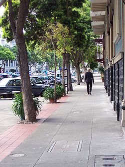
provide attractive public green spaces, but the Duboce Triangle is most notable for its lushly landscaped sidewalks and well-maintained Victorian flats and apartment buildings. These are the direct result of San Francisco's rejection of the wholesale demolition of Victorians and their replacement with slab-like public housing that marred the Western Addition in the 1960s. The city used the federal government's slum clearance dollars to renovate the mostly-19th century housing stock instead, and also to plant street trees, bury utility wires underground, and to widen sidewalks and narrow streets. With its now-mature trees and rejuvenated homes, the Duboce Triangle's distinctly residential and yet urbane feel is more remarkable given its proximity to busy Market Street, the city's main thoroughfare.
The official Duboce Triangle Neighborhood Association map excludes the point of the triangle at Market and Waller. This area is sometimes known as Mint Hill, after the United States Mint
San Francisco Mint
The San Francisco Mint is a branch of the United States Mint, and was opened in 1854 to serve the gold mines of the California Gold Rush. It quickly outgrew its first building and moved into a new one in 1874. This building, the Old United States Mint, also known affectionately as The Granite Lady,...
, an imposing building on a steep rocky cliff overlooking the intersection of Market and Duboce streets. However, most of the homes in this area are similar in character of the rest of Duboce Triangle.
This neighborhood was long unrecognized as a neighborhood until the late seventies. Originally most of the inhabitants were Scandinavian which is shown in many of the buildings in the neighborhood.
External links
- San Francisco GLBT Neighborhood Guide, Gay & Lesbian News, MyCastro.com
- Duboce Triangle Neighborhood Association
- DTNA official map (click on map for full-size version)
- Google map of neighborhood
37.7667°N 122.4333°W