
Drinkwater, Saskatchewan
Encyclopedia
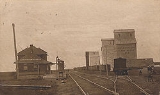
Drinkwater is a village in Saskatchewan, located on a branch of the Canadian Pacific Railway
, 18 miles south-east of Moose Jaw and is named for Charles Drinkwater, an original director of the railway. It can be reached via Saskatchewan Highway 39
.
Canadian Pacific Railway
The Canadian Pacific Railway , formerly also known as CP Rail between 1968 and 1996, is a historic Canadian Class I railway founded in 1881 and now operated by Canadian Pacific Railway Limited, which began operations as legal owner in a corporate restructuring in 2001...
, 18 miles south-east of Moose Jaw and is named for Charles Drinkwater, an original director of the railway. It can be reached via Saskatchewan Highway 39
Saskatchewan Highway 39
Highway 39 is a provincial paved undivided highway located in the southern portion of the Canadian province of Saskatchewan connecting North Portal and Moose Jaw in the north. This is a primary Saskatchewan highway maintained by the provincial and national governments providing a major trucking...
.
Location
- Dominion Land Survey Sec.29, Twp.15, R.23, W2
- Long (DMS) 50° 18' 00" N
- Lat (DMS) 105° 08' 00" W
- Time zone (est) UTC-6UTC-6UTC−06 is an identifier for a time offset from UTC of −06. This time is used in:-Central America:*Belize*Costa Rica*El Salvador*Guatemala*Honduras*Nicaragua-Central Standard Time:...
Location relative to other communities
| North: Belle Plaine Belle Plaine, Saskatchewan -See also:*Highway 642*Highway 1*Qu'Appelle River Dam*Saskferco-External links:*********... |
||
| West: Moose Jaw Moose Jaw, Saskatchewan Moose Jaw is a city in south-central Saskatchewan, Canada on the Moose Jaw River. It is situated on the Trans-Canada Highway, west of Regina. Residents of Moose Jaw are known as Moose Javians. It is best known as a retirement and tourist city that serves as a hub to the hundreds of small towns... , Bushell Park Bushell Park, Saskatchewan Bushell Park is a hamlet in Saskatchewan. It is located 5 km south of Moose Jaw and is home to CFB Moose Jaw a.k.a 15 Wing, Moose Jaw, where the Snowbirds flight demonstration team is based. The Moose Jaw airshow is performed from the base. There is a scout camp 2km to the east, which is often used... |
Drinkwater | East: Rouleau Rouleau, Saskatchewan -Location:-External links:*** Encyclopedia of Saskatchewan... |
| South:Briercrest Briercrest, Saskatchewan -Area statistics:*Lat 50° 10' 00" N*Long 105° 16' 00" W*Dominion Land Survey Section 18 Tsp 14 Rge 24 W2*Time zone UTC-6-External links:******... |