
Doubs River
Encyclopedia
The Doubs is a 453 km long river
in eastern France
and western Switzerland
, left tributary of the Saône
. Its source is near Mouthe
in the western Jura mountains
.
First it flows northeast, more or less along the French-Swiss border (forming the border for approx. 40 km). Near Montbéliard
it turns southwest, until it flows into the river Saône
in Verdun-sur-le-Doubs
, approx. 20 km northeast of Chalon-sur-Saône
. Its entire course resembles an inverted letter U, with the northeastern corner the only point at which the Doubs flows into Switzerland as far as Saint-Ursanne
.
The Doubs flows through the following Departments of France, Cantons of Switzerland
, and cities:
Tributaries include:
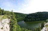
The river forms several lakes:
River
A river is a natural watercourse, usually freshwater, flowing towards an ocean, a lake, a sea, or another river. In a few cases, a river simply flows into the ground or dries up completely before reaching another body of water. Small rivers may also be called by several other names, including...
in eastern France
France
The French Republic , The French Republic , The French Republic , (commonly known as France , is a unitary semi-presidential republic in Western Europe with several overseas territories and islands located on other continents and in the Indian, Pacific, and Atlantic oceans. Metropolitan France...
and western Switzerland
Switzerland
Switzerland name of one of the Swiss cantons. ; ; ; or ), in its full name the Swiss Confederation , is a federal republic consisting of 26 cantons, with Bern as the seat of the federal authorities. The country is situated in Western Europe,Or Central Europe depending on the definition....
, left tributary of the Saône
Saône
The Saône is a river of eastern France. It is a right tributary of the River Rhône. Rising at Vioménil in the Vosges department, it joins the Rhône in Lyon....
. Its source is near Mouthe
Mouthe
Mouthe is a commune in the Doubs department in the Franche-Comté region in eastern France.-Geography:The village is located south of Pontarlier in the Jura Mountains on the Swiss border. The source of the Doubs River is from Mouthe. In Mouthe was recorded the lowest temperature ever in France...
in the western Jura mountains
Jura mountains
The Jura Mountains are a small mountain range located north of the Alps, separating the Rhine and Rhone rivers and forming part of the watershed of each...
.
First it flows northeast, more or less along the French-Swiss border (forming the border for approx. 40 km). Near Montbéliard
Montbéliard
Montbéliard is a city in the Doubs department in the Franche-Comté region in eastern France. It is one of the two subprefectures of the department.-History:...
it turns southwest, until it flows into the river Saône
Saône
The Saône is a river of eastern France. It is a right tributary of the River Rhône. Rising at Vioménil in the Vosges department, it joins the Rhône in Lyon....
in Verdun-sur-le-Doubs
Verdun-sur-le-Doubs
Verdun-sur-le-Doubs is a commune in the Saône-et-Loire department in the region of Bourgogne in eastern France.It is located in southern Burgundy at the confluence of the Doubs and the Saône in the Bresse plain, near Beaune and Chalon-sur-Saône....
, approx. 20 km northeast of Chalon-sur-Saône
Chalon-sur-Saône
Chalon-sur-Saône is a commune in the Saône-et-Loire department in the region of Bourgogne in eastern France.It is a sub-prefecture of the department. It is the largest city in the department; however, the department capital is the smaller city of Mâcon....
. Its entire course resembles an inverted letter U, with the northeastern corner the only point at which the Doubs flows into Switzerland as far as Saint-Ursanne
Saint-Ursanne
Saint Ursanne is a city and a former municipality of the district of Porrentruy in the canton of Jura, Switzerland which has preserved its medieval character. The city contains many historical curiosities, including collegiate churches, a cloister, ruins of a castle, and a hermitage...
.
The Doubs flows through the following Departments of France, Cantons of Switzerland
Cantons of Switzerland
The 26 cantons of Switzerland are the member states of the federal state of Switzerland. Each canton was a fully sovereign state with its own borders, army and currency from the Treaty of Westphalia until the establishment of the Swiss federal state in 1848...
, and cities:
- Doubs (F): PontarlierPontarlierPontarlier is a commune and one of the two sub-prefectures of the Doubs department in the Franche-Comté region in eastern France.-History:...
- Neuchâtel (CH)
- Jura (CH): Saint-UrsanneSaint-UrsanneSaint Ursanne is a city and a former municipality of the district of Porrentruy in the canton of Jura, Switzerland which has preserved its medieval character. The city contains many historical curiosities, including collegiate churches, a cloister, ruins of a castle, and a hermitage...
- Doubs (F): Montbéliard, BesançonBesançonBesançon , is the capital and principal city of the Franche-Comté region in eastern France. It had a population of about 237,000 inhabitants in the metropolitan area in 2008...
- Jura (F): DoleDole, JuraDole is a commune in the Jura department in the Franche-Comté region in eastern France, of which it is a subprefecture ....
- Saône-et-LoireSaône-et-LoireSaône-et-Loire is a French department, named after the Saône and the Loire rivers between which it lies.-History:When it was formed during the French Revolution, as of March 4, 1790 in fulfillment of the law of December 22, 1789, the new department combined parts of the provinces of southern...
(F): Verdun-sur-le-DoubsVerdun-sur-le-DoubsVerdun-sur-le-Doubs is a commune in the Saône-et-Loire department in the region of Bourgogne in eastern France.It is located in southern Burgundy at the confluence of the Doubs and the Saône in the Bresse plain, near Beaune and Chalon-sur-Saône....
Tributaries include:
- LoueLoueThe Loue is a river of eastern France, a left tributary of the Doubs, which it joins downstream of Dole. Its source is a karstic spring in the Jura mountains near Ouhans, which at least partly receives its water from the Doubs...
- Dessoubre
The river forms several lakes:
- Lac des BrenetsLac des BrenetsLac des Brenets or Lac de Chaillexon is a lake on the Doubs River on the border of Switzerland and France.-External links:* at Les Brenets...
(elevation 750 m) - Lac de MoronLac de MoronLac de Moron is a lake formed by damming the Doubs River on the border of France and Switzerland. It can be reached from Les Planchettes or Les Brenets in the Canton of Neuchâtel and from Le Barboux in the Doubs department ....
(elevation 716 m) - Lac de Biaufond (elevation 610 m)