
Districts of Sudan
Encyclopedia
The States of Sudan
were subdivided into 133 district
s. With the adoption of the Interim National Constitution of Sudan and the Interim Constitution of Southern Sudan , the ten states of South Sudan
are however now divided into counties.
The districts are listed below, by state:
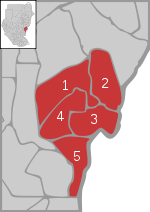
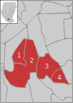
Al Qadarif
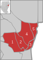
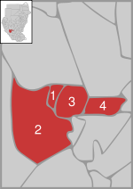
Kassala
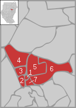
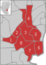
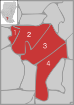
Khartoum
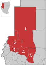
North Darfur
North Kurdufan
Northern
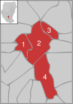
Sennar
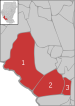
South Darfur
South Kurdufan
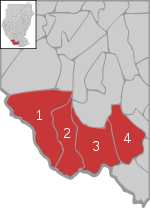
West Darfur
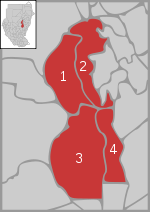
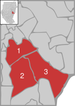
Central Equatoria
East Equatoria
Jonglei
North Bahr al Ghazal
Warab
West Bahr al Ghazal
West Equatoria
States of Sudan
Below is a list of the 15 states of Sudan, organized by their original provinces during the period of Anglo-Egyptian Sudan. Arabic language versions are, as appropriate, in parentheses. States that were not provinces before 1994 are marked with . Transliterations from Arabic to English may vary;...
were subdivided into 133 district
District
Districts are a type of administrative division, in some countries managed by a local government. They vary greatly in size, spanning entire regions or counties, several municipalities, or subdivisions of municipalities.-Austria:...
s. With the adoption of the Interim National Constitution of Sudan and the Interim Constitution of Southern Sudan , the ten states of South Sudan
South Sudan
South Sudan , officially the Republic of South Sudan, is a landlocked country located in the Sahel region of northeastern Africa. It is also part of the North Africa UN sub-region. Its current capital is Juba, which is also its largest city; the capital city is planned to be moved to the more...
are however now divided into counties.
The districts are listed below, by state:
Al Jazirah
- Al Kamlin District
- Sharq al Gazera District
- North al Gazera District
- Al Mahagil District
- South al Gazera District
- Um Al Gura District
- East al Gazera District
Al QadarifAl Qadarif (state)Al Qadarif , also spelt Gadaref or Gadarif, is one of the 15 wilayat or states of Sudan. It has an area of 75,263 km² and an estimated population of approximately 1,400,000 . Al Qadarif is the capital of the state; other towns include Doka and Gallabat....
- Al Faw District
- Al Gadaref District
- Al Rahd District
- Al Galabat District
Blue Nile
- Ad Damazin District
- Al Roseires District
- Geissan District
- Baw District
- Al Kurumik District
KassalaKassala (state)Kassala is one of the 15 wilayat of Sudan. It has an area of 36,710 km² and an estimated population of approximately 1,400,000 . Kassala is the capital of the state; other towns in Kassala include Aroma, Hamishkoreb, and Khor Telkok....
- Seteet District
- Nahr Atbara District
- Kassala District
- Al Gash District
- Hamashkorieb District
- Al Fushqa District
KhartoumKhartoum (state)Khartoum is one of the 15 states of Sudan. It has an area of 22,122 km2 and an estimated population of approximately 7,152,102 . Khartoum, the national capital of Sudan, is the capital of the Khartoum State....
- Khartoum District
- Um Badda District
- Omdurman District
- Karary District
- Khartoum Bahri District
- Sharg En Nile District
- South Khartoum District
North DarfurNorth DarfurNorth Darfur is one of the 15 wilayat or states of Sudan. It is one of the three states composing the Darfur region. It has an area of 296,420 km² and an estimated population of approximately 1,583,000 . Al-Fashir is the capital of the state...
- Mellit District
- Kutum District
- Kabkabiya District
- Al Fasher District
- Um Kadada District
North KurdufanNorth KurdufanNorth Kurdufan is one of the 15 wilayat or states of Sudan. It has an area of 185,302 km² and an estimated population of 2,529,370 . Al-Ubayyid is the capital of the state.North Kurdufan is generally arid and desert.- History :...
- Sowdari District
- Jebrat al Sheikh District
- Sheikan District
- Bara District
- Um Rawaba District
- En Nuhud District
- Ghebeish District
NorthernNorthern, SudanNorthern is one of the 15 wilayat or states of Sudan. It has an area of 348,765 km² and an estimated population of 833,743 . Dongola is the capital of the state. The town of Wadi Halfa, a headquarters of the British in the late nineteenth century, is located in the north of the province....
- Wadi Halfa District
- Dongola District
- Merawi District
- Addabah District
Red Sea
- Halayeb District
- Port Sudan District
- Sinkat District
- Tokar District
River Nile
- Abu Hamad District
- Berber District
- Ad Damer District
- Atbara District
- Shendi District
- Al Matammah DistrictAl Matammah DistrictAl Matammah District is a district of the Al Jawf Governorate, Yemen. As of 2003, the district had a population of 28,935 inhabitants....
SennarSennar (state)Sennar is one of the 15 wilayat or states of Sudan. It has an area of 37,844 km² and an estimated population of approximately 1,100,000 . Singa is the capital of Sennar State. Another significant town is Sennar , largest city in the state...
- Sennar District
- Singa District
- Ad Dinder District
South DarfurSouth DarfurSouth Darfur is one of the 15 wilayat or states of Sudan. It is one of the three states that compose the region of Darfur in western Sudan. It has an area of and an estimated population of approximately 2,890,000 . Nyala is the capital of the state. The State was affected by the 2010 Sahel...
- Kas District
- Edd al Fursan District
- Nyala District
- Shearia District
- Al Deain District
- Adayala District
- Buram District
- Tulus District
- Rehed al Birdi District
South KurdufanSouth KurdufanSouthern Kordofan is one of the 15 wilayat or provinces of Sudan. It has an area of 158,355 km² and an estimated population of approximately 1,100,000 people . Kaduqli is the capital of the state...
- Dilling District
- Rashad District
- Abu Jubaiyah District
- Talodi District
- Kadugli District
- Lagawa District
- As Salam District
- Abyei DistrictAbyei DistrictAbyei District was a former district of Sudan, considered part of the state of West Kurdufan. Upon the dissolution of West Kurdufan in 2005, it was included in the state of South Kurdufan...
West DarfurWest DarfurWest Darfur is one of the 15 states of Sudan, and one of three comprising the Darfur region. It has an area of 79,460 km² and an estimated population of approximately 1,007,000 . It borders North and South Darfur to the east. The Chadian prefectures of Biltine and Ouaddaï lie to the west,...
- Kulbus District
- Al Geneina District
- Zallingi District
- Jebel Marra District
- Habillah District
- Wadi Salih District
- Mukjar District
White Nile
- Ad Douiem District
- Al Gutaina District
- Kosti District
- Al Jabalian District
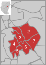
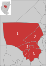
Central EquatoriaCentral Equatoria-Government:Executive*Governor - Maj. Gen. Clement Wani Konga*Deputy Governor and Minister of Education, Science and Technology - Mr. Manase Lomole Waya *Minister of Education - Lokulenge Lole Lokule...
- Note: These districts have been superseded by counties; see Counties of South SudanCounties of South SudanThe ten states of the East African country of South Sudan are divided into 86 counties. The ten states are Central Equatoria, Eastern Equatoria, Jonglei, Lakes, Northern Bahr el Ghazal, Unity, Upper Nile, Warrap, Western Bahr el Ghazal, and Western Equatoria....
- Terkaka District
- Juba DistrictJuba, SudanJuba is the capital and largest city of the Republic of South Sudan. It also serves as the capital of Central Equatoria, the smallest of the ten states of South Sudan. The city is situated on the White Nile and functions as the seat and metropolis of Juba County.- Population :In 2005, Juba's...
- Yei District
- Kajo Kaii District
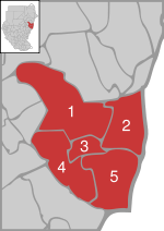
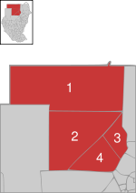
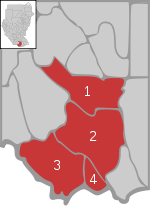
East EquatoriaEast Equatoria-External links:**...
- Note: These districts have been superseded by counties; see Counties of South SudanCounties of South SudanThe ten states of the East African country of South Sudan are divided into 86 counties. The ten states are Central Equatoria, Eastern Equatoria, Jonglei, Lakes, Northern Bahr el Ghazal, Unity, Upper Nile, Warrap, Western Bahr el Ghazal, and Western Equatoria....
- Magwi District
- Amatonge District
- Shokodom District
- Kapoeta District
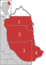
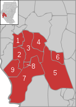
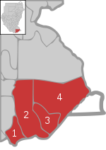
JongleiJongleiJonglei is one of the 10 states of South Sudan. Jonglei is the largest state in the Republic of South Sudan, with approximately 122,479 km2, as well as the most populous according to the controversial 2008 census conducted during present-day South Sudan's second period of autonomy. Bor is the...
- Note: These districts have been superseded by counties; see Counties of South SudanCounties of South SudanThe ten states of the East African country of South Sudan are divided into 86 counties. The ten states are Central Equatoria, Eastern Equatoria, Jonglei, Lakes, Northern Bahr el Ghazal, Unity, Upper Nile, Warrap, Western Bahr el Ghazal, and Western Equatoria....
- Fam al Zaraf District
- Ayod District
- Wat District
- Akobo District
- Bor DistrictBor DistrictBor District is a district of Serbia with seat in Bor. It has a population of 123,848 .-History:...
- Pibor District
Lakes
- Note: These districts have been superseded by counties; see Counties of Sudan
- Shobet District
- Rumbek District
- Yerol District
- Aliab District
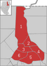
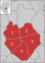
North Bahr al GhazalNorth Bahr al GhazalNorthern Bahr el Ghazal is one of the 10 states of South Sudan. It has an area of 30,543 km² and is part of the Bahr el Ghazal region. It borders South Darfur to the north, Western Bahr el Ghazal to the west and south, and Warab and Abyei to the east...
- Note: These districts have been superseded by counties; see Counties of South SudanCounties of South SudanThe ten states of the East African country of South Sudan are divided into 86 counties. The ten states are Central Equatoria, Eastern Equatoria, Jonglei, Lakes, Northern Bahr el Ghazal, Unity, Upper Nile, Warrap, Western Bahr el Ghazal, and Western Equatoria....
- Aryat District
- Aweil District
- Wanjuk District
- Malek District
Unity
- Note: These districts have been superseded by counties; see Counties of South SudanCounties of South SudanThe ten states of the East African country of South Sudan are divided into 86 counties. The ten states are Central Equatoria, Eastern Equatoria, Jonglei, Lakes, Northern Bahr el Ghazal, Unity, Upper Nile, Warrap, Western Bahr el Ghazal, and Western Equatoria....
- Al Mayom District
- Rabkona District
- Faring District
- Al Leiri District
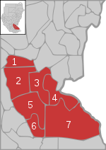
Upper Nile
- Note: These districts have been superseded by counties; see Counties of South SudanCounties of South SudanThe ten states of the East African country of South Sudan are divided into 86 counties. The ten states are Central Equatoria, Eastern Equatoria, Jonglei, Lakes, Northern Bahr el Ghazal, Unity, Upper Nile, Warrap, Western Bahr el Ghazal, and Western Equatoria....
- Tonga District
- Fashooda District
- Malut District
- Al Renk District
- Al Mabien District
- Mayot District
- Sobat District
- Baleit District
WarabWarab (state)Warrap, sometimes spelled Warab, is one of the 10 states of South Sudan, located in the Bahr el Ghazal region. It has an area of 31,027 km². Kuajok is the capital of Warrap state, replacing Warrap...
- Note: These districts have been superseded by counties; see Counties of South SudanCounties of South SudanThe ten states of the East African country of South Sudan are divided into 86 counties. The ten states are Central Equatoria, Eastern Equatoria, Jonglei, Lakes, Northern Bahr el Ghazal, Unity, Upper Nile, Warrap, Western Bahr el Ghazal, and Western Equatoria....
- Nahr Lol District
- Gogrial District
- Warab District
- Tonj District
West Bahr al GhazalWest Bahr al GhazalWestern Bahr el Ghazal is one of the ten states of South Sudan. It has an area of and is the least populous state in South Sudan, according to the controversial Sudanese census conducted in 2008. It is part of the Bahr el Ghazal region. Its capital is Wau. The state shares international borders...
- Note: These districts have been superseded by counties; see Counties of South SudanCounties of South SudanThe ten states of the East African country of South Sudan are divided into 86 counties. The ten states are Central Equatoria, Eastern Equatoria, Jonglei, Lakes, Northern Bahr el Ghazal, Unity, Upper Nile, Warrap, Western Bahr el Ghazal, and Western Equatoria....
- Raja District
- Wau District
- Nahr Jur District
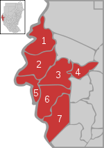
West EquatoriaWest EquatoriaWestern Equatoria is one of the 10 states of South Sudan. It has an area of 79,319 km². Its capital is Yambio. The state is divided into counties, each headed by a County Commissioner...
- Note: These districts have been superseded by counties; see Counties of South SudanCounties of South SudanThe ten states of the East African country of South Sudan are divided into 86 counties. The ten states are Central Equatoria, Eastern Equatoria, Jonglei, Lakes, Northern Bahr el Ghazal, Unity, Upper Nile, Warrap, Western Bahr el Ghazal, and Western Equatoria....
- Tombura District
- Yambio District
- Meridi District
- Mundri District