

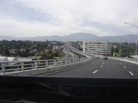
Distribuidor Vial
Encyclopedia
Mexico
The United Mexican States , commonly known as Mexico , is a federal constitutional republic in North America. It is bordered on the north by the United States; on the south and west by the Pacific Ocean; on the southeast by Guatemala, Belize, and the Caribbean Sea; and on the east by the Gulf of...
freeway located at the west side of Mexico City
Mexico City
Mexico City is the Federal District , capital of Mexico and seat of the federal powers of the Mexican Union. It is a federal entity within Mexico which is not part of any one of the 31 Mexican states but belongs to the federation as a whole...
called "Distribuidor Vial San Antonio" and at the east side of the city another one called "Distribuidor Vial Zaragoza".
It was built under the mandate of the previous head of government, Andrés Manuel López Obrador
Andrés Manuel López Obrador
Andrés Manuel López Obrador , also known as AMLO or El Peje, is a Mexican politician who held the position of Head of Government of the Federal District from 2000 to 2005, before resigning in July 2005 to contend the 2006 presidential election, representing the unsuccessful Coalition for the Good...
between 2002 and May 14th 2006.
It's called also "Segundo piso" (second floor).
The "Distribuidor Vial" is part of a much more ambitious project (los "Segundos Pisos" more than 180 km all over the city). A series of roads elevated, all over existing roads, to solve some of the problems of traffic of Mexico City.
Main purposes
The main purpose of the Distribuidor Vial is to solve traffic jams in the following avenues and roads:- Anillo Periferico Sur (Exterior Circuit)
- Eje 5 Sur San Antonio(Main route 5 South)
- Eje 10 Sur San Jerónimo (Main route 10 South)
- Revolución (Interior Circuit)
- Viaducto Río Becerra (Viaducto Miguel Alemán)
- Eje 6 Sur Holbein (Main route 6 South)
- Las Flores
- Barranca del Muerto
- Rómulo O'Farrill
Names
The Distribuidor Vial is named after the streets it crosses:- San Antonio (East-South)(San Antonio Av.-Lomas de Plateros)
- San Jerónimo (South-East) (San Jerónimo Av.-Lomas de Plateros)
- Las Torres (South-East) (Las Torres Av.-San Antonio Av.)
- Las Flores (North-South) (Las Flores Av.-San Jerónimo Av.)
- Zaragoza (North-South-North) (Ignacio Zaragoza Road)
All those streets, except Zaragoza, belong to the same network of freeways.